Construction History
Langley Dam, or Kalmia Mills Dam as it was originally known, has a long and turbulent history. While this case history focuses on failure of the dam as a result of the August 31, 1886, Charleston, South Carolina earthquake, the dam actually failed or came close to failing on at least seven other occasions. Kalmia Mills Dam was originally conceived by leaders of the Confederacy during the Civil War in the summer of 1864; the South was desperate for the manufacturing boost that a paper and/or cotton mill powered by water from a large dam could provide. In the late summer and fall of 1864, 5,000 acres of land were purchased, a dam was surveyed and clearing began for the site that would become Kalmia Mills. Colonel John L. Branch, a graduate of the Citadel, was the Chief Engineer and architect of the Kalmia Mills factory and dam. Construction activities were paused in 1865 but resumed in January 1866. In April 1866, the Charleston Daily News wrote that “Extensive mills are now in course of construction in Kalmia, S.C. on a larger scale than any heretofore in operation in the South.” A newspaper advertisement was published that same month by a local contractor, Murry, soliciting labor to build the dam.
As of December 1866, the dam was rapidly approaching completion. However, finding capital to finance the dam and mill in the years following the Civil War was very difficult and at a December 19, 1866, meeting of the Board of Directors, the Treasurer was ordered to “open the books” to attract new capital investment of ~$120,000 which was thought to be necessary to provide enough funding to complete construction and get the mill in operation, hopefully by May 1, 1867.
Efforts to complete the dam and mill continued to languish and on April 23, 1867, Kalmia Mills was put up for auction and bought by H. Cogswell. The need for the auction was apparently due to not raising enough additional capital and possibly complicated by mill equipment that was defective. At the time of the auction, the dam and appurtenant structures were 80% complete.
A major blow to completing the dam occurred on August 16, 1867, when a historic flood on Horse Creek failed dams upstream of Kalmia Mills that in turn caused Kalmia Mills Dam (which was still construction idled) to partially fail and the next dam downstream, Bath Paper Mills Dam, to fail. Subsequently, in December 1867, Francis Murry, contractor for dam construction, sued Kalmia Mills for $20,000 to recover losses he had from non-payment of money owed him for construction services. Six months later, Murry’s estate, which may have included land for the dam’s borrow source, was in bankruptcy.
Financial issues continued to afflict efforts to complete the dam. On March 24, 1868, the US District Court allowed the March 19 sale of Kalmia Mills to W C Langley & Company from Harvey Cogswell for $160,000. However, in December of the same year, the newest owner, Langley, offered Kalmia Mills for sale, advertised in the Charleston Daily News.
In an eerie foreshadowing of the 1886 failure, an 1869 article in the Banner of the South newspaper stated, “We have a very striking instance of this [locating new mills very close to mainline railroads] in the Kalmia Mills in this State, where in order to secure a position on the Railroad, immensely expensive engineering had to be restored to create water power, risking great injury to the South Carolina Railroad”. Langley was not able to sell the mills and dam and in April 1870 the Langley organization began to seek a builder to complete the mill dam.
Finally, in the early Spring of 1871 the dam, now named after its new owner, Langley, was completed—approximately six years after construction initially began—and production from the cotton mill began on March 29, 1871. Shortly thereafter, the Abbeville South Carolina Press and Banner newspaper claimed that Langley mill pond was the largest mill pond in the South.
Dam Description
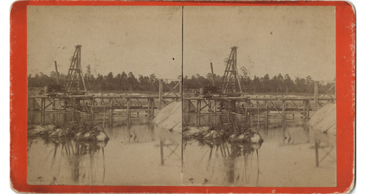
In July 1871, Langley Dam was described as being about 400 yards long, 80 feet at the base and 18 feet wide at the crest. A later description of the dam from Water-Power of the United States (U.S. Census Office, 1880) stated that the Langley Dam construction type was earth and crib-work, it was 1,000 feet long and 24 feet high ponding water of over 700 acres to a depth of 10 feet. A newspaper report published in 1866, several years before the dam was completed, showed the dam averaged 180 feet at the base, was 27 feet high, had a crest width of 18 feet, 5 feet of freeboard and embankment slopes of 3H:1V. It is not clear if these discrepancies in the shape and size of Langley Dam were due to inaccurate reporting or to the fact that construction (and re-construction) of the dam took place over a 14 year period that may have included actual changes to the dimensions. Based on the available nearby borrow sources and one reference to transport of material from the west (right) side of the dam, the embankment material was likely derived from Cretaceous age deposits which consisted of sand with minor amounts of clay. It is also quite possible that some Holocene age alluvial floodplain deposits were used in construction of the dam. The method of placement is unknown, but it appears safe to say that based on recent soil investigations at the site, there was little if any compaction. It is obvious that the design and construction practices employed in the building of Langley dam did not meet modern day criteria; however, beyond the information given above, details of the design and construction are not known.

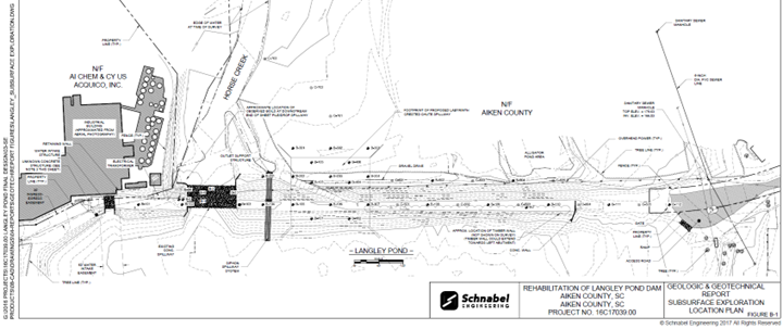
The following description of Langley dam is taken from Schnabel (2017) and represents the dam as it existed in 2017. It is not known how closely the 2017 condition matched the 1886 dam configuration and properties.
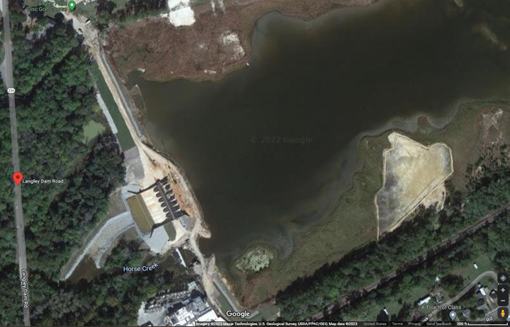
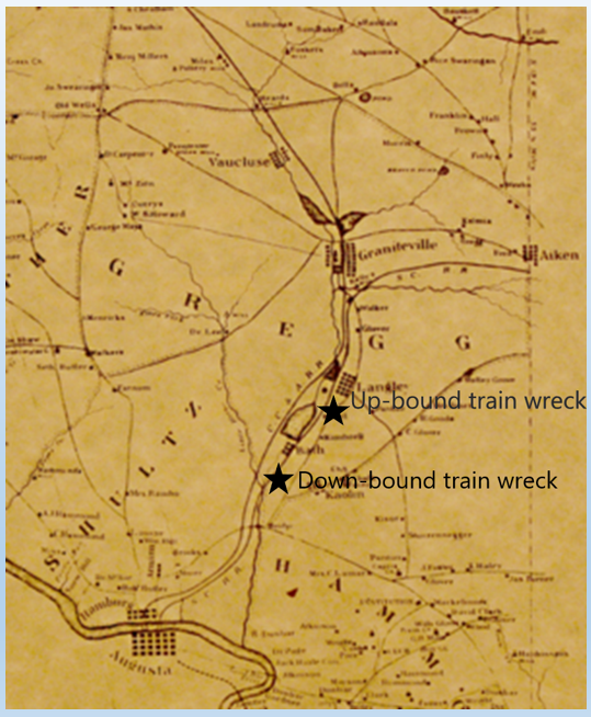
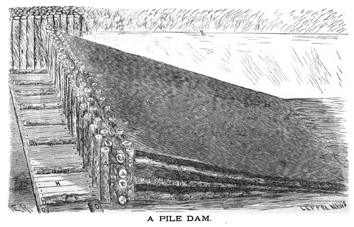
The existing dam consists of earthen embankment sections and a concrete spillway section. The earthen embankment sections have a maximum height on the order of 35 feet. The dam has a crest length of approximately 1700 feet, as measured from the right abutment to the left abutment and including the existing concrete spillway. The upstream and downstream slopes of the earthen embankment have grades of approximately 2 horizontal to 1 vertical. The concrete spillway section, which is located near the left abutment, is on the order of 120 feet wide and consists of an “ogee” crested spillway and multiple gates. The ogee crested spillway controls the normal pool elevation with a crest elevation of 173.4 feet. Based upon historical documents obtained from the SCDHEC files, the ogee-crested spillway is believed to be supported by timber cribbing, while seepage control beneath the structure is provided by timber (Wakefield) piles. Two levels of gates are located adjacent to the main ogee section of the spillway. Brick and mortar construction is present around the left-most gated portion of the spillway. A bridge spans the spillway section with three piers located just upstream of the ogee crest. An earthen channel auxiliary spillway, with a crest elevation of about 177 feet and width on the order of 240 feet, is located through the embankment near the right abutment of the dam. The dam impounds a reservoir with a maximum storage of approximately 4,500 acre-feet at the crest of the embankment. The normal pool has a surface area of approximately 260 acres.
Failure during the Charleston, SC 1886 Earthquake
The 1886 Charleston earthquake occurred at approximately 9:50 p.m. local time, on August 31. The earthquake had an estimated moment magnitude (M) of 6.9–7.3 and a maximum Modified Mercalli Intensity (MMI) of X (Extreme). The MMI value at Langley Dam was at least VIII and was possibly as high as MMI IX due to local amplification of ground motion. The dam failure appears to have occurred coincident with the ground shaking, which likely lasted for minutes, or within a few minutes after the ground shaking subsided.
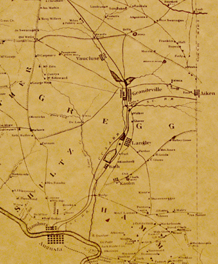
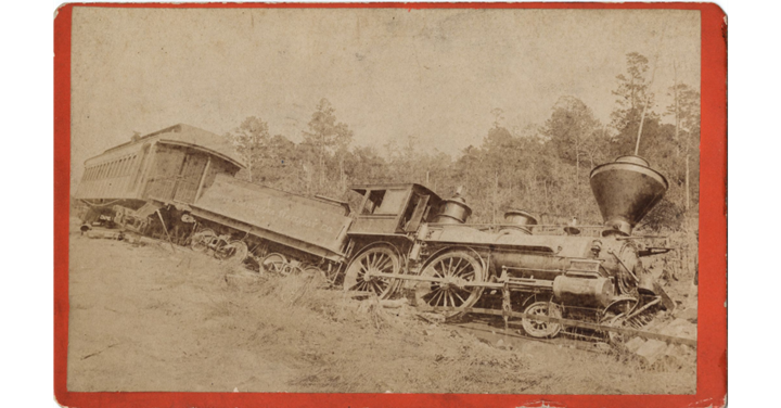
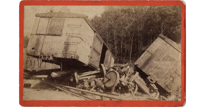
The water released by the failure of Langley and the next dam downstream, Bath, moved downstream and encountered the tracks of the South Carolina Railroad near the intersection with Horse Creek. At almost exactly the same time as the flood waters reached the track, a mixed train (passengers and livestock) that had departed Augusta, GA at 10:07 p.m. bound for Charleston began to cross the tracks below Langley. The engine and livestock cars were washed off the tracks but miraculously the two passenger cars were unharmed even though the tracks in front and behind them were eventually completely inundated.
The train’s fireman was killed. A few livestock were also lost, but most were able to scramble to safety. Mr. D. S. Henderson, a passenger on this train, was interviewed by the Augusta Chronicle the following day. After describing in great detail the terrifying events of the train wreck, he concluded with “Altogether it is one of the most thrilling incidents of my life. Good day.”
An engine from a second train (the Augusta bound train), this one passengers only, approaching from the opposite direction on the same track also de-railed at about the same time. This derailment occurred closer to the dam within a half mile of the Langley Community. Once again, the train’s fireman was killed in the wreck, but the engineer survived. No passengers were injured.
Henry Grady’s Trip to Charleston via Langley Dam
In 1886, Henry W. Grady was the managing editor of the Atlanta Constitution newspaper and was known as the “Voice of the New South”. After experiencing the earthquake in his Atlanta home and hearing early reports of the damage at Charleston, Grady decided that this might be the story of a lifetime, so he decided to leave for Charleston the following day. His observations from his trip by rail and other means were carried in the Constitution over the next several days and are some of the most detailed, non-scientific accounts of the effects of the earthquake. As a testament to the impact of his reporting on the earthquake, in 1946, 60 years after the earthquake, the Detroit Times wrote a feature article on Grady and his trip to Charleston.

By the morning of September 2, Grady’s train had made it as far as Augusta where he was informed that they could not continue because of the track washout at Langley. Grady was determined to reach Charleston and made arrangements to meet a train on the other side of the washed-out tracks. Upon arriving at Langley, Grady described the scene as follows:
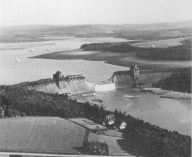
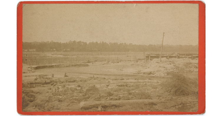
The first signs of the convulsion that were writ on the earth were found at Langley mills… Langley Pond was a bare waste. Several hundred acres of pond area were bare, the pools being filled with operatives and country people catching fish… The Langley Pond, the pride of the area, was gone, and the forest for a half mile below looked as if a cyclone had torn through them. This dam cost $50,000. It was about 400 feet [sic] across, and two carriages could have driven abreast easily over its top. The sides were properly sloped and sodded. The earthquake had wrenched this enormous structure right and left. Great cracks, converging nowhere, but apparently made in caprice, disfigured the approaches. It was through such cracks as these that the water made its way and swept the dam out of existence. These fissures were not made by the earth sinking, but by its being wrenched apart. Both sides of the fissures were usually level. Into one of these giant cracks a pole was lowered without reaching the bottom. A hundred feet away from the pond the solid earth was wrenched into fissures that had no perceptible drift of shape or direction. There had been no eruption and no extraneous under sand was found in the cracks. It was simply as if some tremendous power had torn the earth apart, cutting the cracks clean and definite. The largest crack, was perhaps, two feet across and bottomless as far as appearances could reach.
From Grady’s account, it is clear that the dam and abutments experienced extensive cracking due to the earthquake. An article in the Columbia Sentinel (Harlem, Georgia) states that the dam was broken in about a dozen places.
Why Did the Dam Fail during the Earthquake?
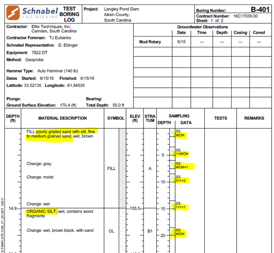
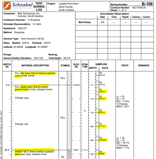
The Schnabel (2017) geotechnical data indicates that the modern embankment is comprised primarily of sand and silty sand, much of which is very loose. Some of the foundation soils are also very weak, especially on the right side. One 2017 boring encountered weathered schist at a shallow depth and Schnabel concluded that a residual soil horizon extends beneath the dam at shallow depths.
Given the regional trends observed with MMI values, which are consistent with expected site response, Langley Dam would have been in a zone of enhanced ground motion. While it seems likely that some portions of the embankment and possibly the foundation liquefied given the very loose sands found by the Schnabel 2017 investigation, Grady’s observations do not support an extensive liquefaction event that would have produced enough crest settlement to fail by overtopping. Instead, it appears that the dam experienced exceptionally large deformations and cracking which were increased due to significant amplification of ground motion across the Piedmont crystalline bedrock to alluvial sediment high acoustic impedance boundary. The description of the failure seems consistent with a large-scale lateral spreading event in which the majority of the movement occurred in the lower part of the embankment or its foundation.

The evidence suggests that open through-going cracks accompanied by a rapidly evolving internal erosion event began the breach of the dam. Flow through these cracks likely coalesced into larger openings in the dam and a complete breach of the dam followed. However, because the most damaged portion of the dam breached and was carried downstream, it is possible that the liquefaction intensity and associated deformations were greater in the missing part of the embankment which may have resulted in deformations large enough for localized overtopping of a lowered crest.
Lessons Learned
- An interrupted, protracted dam construction history sets the stage for issues during operation of the dam. The construction of Langley dam began in late 1865 and was not completed until almost six years later primarily due to inadequate financing for the dam and mill project. There was at least one multi-year hiatus in construction during that time and the partially built dam also experienced significant damage from a flood in 1867. Then, during the first filling of Langley Pond, the dam failed and had to be re-built.
- While major earthquakes are rare in the central and eastern United States, they do occur, and given a combination of poor construction practices, poor foundation conditions, and locally enhanced ground shaking, disastrous results can occur.
- Langley Dam was built in a band of anomalously high ground motion amplification that trends just southeast of, and essentially parallel to, the Fall Line that divides the Piedmont and Coastal Plain physiographic provinces. Several modern-day existing dams are built at very similar locations in the southeastern U.S.
- Reconstruction of dams driven by economic or other short-term needs may result in poor construction and additional failures later as happened twice to Langley Dam in less than six months after the August 31, 1886 Charleston earthquake.
Other Notable Incidents and Failures at Langley Dam
Given its history, it is rather surprising that Langley Dam is still in place today. The following is a list of failure or near-failure events in the history of Langley Dam:
- 1867 (August 16) – Partially complete dam suffers major damage due to flooding.
- 1871 (July 18) – Dam fails on first filling.
- 1877 (April 13) – Strong winds push water over the crest for most of a day but heroic efforts by the local population save the dam from failure.
- 1886 (August 31) – Dam fails during 6.9-7.3 M Charleston Earthquake.
- 1886 (November 29) – Dam fails as post-earthquake re-construction is almost complete.
- 1887 (January 14) – Dam fails again during post-earthquake re-construction.
- 1920 (March 28) – Heavy rains in the Horse Creek Valley cause other dams in the drainage to fail, and Langley Dam is overtopped, but does not fail.
- 1929 (October 1) – Dam is intentionally breached to prevent overtopping.
Of these other incidents, the failure after first filling is the best documented. At approximately 3:30 on the morning of July 18, 1871, Langley Dam failed suddenly and catastrophically. An inspection at 1:30 that morning revealed no issues with the dam but just two hours later the night watchman heard a roaring sound and looked outside to see the middle of the dam breached and eventually almost 1/2 the length of the dam was washed away.
There had been heavy rains in the days before the failure but there was still 4 to 5 feet of freeboard at time of failure and recent rain was not considered a factor. The cascading failure also failed Bath Paper Mills Dam which resulted in the owners of Bath Paper Mills suing the Langley Company.
Several theories were advanced as to the cause of the first-filling failure:
- The dam did not fail by overtopping and failure initiated at the center or base; it was “Noticed that only that portion of the dam that was not sustained by piling was swept away.” (Bold italics added from Charleston Daily News, July 21, 1871, p.4.)
- “One of the most plausible opinions advanced is that a certain portion of the dam was built over a quicksand, and that during the night there must have been a land slide in the dam. This afforded an aperture to the water which soon made itself master of the situation.” (The Charleston daily News, July 20, 1871, p.2)
- “The cause of the breakage is not positively known, but the supposition is that either a musk rat had bored through some portion of the dam, thus giving room for the water to sap the whole structure, or else a land slide occurred at some part of it after the watchman had passed, thus allowing the water to flow over the dam.” (The Edgefield (SC) Advertiser, July 20, 1871, p.3)
As happened twice in 1886, the South Carolina Railroad was swept away near where the pond discharge meets Horse Creek.
References
(1) Wilson, H. (1886, September 8). A Thrilling Experience. Abbeville Press and Banner.
(2) Schnabel Engineering. (2017). Report of Subsurface Exploration and Geotechnical Engineering Evaluation – Proposed Rehabilitation of the Langley Pond Dam, Aiken County, South Carolina. Schnabel Reference #16C17039.00. Prepared for Joseph Berry, County Engineer, Aiken County, South Carolina.
(3) Grady, H. W. (1886, September 7). Fixing to Leave. Atlanta Constitution.
(4) Willoughby, R. H. (1983). Geologic map of the Graniteville quadrangle. Open File Report 31. South Carolina Department of Natural Resources, Geological Survey.
(5) Willoughby, R. H. & Howard, S.C. (2008). Geologic Map of the North Augusta 7.5-minute quadrangle, Aiken and Edgefield Counties, South Carolina. Geologic Quadrangle Map 43. South Carolina Department of Natural Resources, Geological Survey.
(7) Chapman et al. (1990). The Influence of the Coastal Plain Sedimentary Wedge on Strong Ground Motions from the 1886 Charleston, South Carolina, Earthquake. Earthquake Spectra, 6(4), 617-640.
(8) Kalmia Mills at Hampton. (1866, December 14). The Charleston Mercury.
(9) The Kalmia Mills. (1866, December 14). The Charleston Daily News.
(10) The Langley Cotton Factory . (1871 ,August 7). The Charleston News.
This case study summary was peer-reviewed by Eric Halpin P.E. (Halpin Consulting LLC).
Lessons Learned

Dam incidents and failures can fundamentally be attributed to human factors.
Learn more
Dams located in seismic areas should be evaluated for liquefaction, cracking, potential fault offsets, deformations, and settlement due to seismic loading.
Learn more
Dozens of dams can fail or be in danger of failing during a single event (i.e. swarming failures). Dam owners and regulators need to prepare for these types of events.
Learn more
Stability of the dam foundation and other geologic features must be considered during dam design.
Learn moreAdditional Lessons Learned (Not Yet Developed)
- Importance of seismic site response to ground motion experienced by a dam.
- The regional nature of the seismic amplification effect along and just to the southeast of the Fall Line at the boundary between the Piedmont and Atlantic Coastal Plain physiographic provinces.
- The risks of hastily re-building critical infrastructure like a dam to satisfy commercial interests without a careful consideration of how a previous failure (or failures) occurred.
- Detrimental effect of prolonged and interrupted construction of a dam, particularly an embankment dam.
- Importance of modern-day investigation and lab analyses in understanding earlier failures.

Design Standards No. 13: Embankment Dams - Chapter 13