Dam Construction and History
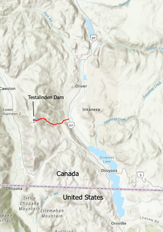
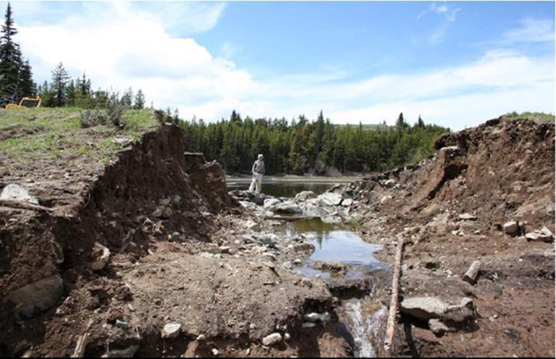
Testalinden Dam was constructed in the 1930s at the headwaters of Testalinden Creek at 1,810 m elevation near the summit of Mount Kobau, approximately 1,500 m above the Okanagan River valley below (see figures). The 2.5 m high dam was constructed from silty-sand and glacial till using horses and a Fresno scraper. There was no engineering design or supervision during construction [2].
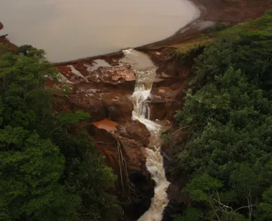
The original purpose of the dam was for water storage and irrigation [1, 3]. At the time of failure, the dam was assumed to be at full-supply level with an operable open channel spillway and an estimated reservoir volume of 29 acre-feet at top-of-crest. The portion of Testalinden Creek that extends from the dam site down to the debris fan apex at the valley floor is a steep, confined, V-shaped gully [4].
Ownership of the dam had changed hands a number of times. Repairs to address seepage problems were made in 1942, and a road was constructed across the dam around 1960 to access forest lands. By 1977-78, serious concerns about the dam’s safety were raised, and one report indicated that “the dam is in deplorable condition and should, in my (the inspector) opinion, be breached or rebuilt” [3]. Additional concerns were identified in inspection reports from 1985, 1988, and 1992. A subsequent review after the dam failure indicated that:
“… there was sufficient evidence to see a consistent pattern of concerns and warnings about the state of the structure dating back to the 1960’s. There is also no indication that actions had been taken to remedy the situation that has persisted for decades” [3].
At the time of failure, the dam was being used to supply drinking water for cattle in the summer [1].

Freshwater Dam Safety Regulation
In 2010, these types of dams in British Columbia (BC) were regulated under the 2000 BC Dam Safety Regulation [5] which had four loss of life consequences categories: Very High, High, Low, and Very Low. Testalinden Dam would have been classified in 2010 as Low Consequence, and in 2021 using updated legislation would be classified as Significant Consequence [6].
Dam Failure
In the spring of 2010, the snowpack in the Okanagan region was above the long-term average, and the weeks before the dam failure coincided with the first period of sustained hot weather for the year. No rainfall was recorded during the preceding three days or on the day of the event at the nearby Penticton weather station [1].
On Friday, June 11, 2010, a hiker noticed that Testalinden Lake was full and observed water from the reservoir overflowing both the dam and a road along the crest of the dam at the tallest portion of the structure where the sluice pipe was located. The hiker reported his observations at a local tourist information booth (discussed below). The dam breached two days later on Sunday, June 13 around 2:15 pm. A local engineering professor who performed a field investigation a short time after the failure drew the following conclusions:
“It is believed that the last surge of snowmelt, which was occurring at the time of the breach, created enough overflow velocity and resulting erosive energy to scour through a harder, grass-covered, section on the dam and expose a softer, more easily eroded earth core[…] A subsequent investigation discovered that over 75 years of service, significant settlement, surface erosion and rutting due to vehicle traffic across the dam embankment may have reduced the freeboard to zero. The small culvert placed originally for overtopping protection and located to the north of the breach location never carried more water than a trickle of water and was effectively non-functioning as a spillway.” [1]

Consequences, Close Calls, and a Missed Opportunity
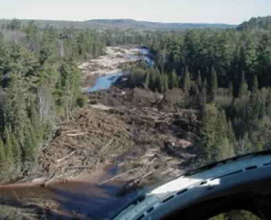
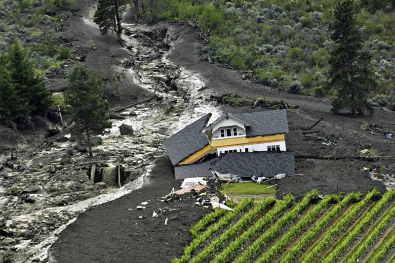
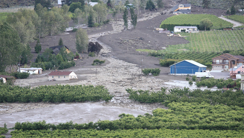
The land use in the downstream impact zone below the apex of the alluvial fan is a rural, agricultural setting. The debris flow damaged or destroyed five houses as well as orchards and vineyards. The debris flow blocked the main north-south Provincial highway and caused over CAD $20 million in losses.
While it was fortunate there was no loss of life, there were a few close calls. In one household, a mother was home with her 16-year-old daughter Sunday afternoon when she heard “a roaring thunder sound that wasn’t stopping.” Testalinden Creek flows downhill next to her property and was “[j]ust a wall of mud … coming down the creek.” After collecting her daughter from upstairs, she saw “a mountain of mud” carrying her vehicle towards their house. They escaped the house via a rear door and evacuated as quickly as possible, running through orchards and hopping several fences until they reached higher ground. They then turned around and saw a “mountain of mud with our garage heading our way.” An RCMP Corporal observed that “people likely would have died had the slide happened in the middle of the night when people were in bed.” [9]
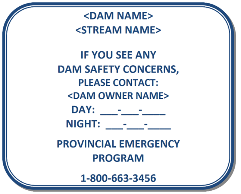
As noted above, a hiker had observed two days earlier on the Friday that Testalinden Lake was full, and that water from the reservoir was overflowing a road that crossed the dam. An opportunity to raise awareness with the correct provincial authorities and to attempt to intervene and stop the progression towards dam failure was missed. Although the hiker reported the overflow at a tourist information booth in nearby Osoyoos, and the message was dutifully passed along via the RCMP to provincial representatives, it did not reach the appropriate dam safety regulatory agency in time. A key factor was that the original message stated that a “forest road was overtopping” not that a dam was overtopping. This provided one of the key lessons learned and gave an impetus to improve signage at all regulated freshwater dams in BC.
Provincial Response to the Dam Failure
In the immediate aftermath, emergency response agencies, social service agencies, and Provincial agencies evacuated the impacted area and responded to the needs of local individuals. The BC Government compensated the affected parties beyond the limits of normal disaster financial assistance.
Given the severity of the event and the need to ensure public trust, the Province of BC took additional action. Four independent investigations of the cause of the dam breach were initiated, and the Commercial Investigations Unit of the government reviewed the dam’s history and investigated whether to proceed with formal charges against the dam owner [1]. However, two main activities should be highlighted:
- Within a month of the failure, the Deputy Solicitor General (DSG) (responsible for public safety and law enforcement) completed an independent review of the dam failure. The DSG’s report made 12 recommendations to “further strengthen the dam safety program and to ensure appropriate enforcement and compliance” [3]. A report on the progress on each recommendation was published three months later [7]. Copies of the review and progress report are provided in the “Other Resources” section of this Case Study. Key recommendations included:
- Allocate additional resources and staff dedicated to dam safety.
- Implement new policies and procedures to improve record-keeping, information sharing and emergency call-outs.
- Introduce a requirement for new signs at all very-high, high, and low-consequence dams on Crown Land. The signs must identify the dam and provide emergency contact information.
- Improve the dam safety and emergency response training of local government and emergency personnel.
- Update the provincial dams database to improve access by the public and local governments, including a public, web GIS-based interface. A screenshot of this interface is provided in the “Other Resources” section of this Case Study.
- Publish an annual dam safety program report (an example for 2020-21 is provided in the “Other Resources” section below).
- Update the provincial Dam Safety Regulation to increase accountability and awareness of dam owners, and to align the province’s dam failure consequence classification scheme with that of the Canadian Dam Association (CDA).
- The second major activity was the initiation of the Rapid Dam Assessment (RDA) project on June 15th, 2010:
- The RDA had three objectives: 1) assess all priority dams above populated areas, 2) identify any dams not meeting minimum specifications, and 3) take immediate action to address significant deficiencies.
- In order to complete the work quickly, the BC Dam Safety Program drew on field staff from within the Ministry and staff from the Compliance and Enforcement Division of the Ministry of Forests who had logistics capacity and field ops experience. Dam Safety Officers from headquarters and the regions trained the seconded staff in basic dam safety assessment, and the teams performed the field assessments in a timely manner. A link to a video that explains how this program worked is provided in the “Other Resources” section.
- At the time of the Testalinden Dam failure, there were 1,900 dams listed in the Provincial Dam Registry. Of those dams, 1,132 were assessed by RDA and 768 were deemed not to require assessment because they were known to be low risk because the owners of those dams had compliant dam safety programs (307 dams), the dam had been assessed within the previous 5 years (339 dams), or the dam did not pose a credible risk based upon the field knowledge of a Dam Safety Officer (122 dams).
- By September 2010, the RDA found that four dams required immediate follow-up attention and 379 dams required less urgent follow-up.
Changes to Dam Safety Management in British Columbia
Based upon the recommendation in the DSG’s review, many changes and improvements were made to British Columbia’s Dam Safety Program. Key accomplishments include the following:
- The British Columbia Dam Safety Regulation was amended to be consistent with the CDA’s downstream consequences classifications for dams [10] and new signage was put in place [11].
- The BC ministry responsible for dam safety now issues an annual dam safety program report [12].
- The Engineers and Geoscientists of BC (EGBC) produced new professional practice guidelines to be followed when carrying out Dam Safety Reviews in BC to meet the requirements of the Dam Safety Regulation [13].
- The BC Government’s dam safety website has been expanded and enhanced considerably [14].
Lessons Learned – Risks Posed by Earthen Dams Perched High Above Valley Floors
In addition to the changes to Dam Safety management in BC, important technical insights can also be learned from similar failures. Key insights can be gained from the 100-year historical record of dam failures in the Okanagan Region [1, 2, 15-17], many of which have relevance to regions in Canada and the Western USA:
- Most events have been associated with either late spring snowmelt, spring rains occurring on the snowpack, or intense localized convective rainstorms in the summer.
- Dam breaches can occur on hot sunny days in the spring, when snowmelt and saturated ground conditions occur in the headwaters of creeks flowing into the Okanagan valley.
- The dam failures were caused by either seepage-related piping or water flowing over the top of the dam.
- Many of the most destructive debris and mud flows were triggered by failure of earth dams located high above the valley floor. Although the volume of water released by the sudden failure of Testalinden Dam was smaller than many other dam failures, the steep creek gradient and breach discharge rate combined to create a condition in which the relatively small volume of water had sufficient energy and scour potential to grow into a mud flow at least one order of magnitude larger than the quantity of water released.
- Breaches into steep gradient channels can trigger larger, more destructive events such as debris floods and debris flows.
- These events can inflict both property damage and loss of life. Tannant recommends that dam safety risk management in these contexts include an assessment of the potential for debris flow generation and significant downstream consequences [1].
- Inundation areas can be much harder to predict due to bulking and the potential for avulsions [17].
- More generally, in the arid and semiarid regions of the western U.S., immense quantities of material have been moved downhill and deposited on lowlands by mud flows, with examples in Arizona, Utah, Nevada, New Mexico, and California. Tannant and Skermer [16] discuss the 30 May 1983 Ophir Creek mudflow in Nevada, which caused a cascading failure of two small earthen dams, a mudflow that was an order of magnitude larger than the volumes of the two small reservoirs, and building damage and loss of life.

Acknowledgments
A primary source for this Case Study is a paper written by Dr. Dwayne D. Tannant of the School of Engineering, University of British Columbia, Kelowna, BC, Canada [1].
Important guidance and an independent review was also provided by Michael E. Noseworthy, Senior Dam Safety Engineer and Deputy Inspector of Dikes, Water Management Branch, Ministry of Forests, Lands, Natural Resource Operations & Rural Development, Penticton, BC.
The contribution of both is gratefully acknowledged.
References:
(1) Tannant, D.D. (2015). Changes to dam safety in British Columbia triggered by failure of a small earth dam. Georisk. 9(3): p. 148-157.
(2) Mehdizadeh, S.A., D.D. Tannant, and F. Saadat. (2020). Hazard Assessment of Debris Flows Initiated by Breach of Small Earth Dams in British Columbia, in GeoVirtual 2020. Canadian Geotechnical Society.
(4) Martin, S., et al. (2011). Geological Hazard and Risk Assessment of Testalinden Creek, near Oliver BC, in 5th Canadian Conference on Geotechnique and Natural Hazards. Kelowna, BC.
(5) Government of British Columbia. (2000). Water Act: British Columbia Dam Safety Regulation (B.C. Reg. 44/2000). Victoria, BC.
(6) Government of British Columbia. (2021). Water Sustainability Act: Dam Safety Regulation [ B.C. Reg. 40/2016, Last amended February 5, 2021 by B.C. Reg. 11/2021]. Queen’s Printer: Victoria, BC.
(7) BCMOE. (2010). Response to Recommendations Contained in the Report: “Review of the Testalinden Dam Failure.” Ministry of Environment, Province of British Columbia: Victoria, BC.
(8) Froehlich, D.C. (2016). Empirical Model of Embankment Dam Breaching, in River Flow 2016: International Conference on Fluvial Hydraulics. CRC Press: St. Louis, MO.
(9) Nieoczym, A. (2020). Failure of nearby dam caused B.C. mudslide (June 14, 2010), in The Globe and Mail. Toronto.
(10) CDA. Canadian Dam Association Guidance Documents. [cited 2021 June 2].
(11) BC Dam Safety Program. (2011). Information Sheet: Dam Signage Requirements for Dam Owners. Dam Safety Section, Water Management Branch, Ministry of Forests, Lands and Natural Resource Operations: Victoria, BC.
(12) BC Dam Safety Program. (2021). BC Dam Safety Program - Annual Report 2020/2021. Ministry of Forests, Lands, Natural Resource Operations and Rural Development: Victoria, BC.
(13) Hartford, D., et al. (2014). Legislated Dam Safety Reviews in BC - APEGBC Professional Practice Guidelines (V2.0). Association of Professional Engineers and Geoscientists of BC: Burnaby, BC.
(14) BC Dam Safety Program. Dam Safety. [cited 2021 June 2].
(15) Tannant, D.D. (2011). Geohazards in the South Okanagan (Technical Field Trip Notes), in 5th Canadian Geohazards Conference. University of British Columbia: Kelowna, BC.
(16) Tannant, D.D. and N. Skermer. (2013). Mud and debris flows and associated earth dam failures in the Okanagan region of British Columbia. Can. Geotech. J. 50: p. 820-833.
(17) Santi, P.M., D.R. Pyles, and C.A. Pederson. (2017). Debris Flow Avulsion. International Journal of Erosion Control Engineering. 10(1): p. 67-73.
This case study summary was peer-reviewed by Mike Noseworthy, BC Ministry of Forests, Lands, Natural Resource Operations and Rural Development.


Lessons Learned

A complete and thorough dam record is essential.
Learn more
Floods can occur due to unusual or changing hydrologic conditions.
Learn more
High and significant hazard dams should be designed to pass an appropriate design flood. Dams constructed prior to the availability of extreme rainfall data should be assessed to make sure they have adequate spillway capacity.
Learn more
Intervention can stop or minimize consequences of a dam failure. Warning signs should not be ignored.
Learn more
The hazard classification of a dam can change over time (hazard creep).
Learn moreAdditional Lesson Learned Information
- Oversight: The importance of ongoing inspections and enforcement.
- Signage and Notification Procedures: Appropriate signage on the dam so that messaging about a progressing event can be passed on quickly from the government emergency management agency to the appropriate regulatory agency, and to allow for a timely, 24-7 response.
- Potential for Much Larger Debris Flows, Floods or Torrents: For geographies that are similar to the Okanagan Valley, there is potential for the failure of small earthen dams perched high above the main valley floor to generate a destructive debris flow, debris flood, or torrent (non-Newtonian flow) that is many times larger than the breach outflow.