While the focus of dam safety is appropriately on manmade dams, practitioners need to be aware that nature also forms dams that can fail with devastating results. These dams can form quickly and form large dams through such processes as landslides, avalanches, glacial ice movement, and river ice jams. In some cases, a prompt intervention response is needed because the watercourse impounded by a natural dam can quickly become a lake and become a hazard. Dams formed from landslides, glacial ice, and neoglacial moraines are the natural dams that present the greatest threat to people and property¹. This lesson learned is to make the reader generally aware of the natural dams that have the most potential to become a risk. Specific geologic formation and failure mechanisms of natural dams can be found in the references.
Landslide Dams
Landslide dams are diverse in their formation but most frequently form where narrow steep valleys are bordered by high rugged mountains. Landslides can be triggered by earthquakes, heavy rains, or changes in groundwater¹. Landslides can also occur somewhat randomly without an obvious trigger. Many landslide dams fail shortly after formation. In one analysis of 73 documented landslide dam failures, 27 percent of the landslide dams failed less than one day after formation and about 50 percent within ten days¹. However, some landslide dams can exist for years or decades. Overtopping is by far the most common cause of failure.
Usoi Landslide Dam/Lake Sarez (Tajikistan, 1911)
The largest current dam (natural or manmade) is a natural dam called Usoi Dam in Tajikistan. It was formed in 1911 during a 7.0 magnitude earthquake. It is 3.1 miles long, two miles wide, and up to 1,860 feet tall. The dam stabilized and formed Lake Sarez. Researchers have studied the potential for the dam to breach and the devastation that would result².
Gros Ventre Slide (Wyoming, 1925-1927)
On June 23, 1925, a landslide occurred in southwest Wyoming with a volume of 50,000,000 cubic yards. It may have been triggered by snowmelt, heavy rains, or earthquake tremors in the area. The slide obstructed the Gross Ventre River creating Slide Lake. Over the next 23 months, the lake enlarged, and the dam failed on May 18, 1927, from overtopping. The flood killed six people in the town of Kelly, WY located four miles downstream.

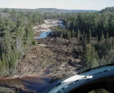
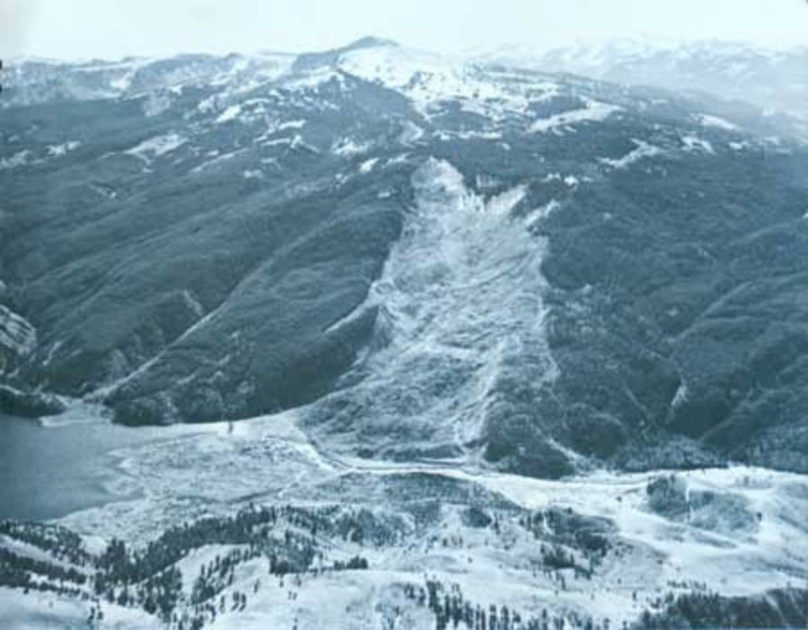
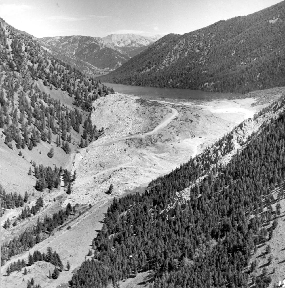
Quake Lake (Montana, 1959)
On August 17, 1959, a 7.5M earthquake hit the Madison River area in southwest Montana. A landslide weighing 80 million tons was triggered and traveled down Sheep Mountain at an estimated 100 mph. A total of 28 campers in the area were killed. Five miles upstream at Hebgen Lake, seiche waves nearly failed Hebgen Dam. The 250-foot-thick landslide fan immediately began to impound the river at the landslide site. The U.S. Army Corps of Engineers were mobilized in a major emergency construction project to build a new spillway through the landslide debris³. The lake is still impounded by the landslide today.
Glacial Ice
Glacier movement can cause at least nine kinds of ice-dammed lakes [1]. For example, glaciers moving downstream in a main valley can block tributaries. Tributary glaciers moving downstream can block main valley watercourses. Failure can occur once the lake has reached a high level to overtop the glacier or erode an ice tunnel under or through the glacier.
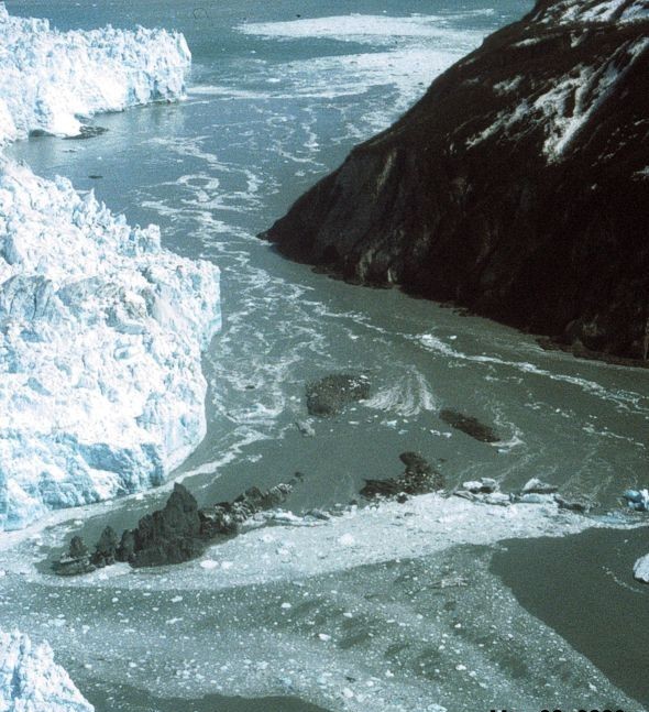
Hubbard Glacier and Russell Fjord (Alaska, 1986)
There have been multiple incidences of Hubbard Glacier advancing downstream and blocking the outlet of Russell Fjord, creating a dam that formed “Russell Lake.”

In one instance in 1986 after the Hubbard Glacier advanced, the new lake filled with runoff, its water level rising to 83 feet. This caused a decrease in salinity levels that threatened its marine life. Around midnight on October 8, 1986, the dam began to give way. In the next 24 hours, an estimated 500,000 acre-feet of water gushed through the gap, and the fjord was reconnected to Disenchantment Bay, returning to its previous level4.
Glacial Lake Outburst Floods (GLOFs)
Natural moraine dams are formed in steep mountain areas affected by the advance and retreat of valley glaciers in the past few centuries¹. These moraine dams have steep slopes, consist of unconsolidated material, and are vulnerable to overtopping or internal erosion. In a different process, ice can also form glacial dams/lakes that may cause its reservoir to fill and fail yearly. When these dams release water through total or partial failure, the event is termed a Glacial Lake Outburst Flood or GLOF. Glacier icefalls or steep mountain rockfalls can fall into glacial lakes, creating large waves that overtop and fail moraine dams. One study found that there have been 1,348 GLOF events in 20 countries in the last ten centuries5. The performance of moraine dams is unpredictable, and they can cause major damage to downstream areas when they fail. The floods can contain boulders, sediment, debris, and logs with devastating impacts downstream. The melting and thinning of glaciers from climate change has increased the size of glacial lakes and caused new lakes to form, increasing the frequency of GLOFs 6,7. GLOFs have occurred in Alaska, Canada, Pakistan, Peru, China (Tibet), and Nepal. Peru has had a program for assessing and addressing GLOF risks for decades. Mitigation projects have included pumps, siphons, and construction of spillways and tunnels.
Dig Tsho GLOF On August 4 4, 1985, Dig Tsho, a moraine-dammed glacial lake in Nepal, burst after an ice avalanche triggered a wave that failed the dam. The volume of water released was between 4,800 and 8,000 acre-feet7. The flood destroyed a hydroelectric power plant, 14 bridges, and about 30 houses. Tragically five persons were killed.
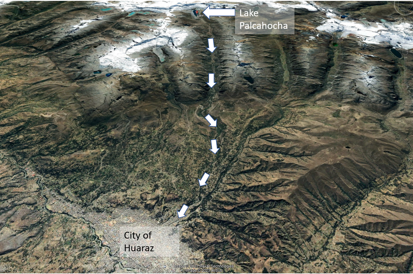
Lake Palcacocha GLOF (Peru, 1941)
The Cordillera Blanca Mountain Range in Peru has been the location of the highest loss of life from GLOF events. In 1941, an ice avalanche triggered the failure of the moraine dam at Lake Palcahocha (elevation 15,000 feet). The flood killed an estimated 4,000 people in Huaraz, a third of its population at the time8.
Avalanche Dams
Similar to landslides, rivers can be impounded when a large avalanche occurs.

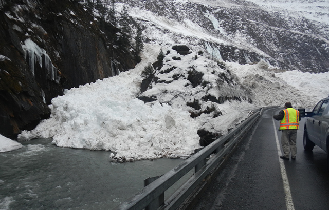
Valdez Avalanche Dam (Alaska, 2014)
On January 24, 2014, after 12 inches of rain and warm temperatures, several avalanches occurred near Valdez, Alaska. The largest avalanche blocked Lowe River, forming a half-mile-long lake 30 feet deep. The avalanche blocked Valdez’s only road access to the rest of Alaska. It was dubbed by locals as a “Damalanche.” State DOT staff were mobilized from across the state to remove over 200,000 cubic yards of ice. Access was restored after 12 days.
Ice Jams
During winter in cold regions, rivers can form thick covers of ice. During the spring warmup, this ice can begin to move downstream. Where the ice encounters obstructions (bridges) or other constrictions (bends), the ice blocks can pile up, forming ice jams. These jams can cause 1) lateral and upstream flooding as the jam backs up water and 2) flooding downstream when the ice jam breaks. The U.S. Army Corps of Engineers maintains a database of 18,000 ice jams in the U.S.9. For more on ice jams and mitigating risks, see the DamFailures.org lessons learned: Dams in cold weather regions should account for ice.
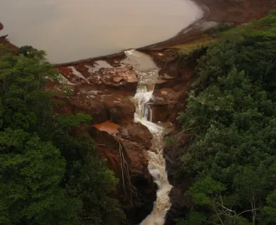
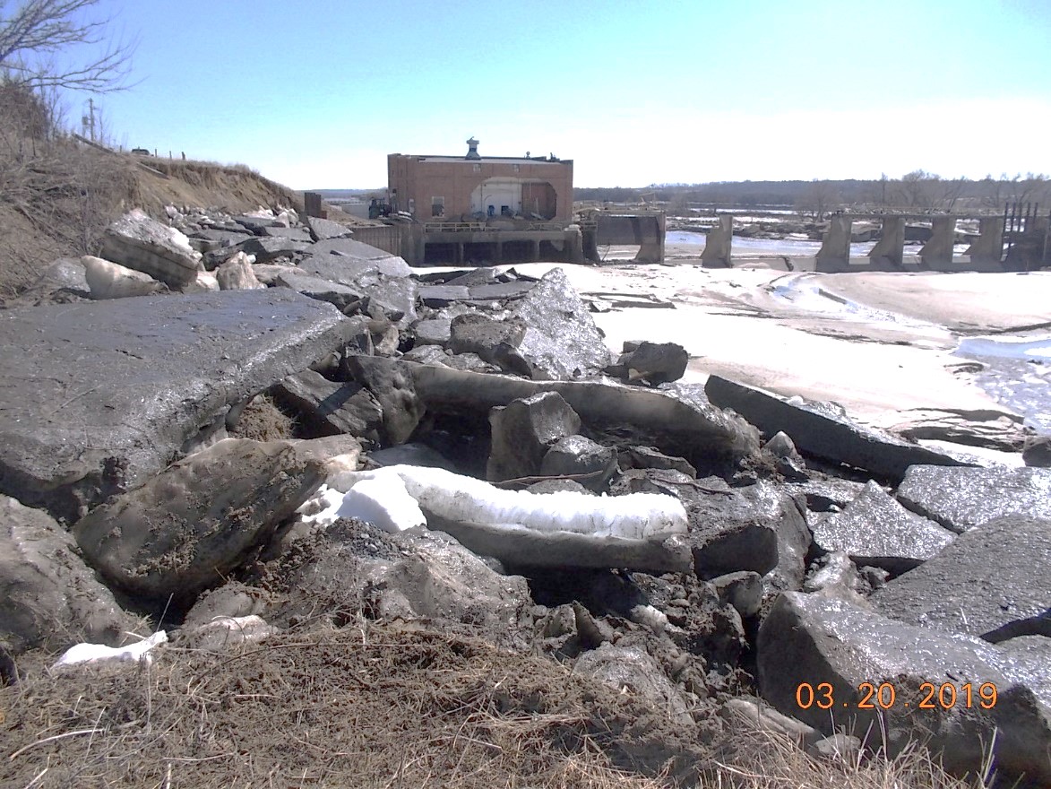
Spencer Dam Failure (Nebraska, 2019)
In March 2019, after a cold winter and a foot of snow, a bomb-cyclone event hit the Midwestern Plains of the U.S. Because of the high precipitation, snowmelt, and frozen ground conditions, the Niobrara River in northern Nebraska received substantial runoff. The 2-foot-thick river ice floated in the flood water, broke into large slabs, and floated downstream. Numerous ice jams occurred. One large ice jam formed upstream of Spencer Dam – an embankment dam with a concrete/powerplant spillway structure. The jam created a large body of water, and when it was released, Spencer Dam quickly overtopped and failed, causing the loss of one life.
References:
(4) NASA Earth Observatory. The Advance of Hubbard Glacier.
This lesson learned was peer-reviewed by Dan Jantzen, Butwal Paxman Group, LLC.


Hebgen Dam (Montana, 1959)

Spencer Dam (Nebraska, 2019)


The Formation and Failure of Natural Dams