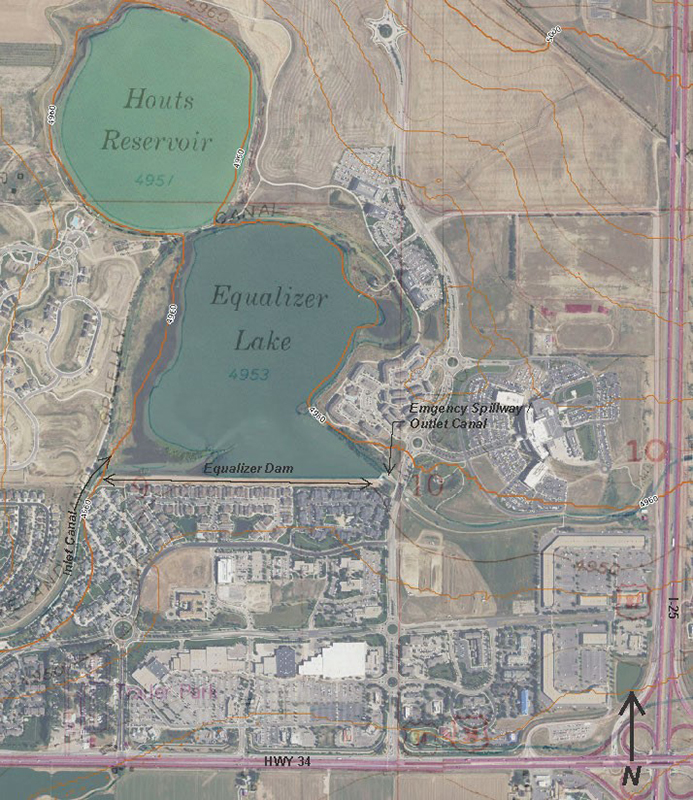
The Equalizer Lake Dam is owned by the Greeley Loveland Irrigation Company (GLIC) and is located in Larimer County, Colorado approximately 50 miles north of Denver. GLIC operates and maintains a fifty mile long canal system, and four off channel reservoirs that supply water for agriculture and municipal uses that is diverted from the Big Thompson River. This dam was completed in 1902 and has a dam height at the maximum section of 20 feet, and normal storage volume of 1,139 acre-feet of water. The embankment consists of homogeneous earth fill composed of silty clays (CL). The contributing basin that drains into the reservoir is approximately 1,345 acres. As of August 2019, the dam was in satisfactory condition. It was rehabilitated in 1999, which included upgrading the spillway and rehabilitation of the embankment slopes to repair erosion damage and improve slope stability.
Dams in Colorado are regulated by the Colorado Division of Water Resources, Office of the State Engineer. The State Engineer’s Office defines the Hazard Classification of a dam as the placement of a dam into one of the following categories based on the hazard potential if a “Sunny Day” failure of the dam were to occur at full reservoir level:
- Low hazard: A dam for which minor damage to property with no anticipated life loss is expected.
- Significant hazard: A dam for which significant property damage is expected but no loss of life is expected.
- High Hazard Dam: A dam for which loss of human life is expected to result from failure of the dam.
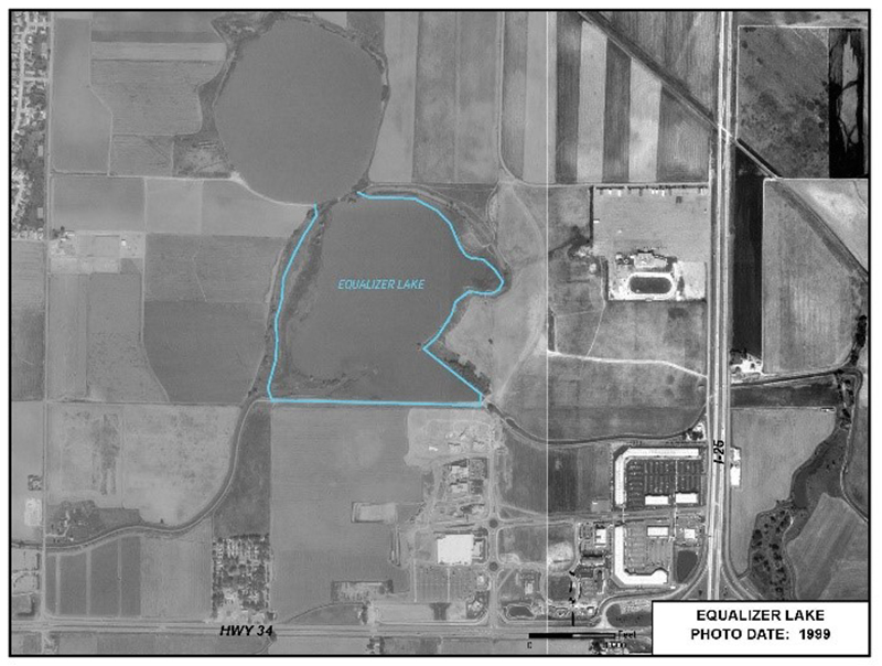
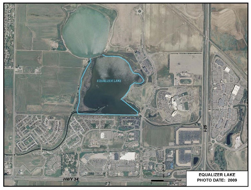
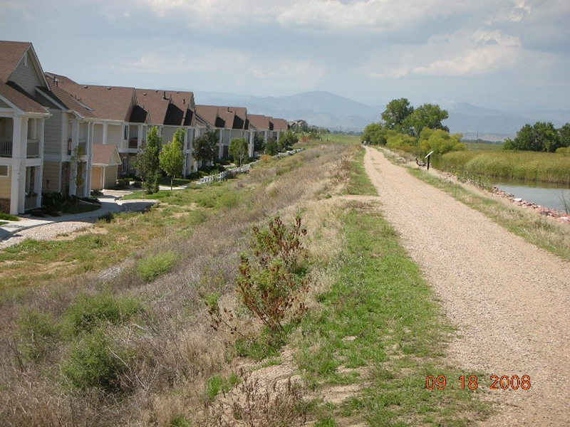
Up until the late 1990’s, the reservoir located east of the City of Loveland along U.S. Highway 34 had little downstream consequences if a failure of the dam were to occur and was classified as low hazard. As growth in Northern Colorado boomed in the early 2000’s, the agricultural land below the Equalizer Lake Dam was developed into commercial, retail, and multi-family properties, which included a multi-family apartment complex along the toe of the dam (see photos). As a result of the increased hazard potential of this dam due to the downstream development, the hazard classification was changed by the State Engineer’s Office in 2009 from low hazard to high hazard. This once low hazard dam is now required to meet high hazard standards which include increased inspection and monitoring frequency, and flood routing capacity requirements.
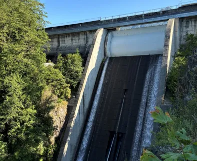
The emergency spillway is a 20-foot wide concrete overflow weir that passes storm flows from the reservoir into the GLIC canal. The spillway has the capacity to route the 100-year flood (1 percent annual chance flood) which meets the inflow design flood criteria for a low hazard dam. With re-classification to high hazard, the spillway must have the capacity to pass a flood generated by the probable maximum precipitation (PMP) rainfall event. The alternatives for the owner are to construct a spillway large enough to pass the high hazard inflow design flood, or remove the dam and rebuild the canal through the reservoir basin.

Removal of the dam is not an acceptable option for the owner or community surrounding Equalizer Lake since it has become a center point of the development with recreational and ecological benefits. A consultant was hired to evaluate the hydrology in the contributing drainage basin and determine alternatives for an acceptable spillway. A significant design constraint is that storm water outflows must be returned back to the natural water course per the Colorado Dam Safety Rules and Regulations. This means the dam cannot be raised to provide increased head for the spillway as this would back water into the inlet canal and cause flooding along the canal during routing of the inflow design flood. Additionally, the spillway crest cannot be lowered as it flows into the GLIC ditch and operational elevations are tied to the ditch invert.
The 2003 alternative analysis by Boyle Engineering determined 375 feet of additional spillway width would need to be constructed to meet the high hazard standards. An incremental damage analysis was also performed to determine if a smaller spillway size could be justified. A reduction in the spillway size would be acceptable if the incremental damage analysis showed no additional life loss or property damage would occur when comparing the overtopping failure flood to a base flood assuming the dam were not in place. The analysis did not result in a smaller inflow design flood being acceptable for spillway sizing due to the very short distance from the dam to the dense downstream development.
Through the above alternative analysis, the costs of modifying the spillway to pass the PMP rainfall event was determined to be cost prohibitive to construct at this site. Overtopping protection of the downstream face of the embankment was also evaluated as part of the 2003 study. Although overtopping protection does not prevent the floodwaters from damaging the downstream development, it would prevent the dam from failing due to erosion of the downstream slope if flood waters overtopped the embankment. For overtopping of the embankment to be considered for approval by the State Engineer’s Office as a routing alternative, the design must demonstrate that erosion during the inflow design flood will not result in a breach of the dam, and overtopping would only occur during rare events with the more frequent storm events routed down the historical flow path (GLIC Ditch). Two alternatives were evaluated using buried roller-compacted concrete or articulated concrete blocks along the length of the embankment to armor the downstream slope and crest against erosion during overtopping events. The cost of these alternatives came in at over $2 million based on the 2003 study.
Since the 2003 report, the owner has been making slow progress to resolve this issue. Additional alternatives have been considered including reconfiguration of the reservoir into several small interconnected ponds with a combined volume similar to the existing reservoir, or relocating the dam farther into the existing lake allowing for a very mild downstream slope that would provide green space/park opportunities and reduce flood velocities and erosion potential during a large overtopping flood event. This alternative would maintain most of the current storage volume and would provide a more appealing environment than a concrete spillway structure. The owner is working with the City of Loveland and other partners on these alternatives that could create more trails, wildlife viewing, and park opportunities.
The owner’s engineer is developing these alternatives and plans to complete preliminary designs in 2020. The spillway enlargement project will be reviewed and approved under the Colorado Dam Safety Rules and Regulations that are scheduled to be adopted in the fall of 2019. The new Colorado/New Mexico Regional Extreme Rainfall study was recently developed to determine the PMP rainfall and may result in a reduction of the PMP rainfall amounts, a decrease in overtopping, and possible cost reduction. This case study will be updated as the final alternative is decided upon by GLIC, McWhinney Enterprises (developer), and other partners.
References:
(1) Boyle Engineering Corporation. (2003). Equalizer Dam Spillway Alternatives Study.
(2) Franz, J. (2013). Equalizer Spillway Design Criteria Memo. Colorado Dam Safety.
(3) Colorado Dam Safety. (2019). Draft Rules and Regulations for Dam Safety and Dam Construction.
This case study summary was peer-reviewed by Ryan Schoolmeesters, P.E., Colorado Division of Water Resources.


Lessons Learned

High and significant hazard dams should be designed to pass an appropriate design flood. Dams constructed prior to the availability of extreme rainfall data should be assessed to make sure they have adequate spillway capacity.
Learn more
The hazard classification of a dam can change over time (hazard creep).
Learn moreAdditional Lessons Learned (Not Yet Developed)
- Hazard creep can have significant impacts on a dam owner. Low hazard dams that are upgraded to high hazard are impacted the most as they typically have spillways designed for smaller inflow design flood events and upgrading the spillway is costly.
- Dam owners need to pay close attention to plans for future development below their dams and work with regulatory agencies to reduce impacts to the dam.
- County and City Planners need to recognize the impacts new development can have on dams and work with State dam safety officials when developments below dams are being reviewed.
- Regulatory agencies and dam owners need to remain vigilant to the consequences of a dam failure and incorporate engineered solutions to mitigate those potential consequences.
- Since low hazard dams are often inspected less frequently by State dam safety programs, hazard creep can occur without being noticed.

Appurtenant Structures for Dams (Spillway and Outlet Works) Design Standards