The September 2013 rainfall that occurred on the Front Range of Colorado was the result of an unusual, late season storm event where warm moisture and upslope winds allowed this regional storm to dump up to 17 inches of rain over a seven day period. It has been reported (Doeskin, 2014) that this storm ranked in the top three extreme storms documented in Colorado. The rain event did not have unusually high rain intensity, but did have a long duration and high volume which caused extensive flooding. By most accounts, the rainfall and flooding occurred simultaneously from Colorado Springs in the south to Fort Collins in the north and impacted numerous dams at the same time. This case study provides a time line for the events that occurred and the Colorado Dam Safety Branch’s response to this extreme storm event.
Although the rainfall and resulting flooding that occurred September 8 - 18, 2013 along the front range of northern Colorado is considered extreme, it was below what would be termed a Probable Maximum Precipitation (PMP) event. In the impacted area, the Hydrometeorological Report (HMR) 55A predicted PMP rainfall is on the order of 30 to 40 inches over a period of 72 hours. The maximum measured rainfall for the September 2013 storm was in Boulder, CO at 20 inches of rain over the 10 day period. As a result, the high and significant hazard dams within the affected area performed as designed and were not considered in danger of failing due to overtopping. However, the 100-year, 24-hour rainfall used for design of spillways for low hazard dams in the affected area is typically in the range of 4 to 6 inches. During the course of the storm, the peak 24-hour rainfall over much of the affected area was in the range of 6 to 10 inches. It is therefore not surprising or unexpected that small, low hazard dams overtopped and failed as the rainfall and runoff exceeded the design capacity of their spillways. The official count of low hazard dams that failed during the September 2013 event stands at nine.
Dams in Colorado are regulated by the Colorado Division of Water Resources, State Engineers Office (SEO). The Colorado Dam Safety Branch (DSB) of the State Engineer’s Office is made up of twelve dam safety engineers (DSE’s) spread geographically throughout the state that are responsible for the inspection and regulation of more than 1,700 program dams located within seven water divisions. The SEO defines the Hazard Classification of dams in the state and places them into one of the following categories based on the potential consequences of a “Sunny Day” failure at full reservoir level:
- Low hazard: A dam for which minor damage to property with no anticipated life loss is expected.
- Significant hazard: A dam for which significant property damage is expected but no loss of life is expected.
- High Hazard Dam: A dam for which loss of human life is expected to result from failure of the dam.

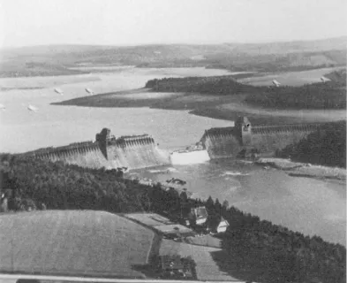
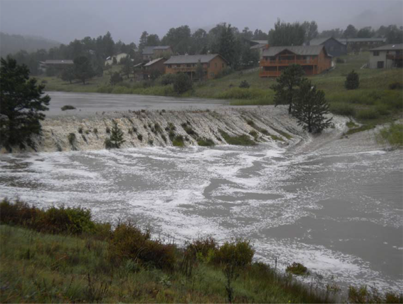
The storm began as steady light rain on September 9th, resulting in wet antecedent moisture conditions in the region. The first period of high-intensity rain occurred from Wednesday night on September 11th into Thursday morning of the 12th with the first reports of impacted dams coming at 2:11 am on Thursday, September 12, 2013. Larimer County emergency managers issued warnings and then sent requests for assistance in response to rainfall, flooding and “small dams failing.” By the morning of September 12th, emergency management agencies from Colorado Springs to Fort Collins were in response mode. Photo 1 shows the extent and magnitude of the rainfall event.
Given the limited access due to the road closures, DSE’s were busy calling dam owners and DWR water commissioners, gathering reports on the status of structures, reviewing conditions that required observation, and briefly reviewing emergency action response. The owners of the high and significant hazard dams reported overall the dams were functioning well. The reservoirs were filling but no alarming conditions were observed. Low hazard dams were also filling and were likely to start spilling soon. DSE’s continued to work the phones and by Thursday afternoon the majority of dam owners had been reached.
In addition to responding to requests for information and reaching out to dam owners, members of the Dam Safety Branch engaged early on with the Emergency Operations Centers (EOC) at State and County levels to become plugged into and assist the emergency response community. The DSB’s presence at the EOC’s allowed for direct communication with emergency managers at both the county and state levels and provided both a technical resource for interpreting general and specific dam safety risks and knowledge of dam structures and operations for verification of information being disseminated to the EOC’s, media and general public. Additionally, being plugged into the emergency management community gave the Dam Safety Branch (DSB) access to the full state and federal resources being applied to the emergency. Through the EOC’s, the DSB was able to make resource requests for things such as air transport to inaccessible sites for inspection, heavy equipment to clear spillways and lower reservoir levels, and in some cases perform controlled breaches of unsafe structures. The integration into this community proved to be a critical part of the response.
An unanticipated concern that arose was uncontrolled inflow into many of the off-stream reservoirs in the impacted area. Many reservoirs and dams along the Front Range are off-channel and filling is controlled by gated diversion structures on the rivers or streams. Water is delivered to the reservoirs via ditches that run cross-county, in some cases for miles between the stream diversions and the reservoirs. Given the level of control over the inlet ditches, the spillways of these reservoirs rarely, if ever, spill. The widespread flooding overnight on Wednesday and into Thursday damaged or destroyed numerous diversion structures along the streams, allowing uncontrolled inflows into irrigation ditches and causing reservoir levels to rise uncontrolled. In some cases, the ditches themselves failed due to the increased flow exceeding the capacity. This resulted in unanticipated flooding of developed areas downstream of the ditches. Where ditches remained intact, the receiving reservoirs filled and began to spill. In numerous cases, water flowing from spillways for the first time in anyone’s memory led uninformed residents to panic and report that the dams were failing. Communication between DSE’s, dam owners, ditch owners and water commissioners was essential to confirm or dispel these reports.
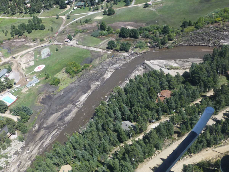
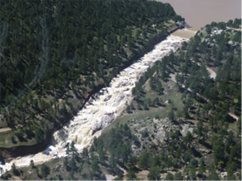
By mid-day of September 12th, there were reports of five (5) low hazard dams in the Big Elk Meadows community that were overtopping and near failure. The same day, the Carriage Hills reservoirs within the town limits of Estes Park were reported to be overtopping and damaged (see Photos 2 and 3). Baseline Reservoir located near the eastern limit of the City of Boulder is impounded by two high hazard dams and was filling at an uncontrolled rate due to a failed inlet structure on South Boulder Creek. The rapid filling combined with embankment saturation from the rain itself caused instabilities on the downstream slope of the Northwest Dam where a 40-foot long, 1-foot deep slump at the downstream shoulder occurred. Initial mitigation actions taken by the owner to minimize continued destabilization of the slope included improving crest drainage toward the upstream slope (away from the downstream slump), covering the downstream slope with tarps to minimize continued slope saturation, and establishing makeshift around-the-clock monitoring systems to quickly detect future slope movement. Due to quick action of the owner and engineers, the dam was able to “weather the storm.” Digitally accessible state dam files and the 24-hour monitoring and inspection were huge contributors to the successful outcome of a stressful situation. This situation has also highlighted another potential failure mode that should be considered when evaluating dam designs: intense, sustained rainfall leading to increased pore water pressure in the downstream shell, resulting in slope instability.
On Friday, September 13th (Day 2), the full effect of the flood hit the front range with the rainfall reaching 100-year and greater return intervals over multiple areas. Many of the major arterial highways along the foothills were closed including Interstate 25 which is a main north-south artery. The morning news reported the imminent failure of Blunn Dam in a suburb of Denver, CO. A quick investigation revealed the emergency spillway was flowing and functioning properly and the dam was not in danger of overtopping. Unfortunately, multiple similar misinformed reports were shared by the media leading to unnecessary panic on the part of the public. DSE’s rushed to confirm and clarify incident reports as well as respond to continuous requests for information coming from many avenues including the Governor’s Office. Between chasing down false messages in the media, providing rapid public education, and responding to urgent requests for information, it quickly became clear just how critical effective communication is during emergency response to a flooding event.

By Monday morning September 16th (Day 5), the rainfall intensity had decreased and the system was beginning to catch up allowing roads to re-open. DSE’s continued to respond to reports of incidents, check the dams whose spillways were operating, and report the status back to the emergency managers. By this time, the low hazard dams that overtopped on Days 1 and 2 had failed including five dams at Big Elk Meadows, Carriage Hills #2 in Estes Park, Havana Street Dam in Commerce City, and the Emerald Valley dams (2) in Colorado Springs.
Around this time, a National Guard helicopter pilot flying missions to rescue stranded citizens noted significant flow over the emergency spillway for the Ralph Price Reservoir (also known as Button Rock Dam). This reservoir is located on North St. Vrain Creek that serves as a water source for the City of Longmont, CO. During the peak of the storm, approximately 10,000 cfs flowed through the emergency spillway and into the Town of Lyons, CO, causing devastating damage. There was no reliable information available to confirm the condition of the dam as road access was not possible and the dam’s caretaker was evacuated from the site in the midst of the storm. A helicopter flight was coordinated by the Emergency Operations Center to evaluate the condition of the dam and spillway. On Monday September 16th, representatives from FEMA, the City of Longmont, and the Colorado Dam Safety Branch were flown to the site to assess the condition. Based on review of the geology and spillway design drawings and visual examination of the concrete spillway structure and downstream rock channel from the air, it was determined the channel was well armored by bedrock and performing as designed. This helicopter reconnaissance mission and many more like it to other inaccessible areas along the Front Range were invaluable in rapidly investigating conditions, and informing emergency managers and the public.
With continued requests for participation in the EOC’s, reported incidents continuing to require response, and a daunting number of dams (over 200) that needed emergency inspections, Colorado Dam Safety Branch Chief Bill McCormick saw his staff of 11 DSE’s being stretched to their limit. A meeting was held with respected members of the dam safety community in the Denver area to discuss the practicality and necessity of using volunteer engineers to perform rapid emergency inspections of dams in the impacted area. The concerns regarding first fill and pool of record conditions and rainfall beyond design standards were the primary drivers that prompted emergency dam inspections.
As clear tasks and responsibilities related to the Engineer Inspection Program begin to emerge, a tool developed by a local meteorological consultant was used as the prioritization scheme to determine which dams needed to be inspected. The tool calculated an estimated precipitation index (EPI) for the rainfall that occurred and the inspection criteria was developed. This included: low hazard dams with EPI > 25-years, significant hazard dams with EPI > 50-years, and high hazard dams with EPI > 100-years. A list of 207 dams meeting the above criteria and therefore in need of emergency inspection was developed.
On Friday, September 20 (Day 9) after the successful completion of an orientation meeting, the Engineer Inspection Program began. The volunteer group consisted of 113 volunteer engineers from 27 engineering consulting firms, four federal agencies, and one state agency went to work. This effort proved to be a huge success as a high percentage of emergency inspection condition assessments were completed within six days of the initial kick off meeting. The Dam Safety Branch was able to confidently report to state leadership, the emergency management community, and the citizens of Colorado that all identified and inspected dams were safe and recovery work could commence without the threat of dam failure. Incidents that did occur at high and significant hazard dams were most commonly caused by embankment saturation due to the heavy and sustained rain and uncontrolled inflow from irrigation ditches. This was a clear validation of the regulatory design review process that is intended to ensure that dams in Colorado are designed and built safely.
The nine dams that failed during the event were considered small or non-jurisdictional structures with low hazard ratings. Their spillways were appropriately sized according to design standards for the 25- or 50-year events. The rainfall that occurred between September 9th and 18th, 2013 far exceeded these design criteria. Follow-up studies showed the impacts of these dams failing during the flood event caused no more damage than the flood event had already caused, validating their hazard classification.
The 2013 flooding event was the 7th historic flood in Colorado since 1902, suggesting a frequency of about once every 16 years. This suggests that every dam safety engineer planning on a career of 20 years or more can reasonably expect to be involved in such an event and therefore should prepare for it. It is our hope that other state dam safety programs will take the lessons and information from our shortcomings and successes and do their best to protect the safety of their citizens the next time a historic flood event occurs.
References:
(2) Colorado Dam Safety Branch (2014). Report of the September 2013 Little Thompson River Flooding and Big Elk Meadows Dam Failures. Colorado Division of Water Resources.
(3) McCormick, B. (2013). Colorado Dam Safety 2013 Flood Response.
This case study summary was peer-reviewed by Bill McCormick, P.E., P.G. (Colorado Dam Safety Division).


Lessons Learned

Downstream flooding can be caused by spillway flows that exceed channel capacity or as a result of reservoir misoperation.
Learn more
Dozens of dams can fail or be in danger of failing during a single event (i.e. swarming failures). Dam owners and regulators need to prepare for these types of events.
Learn more
Extreme floods do occur.
Learn more
Floods can occur due to unusual or changing hydrologic conditions.
Learn more
Hazardous hydraulic conditions, such as hydraulic rollers, can occur at dams of all sizes.
Learn more
High and significant hazard dams should be designed to pass an appropriate design flood. Dams constructed prior to the availability of extreme rainfall data should be assessed to make sure they have adequate spillway capacity.
Learn more
Intervention can stop or minimize consequences of a dam failure. Warning signs should not be ignored.
Learn moreAdditional Lessons Learned (Not Yet Developed)
- Large dams that were subject to more stringent design standards functioned as intended and did not fail. Incidents that did occur at these dams were typically caused by embankment saturation due to heavy sustained rain and rapid filling. Smaller dams proved to be the biggest safety concern due to spillways that were sized for smaller events.
- A low hazard structure rating does not mean no hazard.
- Promote internal awareness of resources available through the emergency management network and the process for garnering these (e.g. resources request process for access to heavy equipment, communication radios, transportation, etc.).
- Develop ways to interface more with emergency managers, e.g. inviting them on inspections of high hazard dams, participating in Emergency Action Plan exercises.
- Relationships were huge: within the branch, with DWR water commissioners, with past DWR employees, with local engineers, with the meteorological community, with dam owners and caretakers, and with emergency managers at state and local levels.
- Maintain current contacts for non-jurisdictional dams in dam inventory databases.
- Hold more regional/basin-wide dam safety exercises and discussion to educate owners and emergency managers on dam safety and emergency actions plans.
- Have a designated Public Information Officer (PIO) in the case of a widespread emergency to handle media requests, public inquiries, etc. while dam safety personnel are able to focus on the situation.

A Guide to Public Alerts and Warnings for Dam and Levee Emergencies

Appurtenant Structures for Dams (Spillway and Outlet Works) Design Standards

Colorado – New Mexico Regional Extreme Precipitation Study Volume III

Colorado – New Mexico Regional Extreme Precipitation Study Volume VI