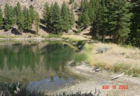
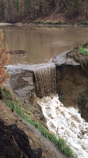
Hawkins Dam impounds Wenner Lake No. 1, the most downstream reservoir in the Wenner Lakes chain of manmade lakes located 6 miles Southeast of Twisp, WA in Okanogan County. The dam is a 35-foot high earthfill dam with a crest length of 350 feet and impounds a 4-acre reservoir with a volume of 22 acre-feet. It was rated as a significant hazard project because of two residences and a state highway located downstream. The principal spillway was a drop-inlet that consisted of a 12-inch diameter riser pipe with a 15-inch diameter outlet pipe. An unlined, two-stage open channel emergency spillway was excavated through the right abutment. This spillway had a pilot channel with a 30-foot width and an invert elevation 4.3 feet below the dam crest. A fuse plug section was provided between the right end of the dam and the pilot channel, with a top width of 60 feet and a top elevation 3.3 feet below the dam crest. The fuse plug section had a buried concrete erosion cutoff wall at the entrance to prevent erosion into the reservoir. This cutoff wall did not extend across the pilot channel. The spillway channel downstream was founded in native soils and was unlined.
The drainage area upstream from Hawkins Dam in Finley Canyon is 17.2 square miles. However, the upper 10.3 square miles of Finley Canyon are non-contributing due to a large natural depression that could impound thousands of acre-feet before it would overtop the berm.
In mid-July 2014, lightning started several forest fires that eventually combined to form the Carlton Complex Fire. The Carlton Complex Fire eventually burned more than 256,000 acres in southwest Okanogan County, one of the largest forest fires in Washington State history. The burned area included most of the Finley Canyon watershed and the downstream Benson Creek Watershed. On the evening of Thursday, August 21, 2014, starting at about 6 pm, the sub-basins within the Benson Creek watershed received from 0.4 to 0.9 inches of rain in a one-hour period and 0.8 to 1.0 inches in slightly over 2 hours. High runoff flows and numerous mudslides occurred throughout the area. By Friday morning, State Highway 153 was closed 6 miles south of Twisp, two of the five dams in Finley Canyon had failed, and a third dam had partially failed.

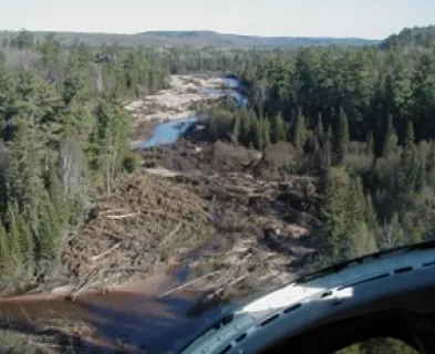
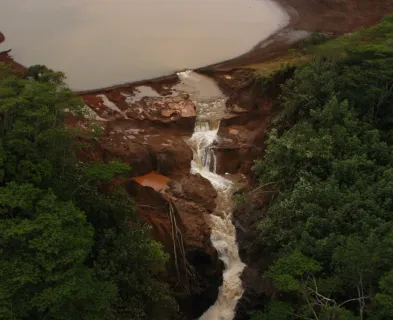
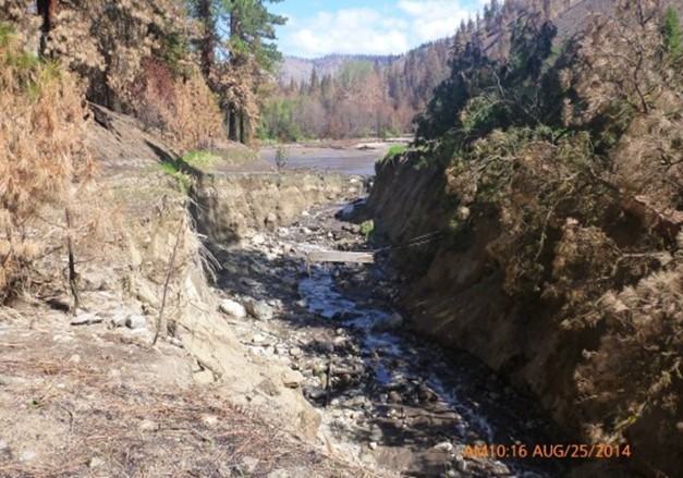
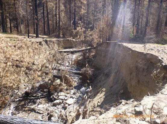
Upstream in Lower Finley Canyon, high runoff flows in conjunction with spillway blockages resulted in overtopping of the dams at Wenner Lake Nos. 1 through 4. At Rabel Dam (Wenner Lake No. 2), a debris flow from the hillside blocked the spillway, but fast action by the owners reopened the spillway in time to prevent further damage. At Hawkins Dam, a debris flow from the hillside above the right side of the dam may have partially blocked the spillway, but there was no indication that the dam overtopped. However, erosion in the unlined spillway channel headcut from an initiation point downstream all the way back into the lake, draining the 22 acre-foot volume of storage. Erosion in the Hawkins Dam spillway scoured a channel 360 feet long, ranging in width from 18 to 45 feet wide and ranging in depth from 8 to 18 feet deep, with an estimated volume of about 6,600 cubic yards. Based on photographs, it does not appear that the fuse plug section activated. Rather, the erosion was concentrated along the 30-foot-wide pilot channel. Despite the erosion, the emergency spillway succeeded in preventing the dam from overtopping and reducing the peak discharge that might have happened had the dam itself failed. Fortunately, as noted by Okanogan County Emergency Management, there were no fatalities, injuries, or missing persons from this flooding. The failure of Hawkins Dam caused some sheet flooding and deposited a large debris fan adjacent to a seasonal cabin at the mouth of Finley Canyon before discharging into the Benson Creek. Further downstream, the combined flood flows from Benson Creek and Finley Canyon resulted in the washout of State Highway 153.

Why did the relatively modest storm of August 21st cause so much damage to the dam? Rainfall calculations by the National Weather Service (NWS) Spokane office and by the Department of Ecology’s Dam Safety Office (DSO) indicate the rainfall on Finley Canyon and the Benson Creek watershed was on the order of only a 5-year event. To better understand this event and why it caused such damage, the DSO compiled a rainfall-runoff model in HEC-HMS to estimate what may have happened. The DSO modeled pre-fire and post-fire conditions. Key input parameters included rainfall hyetographs derived from NWS radar data, USBR unit hydrographs, and infiltration rates which were modified by the burned area coverage and severity. The pre-fire model was calibrated to USGS regression equation peak flows for the 25-, 100-, and 500-year events using the USGS StreamStats online program.
Model predictions by the DSO were that the peak flow at the most upstream facility, Chalfa Dam (Wenner Lake No. 5), was 294 cubic feet per second (cfs), and the dam may have been overtopped for as long as 4 hours, and by as much as 6 inches. The peak flow at Rabel Dam was 332 cfs, and its dam may have been overtopped for up to 9 hours, and by as much as 7½ inches. At Hawkins Dam the model predicted peak flow below the dam of about 360 cfs. With the spillway breach, the peak flow was estimated at about 600 cfs, with the release of 22 are-feet of stored water, an increase in peak flow of 67%. Moving downstream the combined peak flow from Finley Canyon and Upper Benson Creek was 1080 cfs and the peak flow at SR-153 was on the order of 1220 cfs. These results were then compared to a pre-fire watershed model and the estimated flows from the August 21st event were 7 to 8 times larger than the predicted flows from a 1000-year local storm event.
Why the huge increase in flows? Post-fire infiltration rates were significantly lower than the natural, pre-fire infiltration rates. The pre-fire surface infiltration rates ranged from 1.78 to 1.95 inches per hour, while the post-fire surface infiltration rates used in the model ranged from 0.07 to 0.20 inches per hour. The Burned Area Emergency Response (BAER) Team also studying the Carlton fire area calculated that the SCS Curve Number values for Finley Canyon increased from a curve number 0f 44.5 pre-fire to a curve number of 70 post-fire.
As a result of this flood and the failure of Hawkins Dam, the DSO developed Recommended dam safety protocols for burned watershed hydrology calculations. The spillway breach at Hawkins Dam was repaired in 2017 by backfilling the eroded channel and installing a gabion-lined erosion protection, and the reservoir was refilled.
References:
(6) Johnson, D.L., & LaVassar, J. (1997). First Periodic Inspection Report, Hawkins Dam, Rabel Dam, and Chalfa Dam (Wenner Lakes Nos. 1, 2 and 3), Memorandum to File. Department of Ecology.
This case study summary was peer-reviewed by Mark Baker, P.E., DamCrest Consulting.


Lessons Learned

Floods can occur due to unusual or changing hydrologic conditions.
Learn more
Many earth-cut spillways have been constructed in erodible material that can result in unsatisfactory performance and breaching of the spillway
Learn moreAdditional Lesson Learned Information
- Wildfires change the conditions of a watershed, such as infiltration, how fast water can move, and how vulnerable the land surface is to erosion.
- Heavy rains in a burned area can create:
- More and faster runoff from rainfall events, especially high-intensity storms;
- Large amounts of sediment, which may reduce storage capacity in the reservoir;
- Debris flows (mudslides) or downed timber, which may obstruct access to the dam;
- Debris flows from hill slopes near spillways, which may obstruct spillways;
- More floating debris (dead trees, branches, sticks) in the reservoir, which may obstruct spillways and damage the face of the dam.
- Considerations for reducing risk to dam safety from a burned watershed:
- Log-boom or other barrier to divert floating debris;
- Treatments in the watershed to capture or slow runoff and debris flows;
- Diversion berm to divert debris flows from adjacent hill slopes;
- More robust erosion cut-off features or other armoring to resist erosion of the spillway channel.

Burned Area Emergency Response (BAER) Report


Hydrologic Analyses of Post-Wildfire Conditions