Earth-cut auxiliary spillways are excavated through natural soil and/or rock materials, normally protected with vegetation. The Natural Resources Conservation Service (NRCS), formerly the Soil Conservation Service (SCS), assisted local sponsors in constructing more than 29,000 dams throughout the United States, most of which are equipped with an earth-cut auxiliary spillway. Many other dams outside of the NRCS purview have also been constructed with earth-cut spillways. Earth-cut auxiliary spillway geometry typically consists of a trapezoidal open channel with a subcritical inlet, a level crest or control section, and a supercritical exit.
The purpose of an auxiliary spillway is to safely pass major flood flows around the dam and prevent overtopping of the dam embankment. Most earth-cut auxiliary spillways were designed more than 50 years ago using general guidelines and engineering judgment without a rigorous analysis of their erodibility for the maximum design storm. Unfortunately, some designs underestimated the erodibility of the spillway. As more and more earth-cut auxiliary spillways are activated, some have performed as designed while others have sustained significant erosion, and a few have completely breached.

At the time that many of the NRCS dams were constructed, the spillway design criteria allowed significant damage to the auxiliary spillway to occur provided activation was infrequent, the flow duration was relatively short, the crest of the auxiliary spillway was not breached, and the dam embankment was not compromised. The general practice was to locate the spillway at either dam abutment and configure the spillway to minimize flow concentrations and limit flow velocities. The spillway was also located, to the extent possible, to take advantage of zones of earth or rock material that are erosion resistant with respect to the anticipated flow conditions. At some dams, complex site conditions presented designers with significant challenges, resulting in deviations from recommended practice. In other cases, alterations have been made to the spillways that make them more susceptible to erosion. Deviations from design guidelines to fit the spillway into challenging topographic site conditions can adversely impact spillway performance and result in spillway failure. Examples of this have included constructing a portion of the spillway in fill, constructing a dike on the inside edge of the spillway using highly erodible material, having an exit channel configuration which directs flow back towards the dam embankment, and other irregular spillway exit conditions.
In 1983, the SCS established a research team to investigate and monitor the performance of earth-cut auxiliary spillways. The USDA Agricultural Research Service (ARS) worked cooperatively with this team as well as studying associated failure processes in their laboratory. Since 1983, there have been more than 1,000 earth-cut auxiliary spillways that have experienced flow, many of which were judged to have major damage. Some of these spillways breached to the point of completely draining the reservoir or experienced sufficient erosion at the crest to be considered in danger of breaching should subsequent flows occur prior to repair. By studying the performance of these spillways, there is now a better understanding of the erosion processes that take place when an earth-cut spillway is activated.
Erosion damage to earth-cut spillways was deconstructed into three general phases. The first phase is erosion resulting in the local failure and removal of the vegetal cover, if any, and the development of concentrated flow. The second phase is the downward and downstream erosion resulting from the flow and stress concentration leading to the formation of a vertical or near vertical headcut. The third phase is the upstream advance of the headcut, which may also be accompanied by further widening and deepening of the erosion channel (Temple and Hanson, 1994).
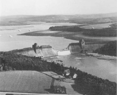
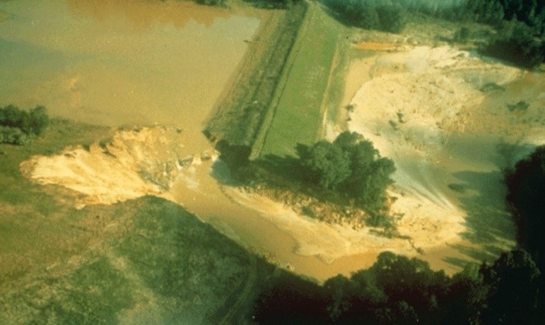
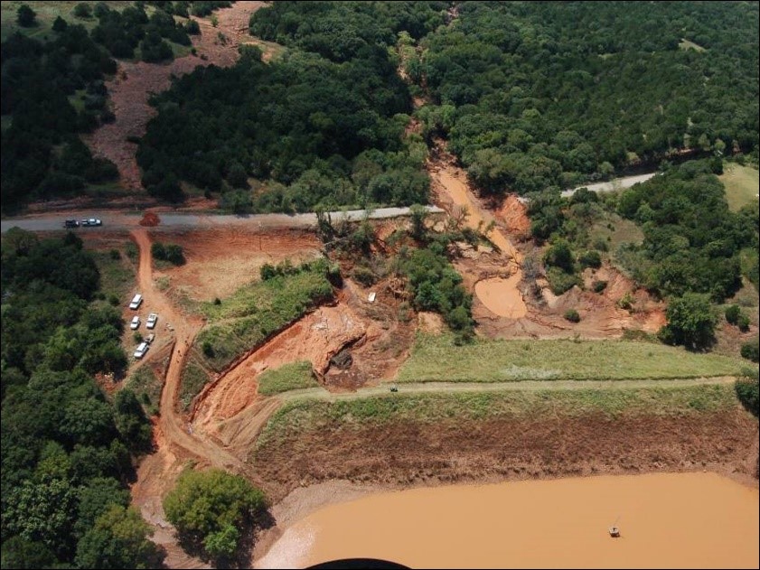
A lesson learned from evaluating the performance history of earth-cut spillways is that many of these spillways have been constructed in erodible material that can result in unsatisfactory performance and breaching of the spillway. An example of this is Sugar Creek Site L-44 Dam. Sugar Creek L-44 Dam is a 64-foot high earthen embankment dam in Oklahoma with a drainage area of 2.7 square miles and a 40-foot-wide auxiliary spillway. In 2007, significant rainfall activated the auxiliary spillway and eroded the downstream slope of the dam embankment. It was concluded that the flow exceeded the allowable stress of the vegetation protection and eroded the earth auxiliary spillway and training dike. A tailwater effect was also created by a county road downstream of the dam which created circular flow regimes between the right training dike and dam that lead to erosion of both, and near breaching of the dam embankment (Anderson and Bass).
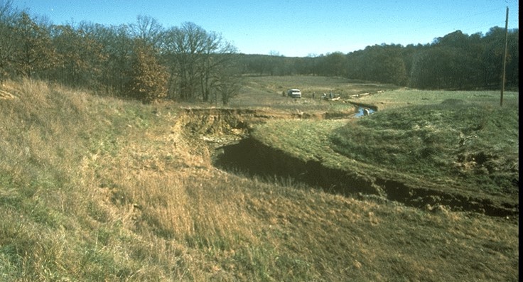
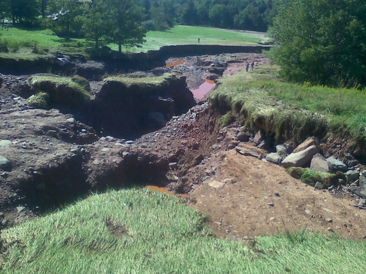
Another important lesson learned is that earth-cut spillways should be maintained as originally designed and constructed. Earth-cut auxiliary spillways should be maintained with uniform and well-vegetated surfaces without any discontinuities such as tire tracks or modifications that would concentrate flow. Poor maintenance of the vegetative cover and post-construction modifications such as road cuts, fences, drainage ditches, woody vegetation, etc. can concentrate the flow and accelerate erosion. An example of this is Black Creek Site 53 Dam located in Mississippi. Black Creek Site 53 Dam consisted of a 50-foot high earth embankment on a 19 square mile watershed. The auxiliary spillway was 100-feet wide with 3H:1V side slopes. The spillway consisted of multiple soil strata armored with vegetation that was maintained in good condition. There were no major discontinuities within the spillway; however, a farm road was added after the spillway was constructed that crossed the spillway exit channel perpendicular to the flow. This road created a steep cut across the spillway exit channel (Temple, 1989). In May of 1983, two significant storm events occurred within one week of each other causing the spillway to activate and eventually breach. The final breach through the spillway was approximately 40 feet deep, 160 feet wide, and over 500 feet long. The breach effectively drained the flood control pool. It was estimated that 187,000 cubic yards of spillway material was eroded from the spillway (Schweiger et al, 2008).
Thanks to recent research by the ARS and NRCS, rigorous spillway integrity analyses can now be performed. A useful tool for evaluating the integrity of earth-cut spillways is the NRCS SITES model. The SITES model includes features to calculate the three erosion phases in time steps over the passage of the design hydrograph through the spillway based on user inputs of spillway dimensions, vegetal cover conditions, and a subsurface profile of the soil and/or rock layers along with their physical properties. Headcut formation and development is a three-dimensional problem which SITES solves using a simplified profile through the spillway that is input by the user. Because no earth-cut spillway is excavated in perfectly uniform subsurface materials across the width of the spillway, the most erodible profile within the spillway needs to be evaluated.
References:
(5) Temple, D., Wibowo, J., & Neilsen, M. (2003). Erosion of earth spillways. United States Society on Dams.
This lesson learned was peer-reviewed by Paul G. Schweiger, P.E., CFM (GFT).


Hawkins Dam (Washington, 2014)

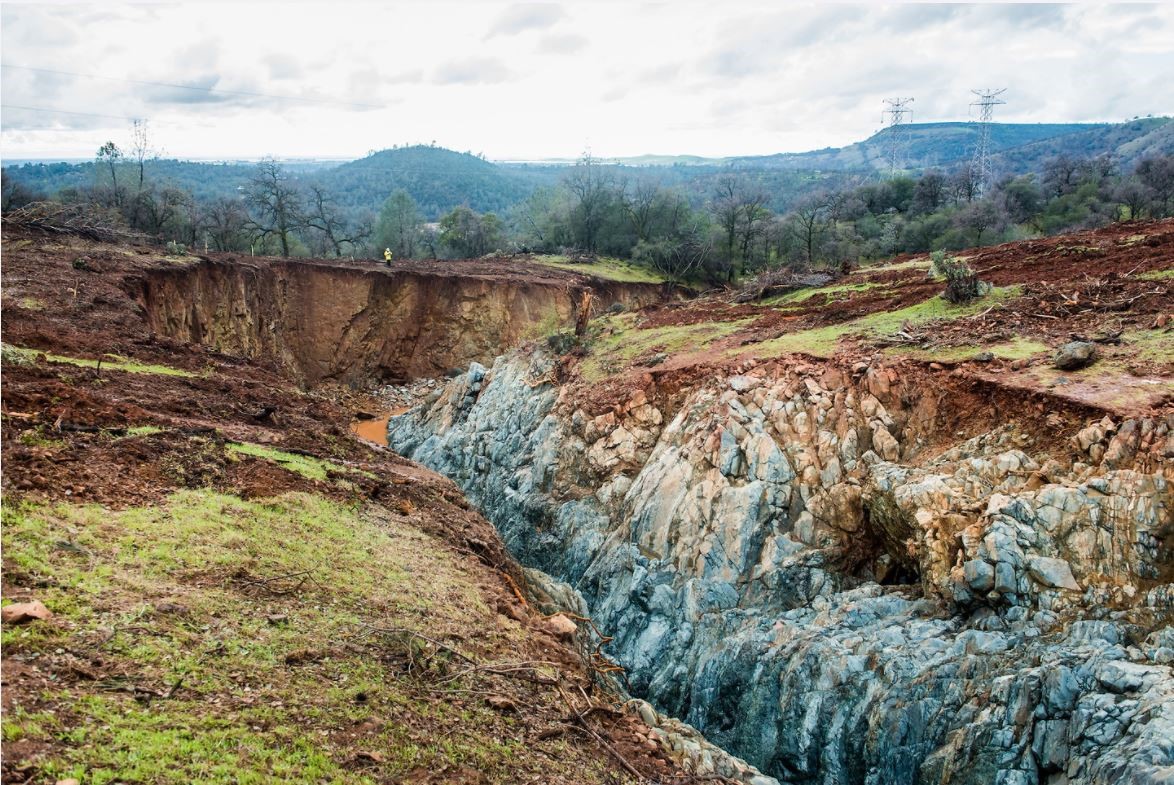
Oroville Dam (California, 2017)

Silver Lake Dam (Michigan, 2003)

Sugar Creek Watershed Dam No. L-44 (Oklahoma, 2007)
Additional Case Studies (Not Yet Developed)
- Black Creek Site 53 Dam (Mississippi, 1983)
- Misteguay Site 4 (Michigan, 1985)
- Buck and Doe Run Site 33 (Missouri, 1986)
- Twin Caney Site 17-3 (Kansas, 1986)
- LaMoure Dam (North Dakota, 2009)
- Clausen Springs Dam (North Dakota, 2009)

Earth Dams and Reservoirs (TR-60)

Selecting and Accommodating Inflow Design Floods for Dams

Technical Manual for Dam Owners: Impacts of Plants on Earthen Dams

A Dam Incident at Sugar Creek L44

A Look at Earth Spillway Design And Evaluation After More Than 50 Years Of Experience

Do Yesterday’s Earth-Cut Spillway Designs Meet Today’s Standards?

Dominant Factors in Vegetated Earth Spillway Failures

Headcut Advance Prediction for Earth Spillways

Headcut Development in Vegetated Earth Spillways

How Many Times did 2,100 Watershed Dams in Oklahoma Experience Auxiliary Spillway Flows in 67 Years?

National Engineering Handbook Part 628 Chapter 50