Overview
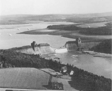
Kingsley Dam is located on the North Platte River in western Nebraska. At 163 feet (50 m) tall and over three miles long, it is the largest dam in Nebraska. On May 1st and 2nd, 1972, a 30-hour windstorm battered and eroded the upstream face of the dam. After breaking through the upstream wave protection, waves removed large portions of the upstream shell, eventually leading to the collapse of more than 400 feet (120 m) of the parapet wall along the crest of the dam. Fearing the dam would fail, residents in the downstream town of Keystone evacuated their homes and headed for higher ground. Crews were immediately summoned to lower the reservoir and begin emergency repairs. Though the winds eventually subsided, and the dam ultimately did not fail, the incident highlights the significant damage a prolonged windstorm can inflict on an earthen dam.
Background
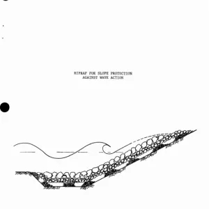
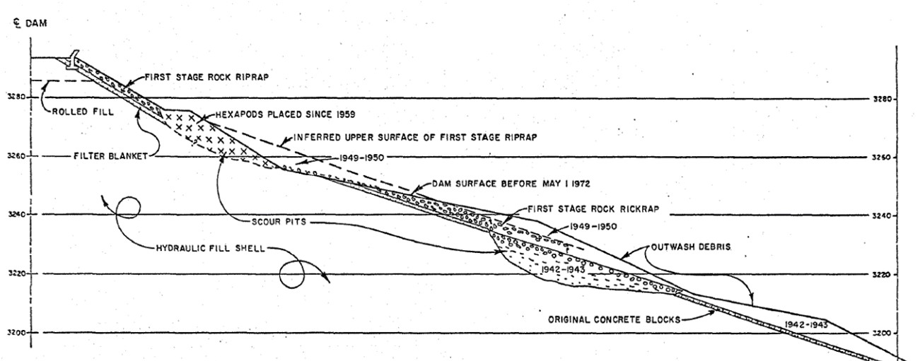
Kingsley Dam, shown in Figure 1, is a zoned hydraulic fill embankment with sand/gravel outer shells and a silt/clay core. It was the second largest hydraulic fill dam in the world at the time of construction from 1936 to 1941. In 1972, the upstream face generally had a slope of 3 horizontal to 1 vertical (3H:1V), transitioning to 2H:1V near the top of the slope, and was covered with rock riprap and concrete hexapods for erosion protection (see Figure 2). There was also a 3-foot (0.9 m) high concrete parapet wall along the upstream edge of the crest of the dam. [5]

On the evening of April 30, 1972, the reservoir behind the dam was slowly rising as it stored water in advance of the upcoming irrigation season. The reservoir was 23.6 feet (7.2 m) below the top of the dam (excluding the parapet wall), and 2.6 feet (0.8 m) below full storage capacity. The total water volume behind the dam stood at approximately 1.8 million acre-feet (2.2 km3). [5]
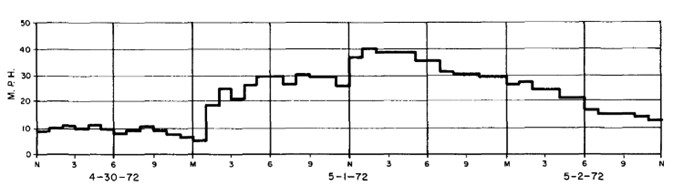
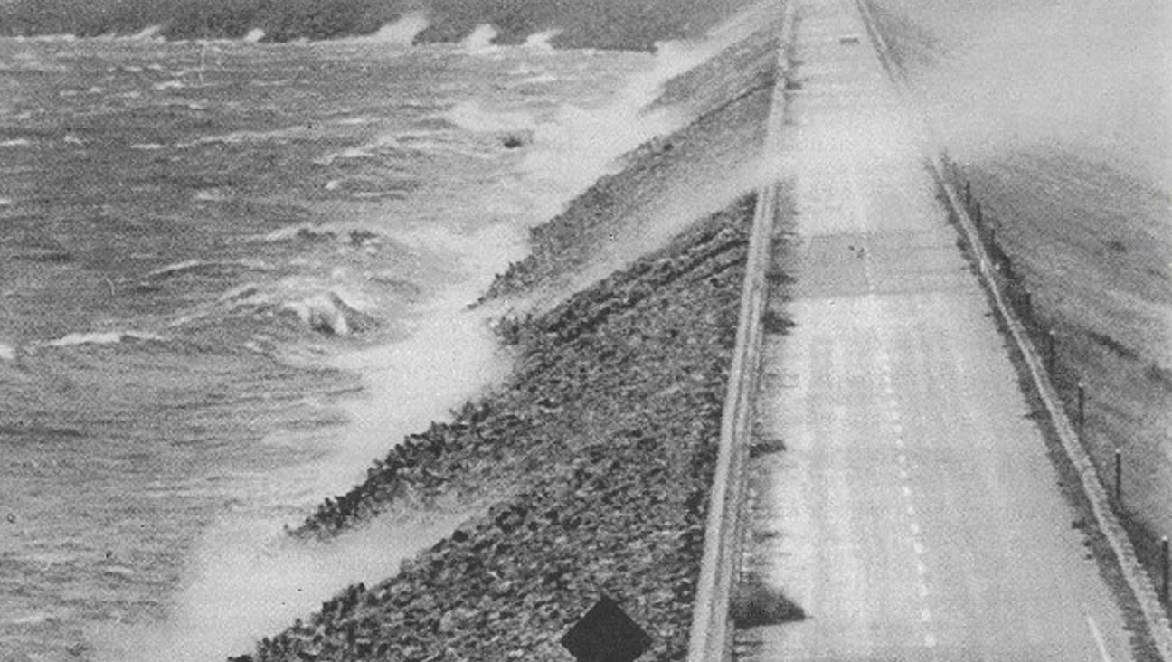
Starting just after midnight, winds picked up across the lake, and by about five o’clock in the morning of May 1, there were sustained winds of 30 mph (50 km/hr) blowing from the west down the 22-mile (35 km) fetch of the reservoir. The winds remained at 30 mph (50 km/hr) throughout the rest of the morning, and then around noon the sustained winds increased to 40 mph (60 km/hr) (see Figure 3), with gusts to 65 mph (100 km/hr), creating waves up to 8 feet (2.4 m) high [2] [4]. As shown in Figure 4, the high winds and crashing waves sent visibly impressive sprays of water over the crest of the dam [6]. While Lake McConaughy and Kingsley Dam had experienced winds of similar or higher magnitude in the past, this storm was unique due to the simultaneous combination of the wind direction, the sustained duration, and the relatively high reservoir level [5].
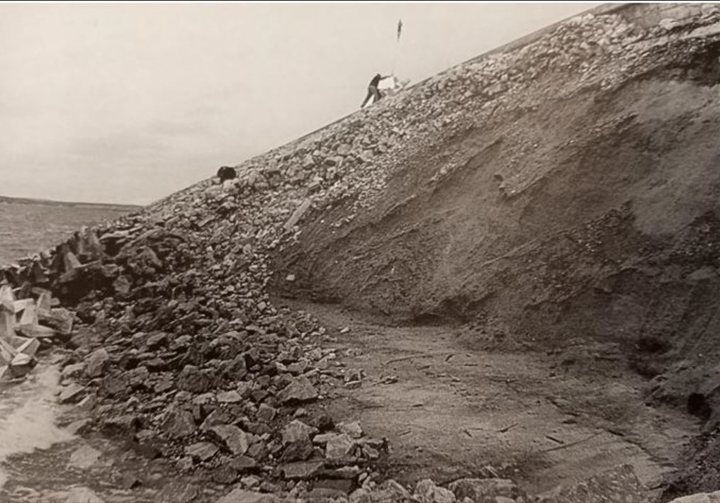
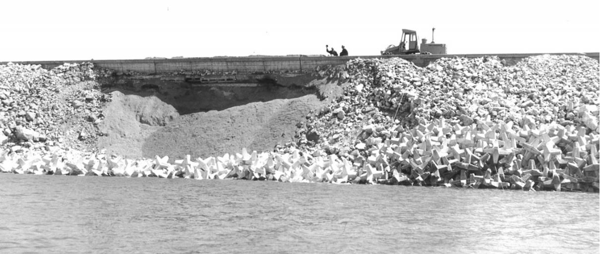
At around five o’clock in the afternoon, it was noticed that the rock riprap slope protection was beginning to slough [3]. Wind speeds started to diminish going into the evening but were still about 30 to 40 mph (50 to 60 km/hr), and the large waves and riprap sloughing continued. Several large holes began to develop where the slope protection had failed, and erosion now began to progress into the upstream sandy shell of the dam. At three locations, the erosion and subsequent sloughing progressed back so far as to undercut the parapet wall running along the upstream edge of the crest of the dam [4].
Witnessing the breaks in the parapet wall, onlookers were astonished and began spreading news about what was happening at the dam. Upon hearing the news and fearing the possibility of a dam failure, most of the residents of the small village of Keystone, located in the river valley 5 miles (8 km) downstream from the dam, left their homes and headed for higher ground [4].
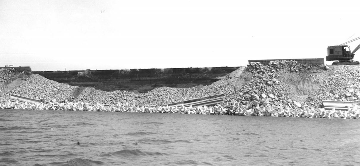
As soon as the riprap damage started to occur, the dam owner began to assemble equipment and personnel to conduct emergency repairs to prevent a possible breach. Soon, there was a continuous caravan of 28 dump trucks transporting materials from emergency stockpiles the dam owner had located near the dam [6]. Concrete “hexapods” were assembled to form barriers across the larger breaks in the upstream slope protection, and rock and gravel were dumped behind these barriers to further shore up the dam. Outflow from the dam was increased from 500 cfs (14 m3/s) to 1,500 cfs (42 m3/s) to begin lowering the reservoir. Although significantly higher release rates were possible, outflows were kept below levels that would cause severe downstream flooding. The wind finally dropped below 25 mph and the waves began to subside at around two o’clock in the morning on May 2, 1972 [3] [4].
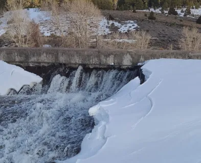
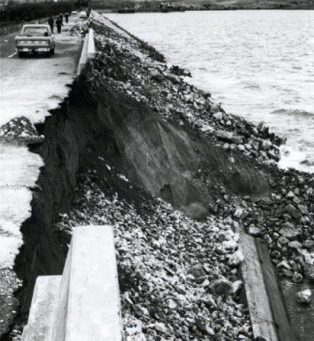
The wind-driven waves resulted in damage at multiple locations along almost the entire length of the dam. The most severe damage extended along a 3/4-mile stretch of the dam where there were twenty eroded pockets, see Figure 5, ranging in width from 20 feet (6 m) to 700 feet (200 m). In three locations, the sloughing reached into the crest of the dam as shown in Figures 6 through 8 [4] [6]. Over 400 feet (120 m) of the concrete parapet wall fell into the eroded pockets, and up to 6 feet (1.8 m) of the 28-foot-wide (8.5 m) asphalt highway surfacing was either lost or undermined. [1] [2]

Within days of the incident, a board of consultants was assembled to investigate. The board of consultants found that Kingsley Dam had suffered wave damage on numerous occasions between its completion in 1941 and the 1972 event. On at least four occasions, windstorms caused major damage to the dam. After each of these events, significant repairs and/or modifications were made to the slope protection. [4]
Ultimately, the board concluded, “the May 1, 1972 damage to the slope protection of Kingsley Dam was initiated with the removal of the cohesionless fine sand of the embankment shell and/or filter blanket from beneath the rock riprap, by wave action. Depressions developed in the protective surface and ultimately all slope protection was removed by the waves...” The board found that the filter blanket was too thin and inadequate in protecting the underlying fine sand in the dam embankment from erosion. The board also concluded that the previous slope failures over the past 30 years could also be primarily attributed to the movement of the gravel bedding and embankment sand materials through the voids in the overlying concrete blocks, rock riprap, and hexapods. [4]
The board did note that “there was never a danger of failure of the dam because of wave damage during the May 1, 1972 storm. If there had been, the reservoir level could have been quickly lowered a sufficient amount to ensure safety, by releasing a large amount of water.” They did, however, acknowledge that such an action likely would have resulted in severe flooding in the downstream floodplain. [4]
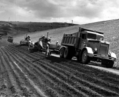
The board of consultants also developed a design for permanent repairs intended to minimize shell and filter particle erosion from beneath the riprap face. These repairs were made to both failed and un-failed areas along the length of the dam. In placing these materials, the slope of much of the upper elevations of the upstream face was reduced from 2H:1V to 3H:1V, continuing the new slope down to the point where it intersected with a lower bench that was formed by deposition of the material that had been washed out from above. [4]
References:
(1) Allen, T. (1972, May 2). Repairs Cut Danger at Kingsley Dam. Omaha World Herald.
(2) Allen, T. (1972, May 3). $500,000 Needed to Fix Eroded Kingsley Dam. Omaha World Herald.
(3) Bishop, R.F. (1972, May 3). Office Memorandum, Kingsley Dam Inspection A-2374. Nebraska Department of Water Resources.
(4) Clevenger, W.A., Phillips, O.O. & Walker, F.C. (1973). Slope Protection of Kingsley Dam.
(6) Richter, R. (2002). Lake McConaughy: A Geographic Portrait. Keith County News.
This case study was peer reviewed by A.Tom MacDougall, P.E. (RJH Consultants, Inc.).


Lessons Learned

Intervention can stop or minimize consequences of a dam failure. Warning signs should not be ignored.
Learn more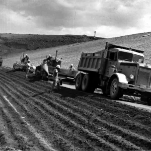
Wind loading can have a significant impact on dam safety.
Learn moreAdditional Lessons Learned (Not Yet Developed)
- Erosion by wave action is a credible threat to dam safety.
- Properly designed riprap/hexapod erosion protection must include a properly graded bedding of sufficient thickness to protect the erodible shell materials.
- Emergency stockpiles and equipment should be readily available in case of an emergency.
- Repeated damage to any critical feature of a dam can be a warning sign that underlying problems should be better understood and addressed.
Design Standards No. 13: Embankment Dams - Chapter 7