Introduction
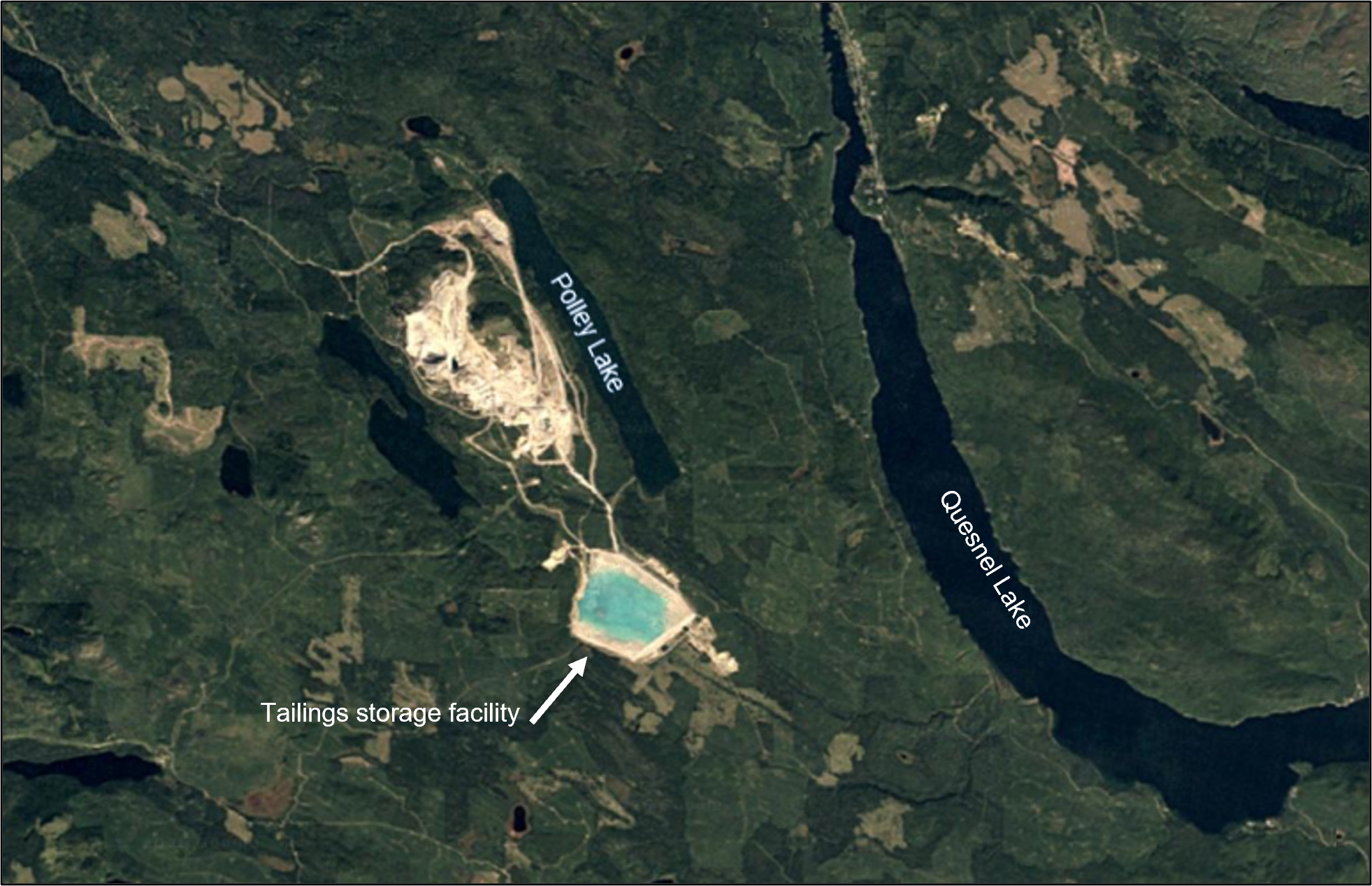
The Mount Polley gold and copper mine is located in British Columbia, Canada and is owned and operated by the Mount Polley Mining Corporation, a subsidiary of Imperial Metals. It began operation in 1997 and was closed and placed on care and maintenance in 2019. It is located near Polley Lake and Quesnel Lake (Figure 1).

Overview
This area of western British Columbia is called the Golden Triangle because of the gold and copper mineralization that has been discovered (Chambers, 2016). The underlying geology of the area has an unusually high concentration of copper rock minerals that formed approximately 180 million years ago. The copper rock minerals (ore) are dug out of open pits and from underground, then crushed, and the copper rock minerals are removed in the mill. The tailings are the crushed rock left over after the copper-rich minerals are removed (Golder Associates, 2016).
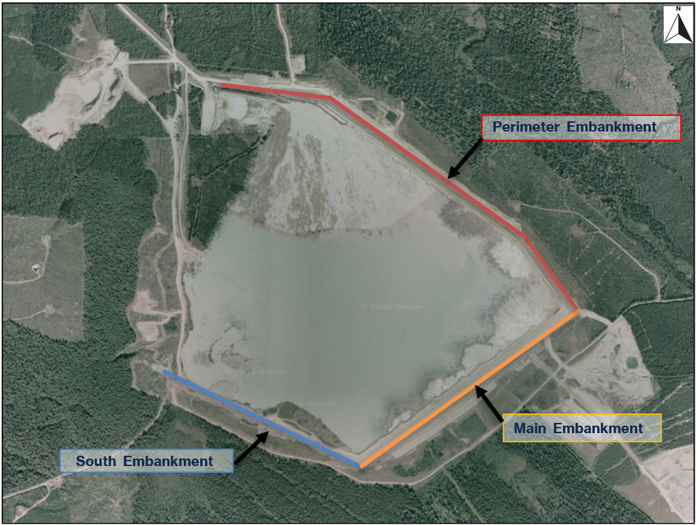
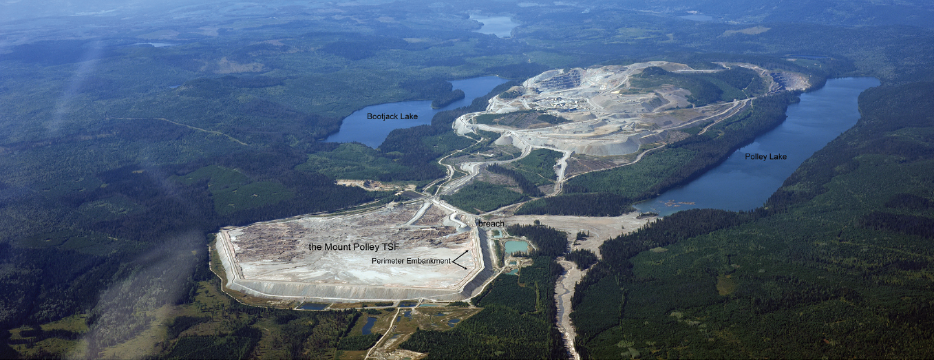
The Mount Polley tailings storage facility (TSF) is comprised of three contiguous embankments (Figure 2). The embankments have an impervious core with a filter zone downstream of the core. The core and filter are supported by a rockfill zone. The breach occurred in the Perimeter Embankment.

Construction of Tailings Storage Facilities
Mine tailings, also referred to as “slimes,” are the chemical-laden waste result of mining and processing minerals. The tailings are typically a mixture of sand, silt, metals, chemicals, and water; they can be solid, liquid, or a slurry of fine particles, and are often toxic and potentially radioactive (Piciullo et al., 2022). Tailings are usually discharged as a slurry to a tailings storage facility via open-ended pipe discharge, or in some cases, by spigotting or cycloning (separation of tailings into finer and coarser fractions using centrifugal force). The solids settle to the bottom of the pond and form tailings beaches that become an important buffer between a pond’s embankment and the water (Marshall, 2018). Impoundments can be operated as one or more isolated compartments, each with its own delivery and decant system (Marshall, 2018).
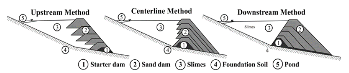
Tailings dams are typically constructed with a starter dike or embankment sized to impound the initial two or three years of tailings plus freeboard for storm storage. The dike is raised over time to retain the rising elevation of tailings deposits. Tailings dams are generally constructed using one of three methods: upstream, downstream, and centerline, which refers to the direction the crest moves in relation to the initial starter dike as the dam is raised (Figure 3). In the upstream method, a starter dike is constructed, then tailings are discharged around its crest to form a beach. The beach then becomes the foundation for a second perimeter dike, and the process continues. In the downstream method, tailings are initially discharged behind a starter dike. The dike embankment is raised by placing fill on the downstream side of the embankment. In the centerline method, a starter dike is constructed, and tailings are discharged from the dike crest to form a beach. The embankment is raised by placing fill on the beach and the downstream slope of the embankment simultaneously. The upstream method is generally the least costly but provides the least stability. Conversely, the downstream method generally provides the most stability but is the most costly (Williams, 2021).

Tailings Dam Failures
The rate of tailings dam failures has been estimated to be as much as two orders of magnitude greater than that of water dams (Blight and Fourie, 2014). Tailings dams built using the upstream method are more prone to failure and more susceptible to static and dynamic liquefaction (Piciullo et al., 2022). The upstream method is considered the least stable (and highest risk) because: 1) there is higher potential for foundation instability, since the walls of upstream tailings dams are raised over a base of unconsolidated mine waste slurry; 2) excess pore water pressures can be generated as the dam is raised, thus further reducing stability; and 3) elevated pore water pressures can increase the risk of static liquefaction, causing a large and abrupt loss of strength and flow failure. Under dynamic loading conditions, such as an earthquake, tailings may also liquefy, lose strength, and fail, as in the case of Barahona Dam No. 4 in Chile in 1928. Since 1915, there have been at least 257 recorded failures of tailings dams, causing approximately 2,650 fatalities and 250 million m3 (203,000 acre-feet) of contaminated tailings released (Piciullo et al., 2022).
Construction of the Mount Polley Tailings Storage Facility
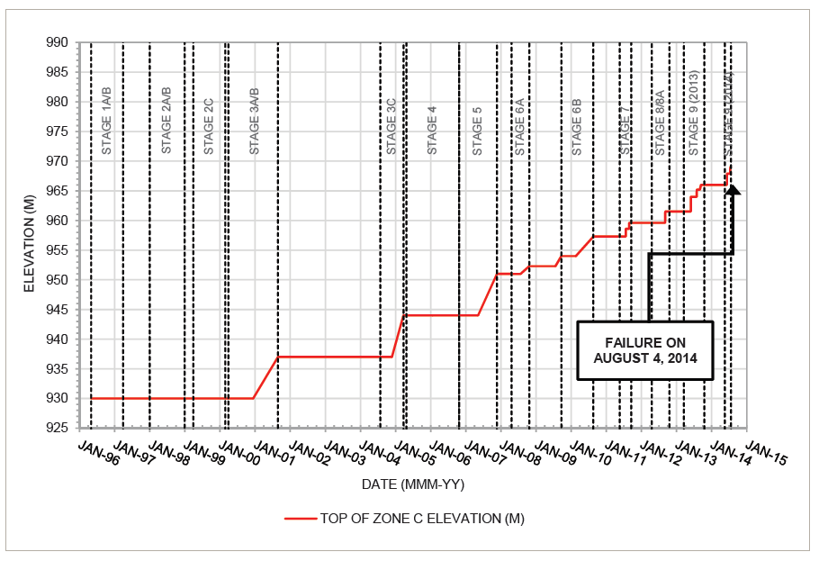
Design of the Mount Polley tailings storage embankments began in 1995; each embankment raise was referred to as a Stage. Construction of the Starter Dam began in 1996. The design of Stage 1 included a small dam a few meters high to close off a depression in the topography west of the Main Embankment. It was designated the Perimeter Embankment and would grow to be a significant embankment contiguous with the Main Embankment. Figure 4 illustrates embankment construction over time.

Construction of Stage 1 was completed in 1997. Embankment raising was to be implemented using a modified centerline method, which meant the dam would rely upon deposited tailings to provide structural support for the core. Fill consisted primarily of glacial till borrow soils with tailings obtained by cycloning placed upstream of the core.
The presence of glaciolacustrine fine sands, silts, and clays was recognized from the outset in the Main Embankment foundation. They were described as “typically dense to very dense and have been heavily overconsolidated by glaciers,” with two samples confirming that they consisted of stiff, overconsolidated materials.
Stage 2 was designed to be the first “modified centerline” raise of the embankments. Construction was completed by 2000. The as-built condition differed from the design in several aspects. Mine waste fill was not added to the downstream slope as intended in the design and a berm along the toe was not constructed. Instead of adhering to a centerline configuration for raising the embankments, Stage 2 utilized the upstream construction method. These deviations from the design were not reconciled with the stability analysis for Stage 2, which was based on the original design configuration from the centerline method. There were also problems with the tailings pipeline system that made it difficult to maintain the required tailings beach and maintain the pool away from the embankments.
During the design of Stage 3, the Observational Method was selected as the basis of design, meaning that each incremental raise going forward was to be continually reevaluated during operations based on measured data from piezometers and inclinometers.
Mine operations were suspended on October 13, 2001, for economic reasons; operations resumed in February 2005, and the design of Stage 4 moved forward. It called for raising the crest using the upstream method and placing rockfill on the downstream slope of the Main Embankment; however, the rockfill buttress was not constructed.
During this time, the Ministry of Energy & Mines (MEM) raised questions about the glaciolacustrine foundation materials and their effect on dam stability. They called attention to softer deposits at a groundwater well downstream from the Perimeter Embankment. In response, the Engineer of Record pointed to test pits and borings as confirming the glaciolacustrine deposit encountered in that groundwater well was a discontinuous unit and would not adversely affect the dam stability. The breach would occur 300 m due west of this location.
The problems with water management and maintaining the required tailings beach persisted, with water directly against the embankment in some areas. As a solution to this problem, the tailings pipe traversed the entire embankment perimeter. In 2006, a mandatory third-party dam safety review (DSR) report was prepared by an outside engineering firm. The DSR noted that lack of tailings placement strategy impeded development of a tailings beach, calling it a deficiency and noting that the dam had not been designed as a water dam.
Construction of Stage 5 was completed in 2007. It incorporated a downstream zone of rockfill that was to be sourced from mine waste, not quarried. Therefore, production and delivery of the rockfill was dependent upon mine production. As a result, the slope of the Zone C rockfill slope was steepened from 2H:1V to 1.4H:1V “temporarily” until rockfill delivery could catch up with construction. However, construction was completed in 2007 without flattening the overly steep slope, and it was put off to future stages of embankment raising. At the time, the Engineer of Record incorrectly concluded that there was sufficient undrained strength in the lacustrine unit for the embankment to remain stable. This conclusion would never be called into question going forward.
Construction of Stage 6 occurred over a period from early 2008 to summer of 2010. The Stage 6 design included placement of 7 m of fill on the crest and a rockfill buttress at the downstream toe of the Main Embankment. However, the rockfill buttress was not constructed as designed again; it was constructed 5 m lower than the design height and to a shorter extent. During this time, following up on the results of the DSR, the MEM requested the results of the Engineer of Record’s direct shear testing. An undrained strength analysis was performed that represented the foundation clay as soft, normally consolidated clays, instead of stiff and highly overconsolidated. The Engineer of Record calculated a factor of safety of 1.1 from their undrained strength analysis and concluded that there was sufficient undrained strength in the lacustrine layer for the embankment to remain stable. A tension crack was observed at the downstream edge of the rockfill zone at Sta 3+400 of the Perimeter Embankment at its eastern end. It was interpreted to be a result of near-surface movement, and a stability analysis was recommended.
Stage 7 was designed and constructed in 2011, raising the embankment height by 2.5 m. Also in 2011, a new Engineer of Record was hired by the mine owner, and a geotechnical site investigation was conducted, the first major foundation exploration since Stage 1. Eleven sonic drillholes were completed and piezometers were installed in each of them. Three new inclinometers were also installed. The primary purpose of the investigation was to evaluate whether the glaciolacustrine foundation soils contained pre-sheared planes of weakness and to analyze residual strengths. No evidence of pre-shearing was found, and no slickenside features were observed. It was determined that residual strengths did not need to be considered and that the 2010 tension crack in the Perimeter Embankment was not attributed to weak soils in the area. They concluded that the glaciolacustrine layer was overconsolidated, which was consistent with previous interpretations, and noted that the foundation conditions under the Perimeter Embankment appeared more favorable than the conditions under the Main Embankment.
Stage 8 was designed and constructed in 2012; initially, it was designed as a raise of 3.5 m, and then it was increased to a raise of 5 m. Flattening of the overly steep slopes from Stage 5 was deferred until the completion of the entire dam. The Engineer of Record used a peak strength interpretation of the glaciolacustrine materials based on the findings of the 2011 geotechnical investigation.
The Stage 9 was designed and construction was started in 2013. The design called for an embankment raise of 6.5 m. The design for Stage 9 used the peak-strength interpretation of the glaciolacustrine foundation soils, resulting in a factor of safety (FOS) of 1.3 in the effective stress analysis for the Main Embankment. The MEM commented that,
“The stability analyses indicate that the FOS for the ‘Main Embankment’ only marginally achieves the short term CDA design criteria of 1.3. ... Previous correspondence from MEM has highlighted the difference in interpretation of the CDA Guidelines. [Engineer of Record] has considered the construction period to be the entire ‘pre-closure’ period while CDA Guidelines, Table 6-2 recommends a minimum FOS of 1.3 ‘before reservoir filling,’ and a FOS of 1.5 at the ‘normal reservoir level.’ MEM requires a commitment from Mount Polley that they are moving toward increasing these FOS for the main embankment as part of subsequent dam raises in an effort to move toward achieving a long term FOS equal to 1.5. It is expected that Mount Polley will continue their transition to centerline construction and provide additional buttressing with time.”
This statement from the MEM indicated a significant change in direction and documented that a factor of safety of 1.5, not 1.3, would become the requirement. Buttressing of the embankments could not be put off any longer. A FOS of 1.58 had been calculated for the Perimeter Embankment based on the assumption it was not affected by the glaciolacustrine foundation soils.
A new Engineer of Record was to be brought on board beginning with the construction of Stage 10, while the previous Engineer of Record was to remain in place through completion of Stage 9 construction. From 2013 to 2014, there was a period of transition and an overlap in responsibilities between the Engineers of Record.
The new Engineer of Record noted the limitations of the embankments and the increasing volume of water it was being used to store. In a June 2013 memo, they documented,
“A continuous beach along the complete upstream length of the dam is the design requirement necessary for dam stability and needs to be achieved moving forward regardless of the final targeted crest elevation. The current water pond surplus does not allow for the development/maintenance of above-water beaches.”
A month later, they noted,
“An above-water tailings beach separating the till core from the water pond constitutes a fundamental design element of the dam. Without a wide above-water beach, the tailings dam is effectively being operated as a water-retaining dam, with the water pond effectively in direct contact with the till core, separated by only a narrow zone of tailings or waste rock.”
In May 2014, as Stage 9 construction was nearing completion, seepage was observed over the dam core. The seepage was monitored and low areas around the embankment perimeter were raised to prevent overtopping of the embankments. The new Engineer of Record was also developing an approach to raising the embankments based on the residual strengths interpretation of the glaciolacustrine soils and establishing new FOS criteria in compliance with MEM’s directive. In July 2014, just a few days before the breach, they finalized a design that would achieve a minimum FOS = 1.5 and would incorporate the possibility of brittle behavior in the glaciolacustine soils. This design included raising the existing buttress on the Main Embankment and adding a new buttress 8 m high on the Perimeter Embankment.
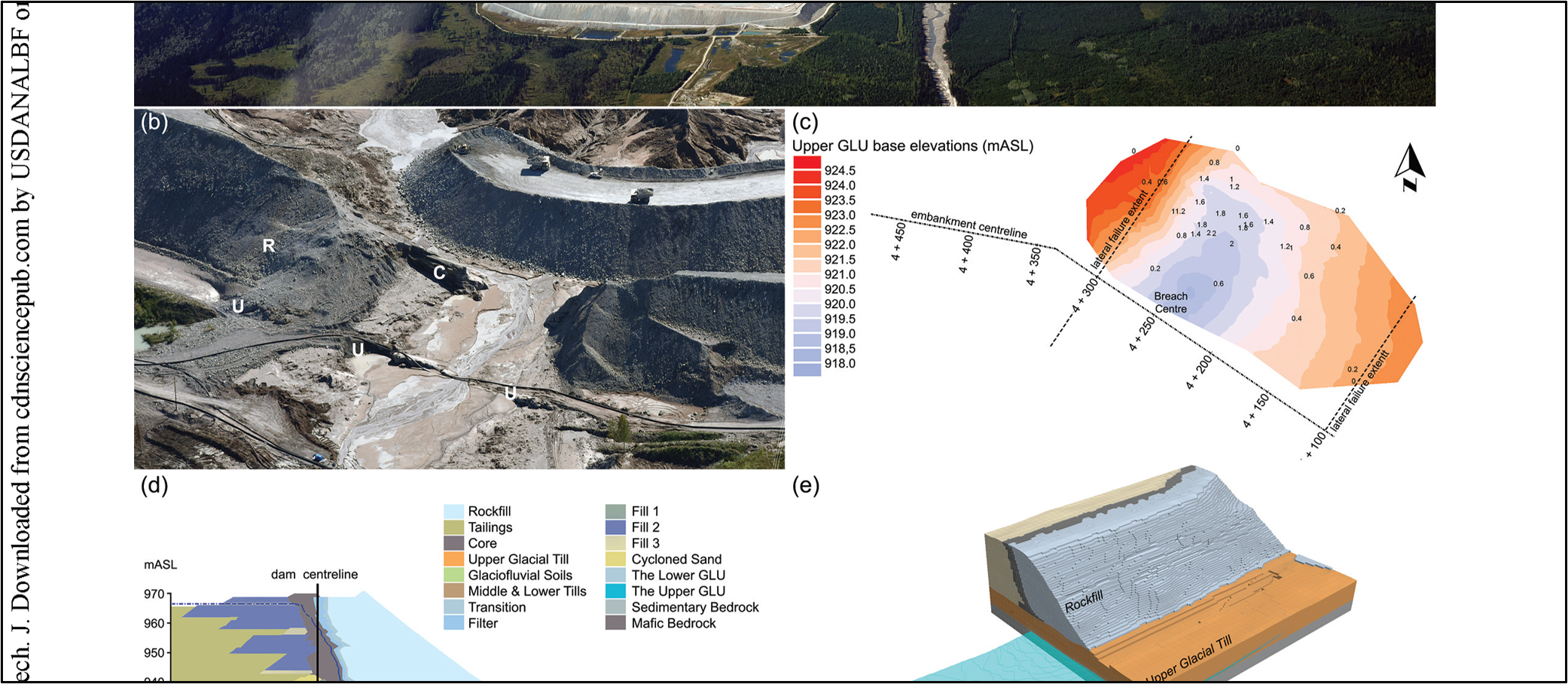
However, the construction of Stage 10 during the summer of 2014 caused a series of inter-related failure mechanics that jointly led to the collapse of the embankment. The addition of the embankment fill triggered a foundation failure in which a soil mass in the Perimeter embankment underwent a rotational-translational movement, which caused the crest to drop and triggered catastrophic release of the stored waste (Zabolotnii et al., 2022). According to the Investigation Report, if the Stage 10 buttress for the Perimeter Embankment had been installed, the dam would have survived.
Failure & Consequences
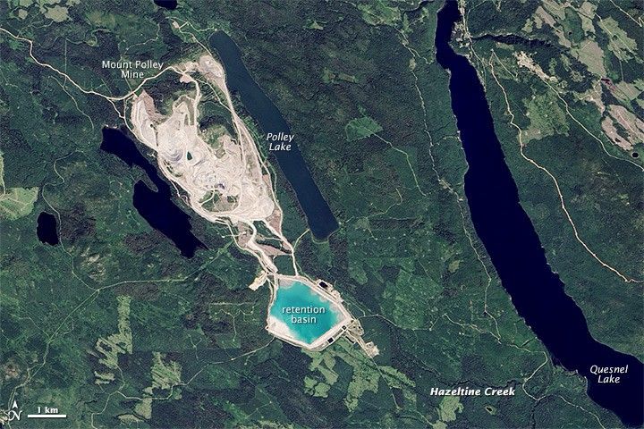
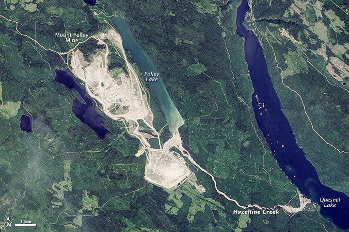
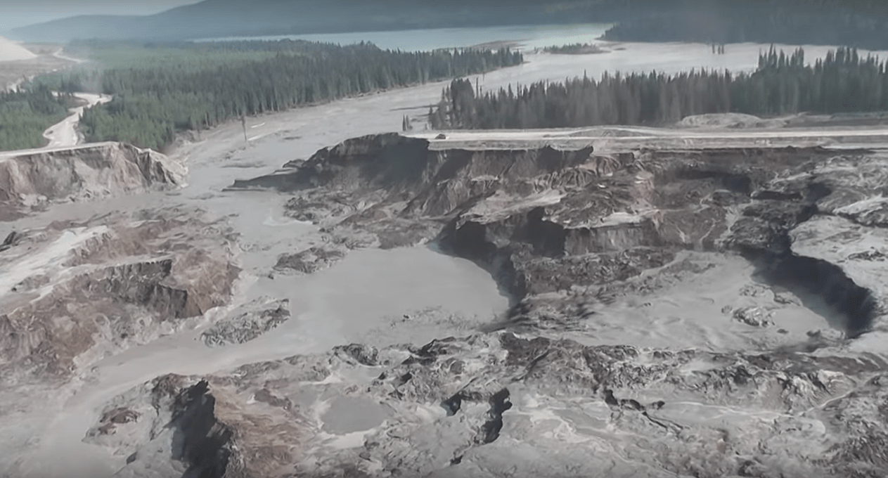
The breach of the Mount Polley TSF occurred early on August 4, 2014, at a core elevation of El. 969.1 m in the Perimeter Embankment. Loss of containment was sudden, with no identified precursors. The pool elevation at the time of failure was 2.3 meters below the crest. 25 million m3 of wastewater, tailings, and construction materials were released downstream into the environment, including Polley Lake, Hazeltine Creek, and Quesnel Lake. It was the largest mine waste spill in Canadian history. When the facility breached, it had a valid permit under the Ministry of Energy and Mines (Permit M-200) with approval to rase the crest by 2.5 meters. Aerial views of the mine pre- and post-failure are shown below.
The mine shut down immediately when the dam failed, and crews were diverted to address the repair of the breach. Two large rock berms were constructed inside the TSF to stabilize the wet tailings inside.


The failure changed the physical environment around Polley Lake, Edney Creek, and Hazeltine Creek. The forest north of the TSF was leveled (Figures 7 and 8). Hazeltine Creek, normally about 1 meter (3 feet) wide, swelled to a width of 150 meters (490 feet) as a result of the spill. In the aftermath of the flood, a layer of brown sediment coated forests and stream valleys affected by the spill. A thick deposit of tailings blocked the flow of water from Polley Lake at its discharge to Hazeltine Creek (referred to as the Polley Plug). Tailings deposits in this area near the breach location were more than 3.5 meters (11.5 ft) thick in some areas. The elevation of Polley Lake was reduced to decrease the pressure on the Plug area and the likelihood of its rupture. The deposited waste was contaminated with arsenic, lead, and other heavy metals. A water-use ban was implemented in Likely, British Columbia; it was lifted August 12, 2014 (Allen and Voiland, 2014).

Investigation & Findings
Three separate investigations were launched following the failure: an independent expert engineering panel was established to determine the root cause of the breach, the Chief Inspector of Mines investigated, and the British Columbia Conservation Officer Service investigated.
Both the expert panel and the Chief Inspector found that the Mount Polley tailings dam failed because the strength and location of a layer of clay underneath the dam was not accounted for in the original design or in subsequent dam raises. The Chief Inspector also found other factors including the slope of the perimeter embankment, inadequate water management, insufficient beaches, and a sub-excavation at the outside toe of the dam that exacerbated the collapse of the dam and the ensuing environmental damage.
The failure of the TSF was caused by deformation of the northern section of the Perimeter Embankment due to foundation failure, which occurred because of inadequate strength of a continuous layer of glaciolacustrine clays. There was an oversimplified understanding of the complex stratigraphy of the glacial deposits. The upper glaciolacustrine layer had been encountered in a groundwater well not far from the breach area; however, only the lower unit was included in the stability analysis of the Perimeter Embankment, and it did not affect calculated factors of safety. The possibility that the upper layer might be present beneath the Perimeter Embankment was not accounted for in geologic site conceptualizations. The glaciolacustrine clays were assumed to be overconsolidated, though there were no attempts to quantify their degree of overconsolidation or stress history. As a result, designers failed to adopt the appropriate undrained strength interpretation for the glaciolacustrine materials in the foundation and failed to recognize that it was susceptible to undrained failure when subject to the stresses associated with the embankment (Hoffman, 2015).
The type and extent of pre-failure site investigations were not sufficient to detect this stratum or to identify its critical nature. The glaciolacustrine layer was found to be preconsolidated prior to embankment construction but became normally consolidated under the loads applied by construction of the Perimeter Embankment, meaning that it had experienced prior consolidation and strengthening under loads in its geological past, but not under the loads associated with the Perimeter Embankment, which created the normally consolidated state. Under these conditions, the layer was compressible, contractive, and susceptible to undrained failure. It was not recognized that the increasing loads imposed by the embankments as they grew in elevation could cause them to reach a normally consolidated state. The embankment slope had been constructed to a height of almost 40 m on an unbuttressed slope of 1.3H:1V, making it marginally stable. As the tailings loading increased over time, the weight on the foundation increased until the strength of the glaciolacustrine layer was exceeded and it could not support the load, abruptly and catastrophically collapsing. The specifics of the failure were triggered by the construction of the downstream rockfill zone at a steep slope of 1.3H:1V. Had the downstream slope in recent years been flattened to 2.0H:1V, as proposed in the original design, failure may have been avoided. The slope was on the way to being flattened to meet its ultimate design criteria at the time of the failure.
Analysis by Zaboltnii (2022) suggests the embankment failed in a progressive manner, with the initiation of localized foundation failure as early as 2011 when the critical strain of the glaciolacustrine layer was exceeded in a limited section under the core, triggering strain-weakening. By the completion of stage 9A in the fall of 2013, the embankment was susceptible to collapse due to the accumulation of plastic shear strains in the glaciolacustrine layer. The progressive failure remained contained until the summer of 2014.
In 2024, Imperial Metals Corp, the mine owner, along with its subsidiary Mount Polley Mining Corporation, and the engineering firm Wood Canada Limited, were charged with 15 violations of the Fisheries Act. The indictment alleges the companies' work at the mine near Likely, B.C., "resulted in serious harm to fish that are part of a commercial, recreational or Aboriginal fishery … namely the death of fish or any permanent alteration to, or destruction of, fish habitat." (Kurjata, 2024). The offences under the Fisheries Act listed in the indictment carry fines between $500,000 and $6 million (CAD) (Kurjata, 2024). As of the writing of this paper in August 2026, the three corporations were attempting to reduce the charges (Labbe, 2026).
After the Failure
Regulatory Changes & Impacts
Immediately following the failure at Mount Polley, the chief inspector of mines ordered inspections and third-party reviews of TSFs at all permitted mines in B.C. The Canadian Mines Act was amended to strengthen regulatory oversight of the mining industry and enforce compliance, including increased financial penalties and imprisonment. In response to the independent panel’s recommendation to strengthen current regulatory operations, the chief inspector of mines ordered mines to confirm whether foundation materials similar to those at Mount Polley exist below any of their dams.
Following the breach, Engineers and Geoscientists BC took actions to improve dam safety in BC, which included producing professional practice guidelines for site characterization for dam foundations in BC, updating existing guidelines to confirm the duties of the “Engineer of Record,” and holding professional development seminars ("Mount polley: disciplinary hearings announced", 2018). The Province also committed to implement a new requirement that all operating mines with TSFs in British Columbia establish Independent Tailings Dam Review Boards ("New penalties strengthen compliance", 2016).
Investigation and Disciplinary Actions Against Three Engineers
After a multi-year investigation by Engineers and Geoscientists British Columbia (EGBC), the regulatory and licensing body for the practice of engineering and geoscience in BC, three engineers were disciplined in relation to their work at the Mount Polley mine.
A Discipline Hearing Panel of the Engineers and Geoscientists BC determined that engineers Stephen Rice and Laura Fidel demonstrated unprofessional conduct in the course of their work at the Mount Polley Mine. They determined that former engineer Mr. Rice failed to properly fulfill the role of review engineer, demonstrated unprofessional conduct by allowing a junior engineer who had little experience with embankment design (Laura Fidel, P.Eng.) to act as Engineer of Record for the project, failed to ensure sufficient observation and monitoring of the tailings dam, failed to document his review work, and failed to ensure an excavation left unfilled at the toe of the embankment was assessed to determine what impact it may have on the stability of the embankment. Rice was fined $25,000, the maximum fine at the time, and agreed to also pay $107,500 in legal costs to Engineers and Geoscientists BC. He resigned his engineering license in January 2018 and is no longer permitted to practice professional engineering in British Columbia. Should he ever re-apply for registration, he would face a two-year suspension and would need to comply with remedial and supervisory measures before he could successfully be relicensed ("Mount polley investigation concludes", 2022; "Mount polley: regulator announces", 2021; The Engineers and Geoscientists Act v. Stephen Rice, 2021).
A separate Discipline Hearing Panel found that Laura Fidel, P.Eng. committed several acts of unprofessional conduct in relation to her engineering work at Mount Polley Mine TSF. The Panel found that Ms. Fidel failed to ensure sufficient observation and monitoring of the tailings dam while acting as Engineer of Record, including by failing to ensure sufficient site visits and failing to monitor seepage flows which could provide evidence of a potentially unsafe condition within the embankments. Ms. Fidel also failed to ensure that an excavation left unfilled at the toe of the embankment was assessed to determine what impact it may have on the stability of the embankment, and demonstrated unprofessional conduct by sealing design drawings for the Stage 9 embankment raise without undertaking sufficient review of the design which was not prepared by her. A number of other allegations against Ms. Fidel were found by the Panel not to be proved and were dismissed. Fidel’s registration as a professional engineer was suspended for two months. She was ordered to complete three education courses relating to tailings management, tailings facility design and operation, and engineering management for mine geowaste facilities (The Engineers and Geoscientists Act v. Stephen Rice, 2021).
A third engineer, Todd Martin, was the senior geotechnical engineer responsible for the geotechnical engineering work at the Mount Polley Mine TSF from March 2011 to December 2012. In his Consent Order for the Discipline Hearing Panel, Martin admitted to some of the allegations that aspects of his engineering work were not consistent with prudent engineering practice, including his failure to recommend drilling from the 2011 embankment crest into soils under the footprint of the TSF perimeter embankment to improve the characterization of embankment foundation soils. Martin also admitted that he failed to make a record of important field observations in 2011, a matter which constituted unprofessional conduct. He was fined $25,000 and agreed to pay $69,000 toward the legal costs of Engineers and Geoscientists BC. Mr. Martin stopped practicing engineering in 2018 and resigned his engineering license in January 2020; he is no longer permitted to practice professional engineering or geoscience in British Columbia. Should he ever re-apply for registration, a Consent Order identifies the steps Mr. Martin will have to take to successfully be licensed (The Engineers and Geoscientists Act v. Todd Martin, 2022).
The full text of the disciplinary results can be found at https://egbc.ca/Discipline-Notices
Finally, these cases were conducted under the legislation in place at the time the engineering work was undertaken (the Engineers and Geoscientists Act), which allowed for a maximum fine of $25,000. That legislation has since been repealed and replaced by the Professional Governance Act, which allows for fines of up to $100,000 for individuals and $250,000 for firms. In addition, EGBC has been granted the authority to regulate engineering and geoscience firms – a new regulatory responsibility that will enhance its ability to protect the public and address standards of conduct and practice at the organizational level ("Mount polley investigation concludes", 2022).
Human Factors Contribution to Failure
Failures are often preceded by interacting physical and human factors that begin years or even decades before the failure (Alvi, 2013). In the case of the failure of the Mount Polley TSF, the underlying site geology was a driving physical factor. However, it is the series of human factors that enabled the catastrophe to unfold as it did.
Construction of the TSF embankments was dependent upon mining production for availability of material for the rockfill buttress; when the mine did not produce the volume of material needed, design changes ensued that were not supported by stability analyses. These pressures from non-safety goals led to changes during construction that allowed overly steep slopes without supporting stability analysis and deferral of critical stability buttressing.
An adequate water balance and water management strategy was lacking throughout the course of the structure’s life. Management of the TSF seemed to be on a year-to-year basis, without a long-term strategy in place to manage water. As a result, operations were reactive rather than proactive in anticipating long-term storage and management needs. This ad-hoc approach to dam raising frequently resulted in an as-built condition that differed significantly from design.
The persistent absence of a well-developed beach meant the dam was operated as a water storage dam, not a tailings storage dam, yet it was not designed or constructed to the more stringent criteria required for water storage dams. The failure to adequately identify and characterize the glaciolacustrine layer under the Perimeter Embankment was a result of overconfidence by the Engineers of Record in their knowledge of site geology, and their ignorance of the complexity of the glacial geology.
Conclusions
The failure of the Mount Polley TSF was caused by a confluence of physical and human factors over a period of years. While the Perimeter Embankment breached suddenly, the failure was likely progressive, initiating years before the breach, and originating in a weak glaciolacustrine layer in the foundation. The design did not adequately account for the complexity of the underlying geology, particularly the weak clay layer. A thin shear zone developed, where the clay lost strength. As additional load was placed on the foundation during the construction of Stage 10, the strain-weakening in this layer increased, triggering rapid expansion of the failure zone, loss of confinement and deformation. The overly steep embankment slope, deferred buttressing, and inadequate water management were contributing factors in the failure.
References:
(10) NASA. (2014). Dam Breach at Mount Polley Mine in British Columbia.
(11) Cariboo Regional District. (n.d.) Home [YouTube channel]. YouTube. Retrieved October 1, 2026.
(17) The Engineers and Geoscientists Act v. Stephen Rice. (2021).
(18) Engineers and Geoscientists BC. (2022). Mount Polley Investigation Concludes; Three Engineers Disciplined.
(19) The Engineers and Geoscientists Act v. Todd Martin. (2022).
(20) Alvi, I. (2013). Human Factors in Dam Failures [Conference presentation]. 2013 ASDSO Annual Conference. Association of State Dam Safety Officials.
This case study summary was peer-reviewed by John W. France, P.E., BC.GE (JWF Consulting LLC) and Bill Johnstone, Ph.D., P.E. (Spatial Vision Consulting Ltd).


Lessons Learned
Dam incidents and failures can fundamentally be attributed to human factors.
Learn moreAdditional Lessons Learned (Not Yet Developed)
- Tailings dams constructed using the “upstream method” have been found to be more susceptible to failure.
- Tailings dams are always under construction until their closure. This requires ongoing evaluation to adapt and respond to changing conditions.