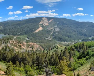
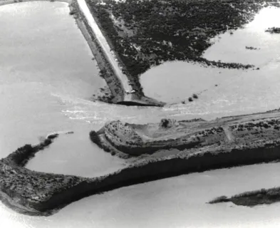
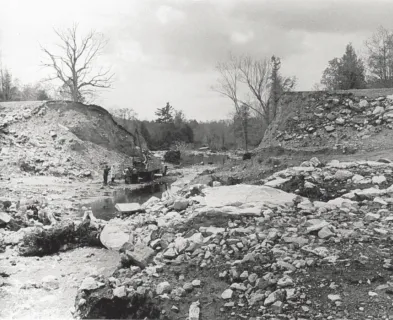
On August 13, 1935, during an intense rainstorm, the Sella Zerbino secondary dam near Molare, Italy failed catastrophically, resulting in at least 111 fatalities in the Orba River valley downstream. It is one of the three deadliest dam failures in Italian history (Luino et al. 2014), yet it remains little known, even in Italy, where it has been called the “forgotten Vajont” (Bonaria 2013). In 1938, a court attributed the failure to an exceptional and unforeseeable storm. However, recent studies have strongly challenged that conclusion.
Project Description
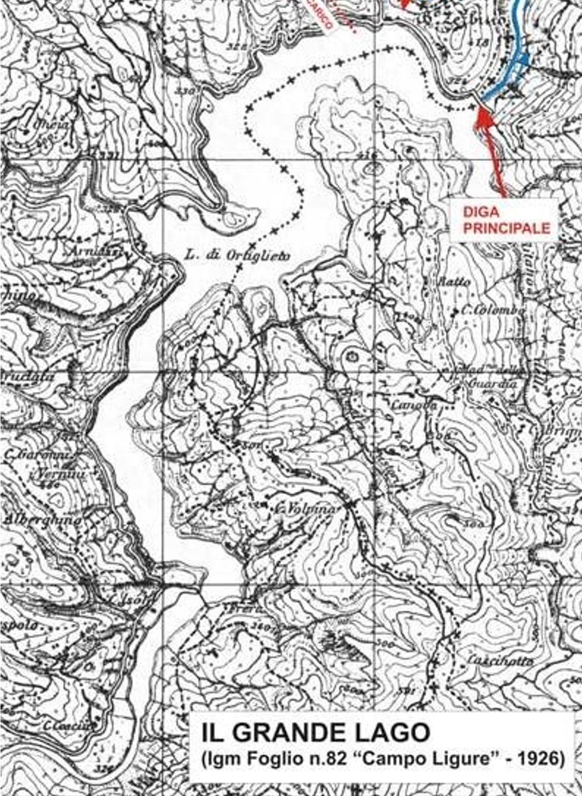
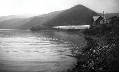
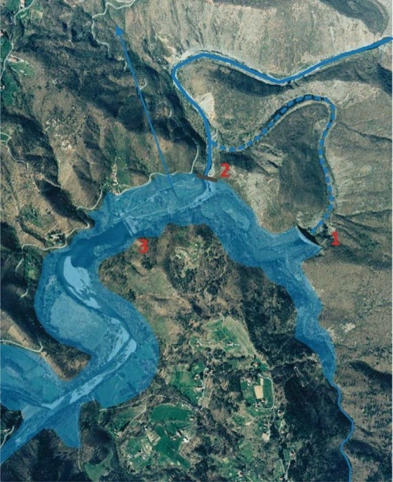
The Ortiglieto Reservoir was created on the Orba River about 3 to 4 miles (5 to 6 km) upstream of Molare and roughly 20 miles (32 km) northwest of Genoa (Figure 1). At the site, the river looped around a rocky hill, Bric Zerbino, which required two dams (Figure 2): the main dam across the river gorge on one side of the hill, and the secondary dam across a low saddle in the ridge, Sella Zerbino, on the other side. At the normal maximum pool level of El. 1,056 feet (322 m), the reservoir had a storage capacity of about 14,600 acre-feet (18 million m³) and a drainage area of about 54 square miles (140 km²) (Jansen 1983; Bonaria and Tosatti 2013; Petaccia and Natale 2013). A headrace pressure tunnel 8,930 feet (2,722 m) long and 9.8 feet (3 m) in diameter, with its intake at the reservoir a short distance upstream of the secondary dam, conveyed water to a powerhouse about 2 miles (3 km) downstream (Bonaria and Tosatti 2011), which had an installed capacity of about 18,000 kW (Petaccia and Natale 2020).
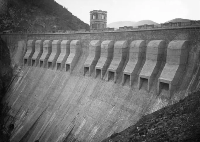
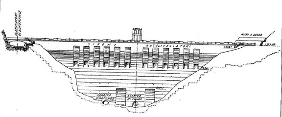
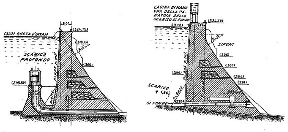
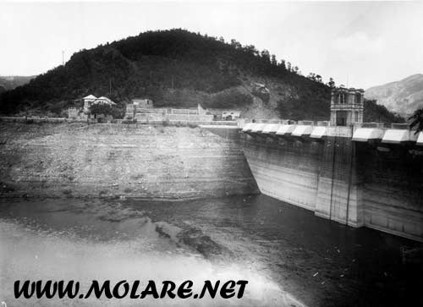
The Bric Zerbino main dam was a curved gravity dam of cyclopean concrete about 154 feet (47 m) high (Bonaria and Tosatti 2013; Abbate and Frigerio 2025), with a radius of about 656 feet (200 m), a crest about 20 feet (6 m) wide at about El. 1,065 feet (324.7 m), and a downstream face slope of about 0.8H:1V (Figures 3 to 5) (Jansen 1983; Abbate and Frigerio 2025). All of the spillways and outlet works for the reservoir were located at the main dam: twelve self-priming Heyn siphon spillways in the crest with a combined capacity of 17,700 feet3/second (cfs) (500 m³/s), a side spillway on the right abutment with a capacity of about 5,300 to 5,700 cfs (150 to 160 m³/s), a mid-level outlet controlled by a “bell valve” with a capacity of about 5,300 cfs (150 m³/s), and a bottom outlet with a capacity of about 1,900 cfs (55 m³/s). The total nominal discharge capacity was about 30,000 cfs (850 to 865 m³/s), or about 31,000 cfs (880 m³/s) including the powerhouse flow (Jansen 1983; Bonaria and Tosatti 2011; Petaccia et al. 2016).
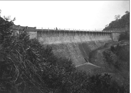
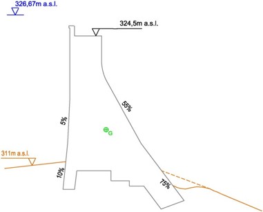
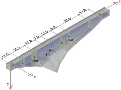
The Sella Zerbino secondary dam was a straight concrete gravity dam about 46 to 48 feet (14 to 14.5 m) high and 360 feet (110 m) long, with its crest at El. 1,064.7 feet (324.5 m), essentially level with the crest of the main dam (Figures 6 to 10). The dam was about 11 feet (3.3 to 3.5 m) wide at the top, with a nearly vertical upstream face, a downstream face slope of about 0.55H:1V to 0.75H:1V (relatively steep for a gravity dam, resulting in a relatively thin section), and a concrete toe block at the maximum section. It was built in four monoliths separated by contraction joints (Jansen 1983; Bonaria and Tosatti 2011; Petaccia et al. 2016; Bonaria, molare.net). The secondary dam had no spillway, outlet, or erosion protection at its toe, since like most saddle dams it was designed as a non-overflow structure, relying on the outlet works at the main dam (Jansen 1983).
Accounts of the internal construction of the secondary dam conflict: Jansen (1983) reports an inspection gallery, drains, a cutoff, and grout holes at the heel, Petaccia and Natale (2020) state that there were no drainage wells or grout curtain, whereas archival research by Bonaria (molare.net) appears to indicate the atypical configuration of there being two concrete walls with salvaged fill between them.
Geologic Setting
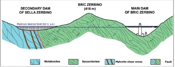
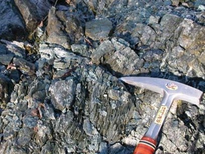
The dams were founded on the Voltri Group, a complex of metamorphosed oceanic rocks (serpentinites, metabasites, and related rocks), which is intensely deformed and cut by numerous faults, with rock quality varying greatly over short distances (Bonaria and Tosatti 2011, 2013). The main dam was founded on relatively compact serpentinite (Petaccia and Natale 2020). By contrast, the Sella Zerbino saddle coincides with a fault zone at the contact between serpentinites and metabasites (Figure 11) (Bonaria and Tosatti 2011, 2013; Petaccia and Natale 2020). The rock there is intensely fractured and contains bands of mylonite, a finely foliated fault rock, which becomes “soapy” when wet, dipping about 55 to 60 degrees (Figure 12) (Bonaria and Tosatti 2011). In fact, the saddle exists because the fault zone eroded more readily than the surrounding rock (Bonaria, molare.net).

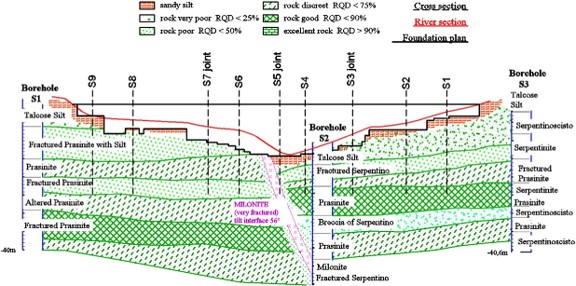
No subsurface investigation of the saddle was performed for the design (Petaccia et al. 2016). Later investigations for a 1980 restoration study found weathered silt and highly fractured serpentinite near the surface, mylonite beneath the riverbed, and compact rock only below a depth of about 65 feet (20 m), and the rock permeabilities adopted in a later seepage model were roughly 30 to 140 feet per day (0.0001 to 0.0005 m/s), values typical of clean sand and quite high for a dam foundation (Figure 13) (Petaccia et al. 2016).
Project History
Planning of the project began in the 1890s under engineer Luigi Zunini, later rector of the Milan Polytechnic (Bonaria 2013). His early designs proposed a smaller reservoir of about 6,500 acre-feet (8 million m³) behind a main dam about 108 feet (33 m) high, with the Sella Zerbino saddle closed not by a full dam but by a low gated overflow sill about 256 feet (78 m) long, serving as the spillway for the reservoir with a capacity of about 14,100 cfs (400 m³/s) (Petaccia et al. 2016; Bonaria, molare.net). The only geologic document attached to the design, through the final design of 1926, was a report of a few pages by Professor Francesco Salmoiraghi, dated 1898 (Bonaria and Tosatti 2013) or 1899 (Bonaria and Tosatti 2011), which was not based on any borings or sampling. The report described a complex of varied rock types in strata “fractured by joints” and noted erodible rock “in the saddles,” yet it concluded that “in any part of this area it is possible to build a dam in full safety conditions” (Bonaria and Tosatti 2011, 2013; Bonaria, molare.net).
In 1916, the Officine Elettriche Genovesi (OEG), an affiliate of the Edison group, the largest electric utility in Italy, gained the concession to develop the site for hydroelectricity (Bonaria and Tosatti 2013). That same year, engineer Vittorio Gianfranceschi redesigned the project to enlarge the reservoir and multiply the output of the hydroelectric plant, chiefly by raising the main dam about 43 to 46 feet (13 to 14 m) to its final height, without an increase in discharge capacity, and construction followed after World War I (Bonaria and Tosatti 2011; Petaccia and Natale 2020; Bonaria, molare.net). Raising the reservoir put the low point of the saddle, at about El. 1,017 feet (310 m), well below the maximum water level, and it was this change that necessitated a dam at the saddle. The reasons given for abandoning the saddle spillway included the poor resistance of the saddle rock to erosion. In effect, the designers judged the rock too erodible to accept overflow and then founded a dam on it (Bonaria and Tosatti 2011; Bonaria, molare.net). In 1921, OEG proposed a non-overflow buttress dam for the saddle, explicitly excluding a spillway because of the poor foundation rock, but the Ministry of Public Works rejected the proposal, and a gravity design was submitted in May 1924 (Petaccia et al. 2016). Yet the 1925 description of the project by OEG stated that the saddle was “composed of solid rock, reached in all parts by the foundation” (Bonaria and Tosatti 2011). The secondary dam was designed and built hastily. Its concrete pours were cast between circa 1922 and 1924 (Bonaria, molare.net), so construction was evidently well underway before the gravity design was submitted, and the final design was not presented to the regional Civil Engineers Board until 1926, after the plant had entered service (Bonaria and Tosatti 2013; Petaccia et al. 2016; Bonaria, molare.net).
The project did not comply with the regulations of the time. A 1921 rule (Ministerial Decree No. 1309 of April 2, 1921) required uplift to be considered in the stability analysis of dams, yet the secondary dam was designed without factoring in uplift (Petaccia et al. 2016). After the Gleno Dam failed in December 1923, resulting in at least 356 fatalities (Luino et al. 2014), a Royal Decree at the end of 1925 (No. 2540) required detailed geologic investigation of dam sites, and a 1931 decree allowed officials to order a reservoir emptied if serious defects could not be remedied (Petaccia et al. 2016; Petaccia and Natale 2020). The 1925 decree came after the design of the secondary dam had progressed, but the final design, submitted in 1926, still had only the 1898 Salmoiraghi geology report attached (Bonaria and Tosatti 2013). Petaccia et al. (2016) concluded that the regulations in force in 1935 would have averted the disaster if they had been enforced.
The hydroelectric plant entered service in January 1925 (or August 1925 according to Petaccia and Natale 2020), with the reservoir filled partly without authorization (Bonaria 2013; Bonaria, molare.net), since the Gleno Commission had approved filling only to El. 1,041 feet (317.40 m), or about 10,900 acre-feet (13.5 million m³) (Bonaria and Tosatti 2013). In hindsight, there were at least seven warning signs related to the secondary dam and the discharge capacity of the reservoir:
- The geologic report itself noted varied, jointed rock and erodible rock in the saddles.
- Fractured rock and mylonite were exposed on the upstream flank of the saddle, and a geologist who examined the site after the failure wrote that they “should not have been difficult” to identify (Airoldi 1935, quoted in Bonaria and Tosatti 2013).
- The designers rejected the saddle as a spillway, and later excluded a spillway from the secondary dam, specifically because of the poor quality and erodibility of the rock (Bonaria and Tosatti 2011; Petaccia et al. 2016).
- The headrace tunnel ran largely through crushed, highly fractured rock, including water-rich mylonite bands near the saddle, which required an unplanned reinforced concrete lining (Cannonero 1935, quoted in Bonaria, molare.net; Bonaria and Tosatti 2013).
- Leakage through the saddle, observed by the Gleno Commission in 1924 (Bonaria and Tosatti 2011), reached up to about 475 gallons per minute (30 L/s) according to Bonaria and Tosatti (2013) and about 950 gallons per minute (60 L/s) according to Petaccia et al. (2016), and grouting failed to stop it.
- Inspections in 1928 and 1929 noted cracks in the secondary dam, while still describing both dams as normal (Bonaria and Tosatti 2013).
- Within two years of commissioning (August 1925 or November 1926, depending on the source), a flood raised the reservoir about 2 feet (0.7 m) above its normal maximum level and threatened to overtop the dams. In response, the side spillway at the main dam was enlarged, raising the nominal discharge capacity to about 30,000 cfs (850 to 865 m³/s) (Bonaria and Tosatti 2013; Bonaria 2013; Petaccia et al. 2016; Petaccia and Natale 2020). Ironically, in November 1934, a storm which raised the reservoir rapidly was “satisfactorily controlled” by the modified spillway (Bonaria and Tosatti 2013), which may have reinforced confidence in a marginal discharge system.
Hydrology and Design Flood
The Orba basin, on the northern slopes of the Ligurian Apennines near the Mediterranean, is in one of the wettest areas of Italy and responds to intense rain within a few hours (Abbate and Frigerio 2025). According to Jansen (1983), calculations by the designers indicated an inflow of 28,200 cfs (800 m³/s) with a return period of only about 20 years. In 1935, engineer Andrea Cannonero noted that the spillways and outlets had been sized for about 550 cfs per square mile (6 m³/s per km²), whereas a nearby dam had been designed for at least 1,830 cfs per square mile (20 m³/s per km²) (Bonaria, molare.net). However, the under-design was not unique to this project, since Petaccia and Natale (2013) found that the 1935 flood was almost three times the envelope of design spillway capacities of 20 dams in the region, built both before and after 1935.
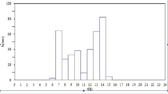
The storm of August 13, 1935 produced about 14.4 inches (366 mm) of rain over the Orba basin in about 8 to 9 hours (Figure 14) (Petaccia and Natale 2013, 2020), and a gauge in an adjacent basin recorded 21.8 inches (554 mm), including 7.2 inches (182 mm) in 2 hours (Luino et al. 2014). The defense at the 1938 trial argued that the storm was unprecedented and unforeseeable (Luino et al. 2014), and it has often been described as a 1,000-year event. However, re-analyses give a wide range of return periods, depending on the gauge and method. Petaccia and Natale (2013) found that the rainfall exceeded a 1,000-year return period at only two gauges and was “exceptional only in a very confined area,” though regional estimates exceeded 10,000 years at one gauge. Petaccia and Natale (2020) estimated return periods of about 150 and 235 years at the two most representative gauges and concluded that “the event was not exceptional,” and Abbate and Frigerio (2025), whose estimates ranged from about 100 to 2,000 years depending on the method, adopted about 200 to 300 years as representative and found broadly comparable floods in the basin in 1977 and 2019. Whatever its exact return period, a storm of this kind was foreseeable in this climate and basin, and the dams had essentially no margin for it. By comparison, a high hazard dam in the U.S. today would generally be required to pass the probable maximum flood or a risk-informed inflow design flood (FEMA 2013).
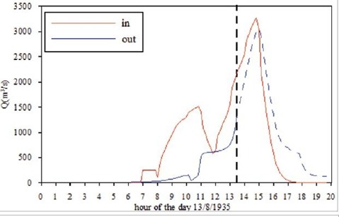
Estimates of the peak inflow to the reservoir range from about 71,000 to 81,000 cfs (2,000 to 2,300 m³/s) (Abbate and Frigerio 2025), similar to the estimate of about 80,500 cfs (2,280 m³/s) made by a Ministry of Public Works commission the day after the failure (Bonaria and Tosatti 2013), to a computed peak of about 116,000 cfs (3,300 m³/s) (Petaccia and Natale 2013), roughly three to four times the discharge capacity (Figure 15). Notably, the secondary dam failed before the inflow peaked. At 1:20 pm, the inflow was about 67,000 cfs (1,900 m³/s) and “was still increasing” (Petaccia and Natale 2013), the heaviest rain fell between 2 and 3 pm (Figure 14), and the inflow peaked around 2:50 to 3:00 pm (Petaccia and Natale 2013; Abbate and Frigerio 2025), more than an hour after the failure. Had the secondary dam not failed, the overtopping would have continued to deepen, and the main dam was never tested at the peak, since the breach drew the reservoir down.
The Failure
After a long drought, the reservoir level was low on the morning of August 13, 1935, and the outlets were closed (Bonaria and Tosatti 2011). The following chronology is based mainly on the testimony of the dam caretaker and the judicial investigation (Bonaria and Tosatti 2011; Il Piccolo 2021; Petaccia and Natale 2020):
- Circa 9:50 to 10:30 am: Staff opened the mid-level outlet, but the bell valve became clogged with mud and debris (Il Piccolo 2021; Bonaria, molare.net). The bottom outlet was apparently not opened, because staff feared vibration of the main dam and its valve chamber was inaccessible during a flood (Petaccia and Natale 2020), though other accounts state that both submerged outlets were opened and “stopped working minutes after they were opened” (Bonaria and Tosatti 2013; Luino et al. 2014), and Jansen (1983) reports that “some difficulty was experienced in hoisting the gate.”
- Circa 10:45 to 11:00 am: According to the testimony of the caretaker, the reservoir reached its normal maximum level (Bonaria and Tosatti 2011), and water began to enter the side spillway (Petaccia et al. 2016). The siphons began to operate at about this time, since in model tests (Petaccia and Fenocchi 2015) they primed only when the reservoir reached its maximum level (Petaccia and Natale 2020). The sources disagree about how quickly the siphons then reached full capacity: Bonaria and Tosatti (2011) state immediately, whereas Abbate and Frigerio (2025) model a delay of about an hour. Petaccia et al. (2016) state that the siphons were operating at full capacity by 9:30 am, but this is inconsistent with the reservoir level of about El. 1,043 feet (318 m) reported at 10:00 am (Bonaria and Tosatti 2013). Total outflow before overtopping was only about 21,000 to 23,000 cfs (600 to 650 m³/s) (Bonaria and Tosatti 2011; Luino et al. 2014).
- 12:30 pm: The reservoir reached El. 1,064.7 feet (324.5 m), and overtopping of both dams began (Bonaria and Tosatti 2011).
- Circa 1:15 to 1:27 pm: The reservoir reached El. 1,071.8 feet (326.67 m), about 7 feet (2.2 m) above the crest of the secondary dam (Bonaria and Tosatti 2011; Petaccia and Natale 2020), though some sources state nearly 10 feet (3 m) (Bonaria and Tosatti 2011; Deroo and Jimenez 2011). Just before the failure, of a total outflow of about 48,000 cfs (1,360 m³/s), it is estimated that about 12,000 cfs (340 m³/s) flowed over the main dam and about 7,400 cfs (210 m³/s) over the secondary dam (Petaccia and Natale 2020).
- Circa 1:15 to 1:30 pm: The secondary dam failed, starting at its west (left) end, and the breach rapidly widened and cut down into the rock saddle (Bonaria and Tosatti 2011; Deroo and Jimenez 2011; Luino et al. 2014; Petaccia et al. 2016). The telephone cable on the crest of the dam broke at 1:27 pm (Petaccia and Natale 2020).
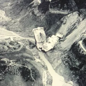
The reservoir level then dropped rapidly, by about 82 feet (25 m), releasing roughly 16,000 to 20,000 acre-feet (20 to 25 million m³) of water and debris (Bonaria and Tosatti 2013; Abbate and Frigerio 2025). Petaccia and Natale (2020) estimated that the dam-break flood peaked at about 321,000 cfs (9,100 m³/s), about three times the flood which would have passed if the dam had held. Contemporary accounts state that the reservoir dropped “within a few minutes” (Bonaria and Tosatti 2013), but even at this peak rate, the release would have taken at least about 40 minutes. The main dam, though overtopped by a similar depth, survived (Figure 16). The Orba has since cut a channel 130 to 150 feet (40 to 45 m) deep through the former saddle, leaving the main dam standing in an abandoned meander (Figure 17) (Bonaria and Tosatti 2011; Deroo and Jimenez 2011).

Failure Mode and Mechanism
All sources agree that overtopping triggered the failure, but they differ on the mechanism, with three explanations having been advanced:
- Erosion at the toe. Jansen (1983) concluded that “there appears to be little doubt that the toe of the small barrier was undermined by the heavy overflows, which precipitated sliding and overturning,” and that the overflow pressures alone would not have broken the dam. This view has been repeated by later authors, including Deroo and Jimenez (2011), Petaccia and Natale (2013), Léger (2023) (whose summary table nonetheless lists the cause as “foundation seepage, sliding, and overturning”), and Abbate and Frigerio (2025). Bonaria and Tosatti (2013) similarly attribute the failure to “the rapid erosion of the jointed rocks which made up the foundation ground.”
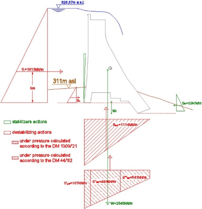
- Overloading with uplift. Petaccia et al. (2016) analyzed nine sections of the secondary dam (Figures 9, 10, and 18) and found that, with uplift through the permeable foundation, the dam was stable with only a small margin at the design maximum level, but that several sections failed in sliding and overturning at the flood level, the most critical being near the west end, consistent with witness accounts. Their estimated scour was only about 4 feet (1.2 m), and they concluded that uplift, which the designers had ignored, was decisive. Petaccia and Natale (2020) likewise attributed the collapse to uplift on the fault beneath the dam, and Luino et al. (2014) also cite uplift (“under pressure”).
- Sliding of the rock saddle. Bonaria (molare.net), citing University of Genoa studies from the 1980s, argues that overtopping erosion alone could not have removed a rock saddle about 82 feet (25 m) high, and proposes that the saddle slid as a mass along a weak amphibolitic horizon within schistose, fractured rock, “like the guides of a drawer.”
These explanations may best be regarded as overlapping stages of one process. All depend on the same fractured, permeable, erodible fault-zone rock, with uplift through the rock reducing the stability of the dam as the reservoir rose above the design level, while the overflow attacked the same rock at the toe. Which threshold was crossed first cannot be conclusively determined from the available evidence. The scour formulas used by Petaccia et al. (2016) may underestimate erosion of soft mylonite. Once the breach formed, the overflow rapidly eroded the weak rock of the saddle (Bonaria and Tosatti 2011), which explains the size and speed of the release.
The setting of the saddle contributed. It was a narrow ridge between the reservoir and the river’s own downstream reach around the meander (Figures 2 and 17), and the riverbed near the main dam was roughly 100 feet (30 m) below the low point of the saddle, so the overflow, and then the breach outflow, had a short, steep path back to the river. This favored rapid headcut erosion through the fractured rock and helps to explain the depth of the channel which the Orba has since cut through the former saddle. It also suggests that empirical scour formulas are a poor fit for this case, and that a rock erodibility approach (Annandale 2006) would be more appropriate.
Regardless of the exact mechanism, two conclusions can be drawn. First, the trigger and primary cause were hydrologic, since the secondary dam would not have failed without overtopping. Second, the secondary dam failed while the main dam did not, possibly due to differences in foundation conditions, dam proportions, and design. The main dam was founded on better rock, had toe protection, and carried a surcharge which was a much smaller fraction of its height (Jansen 1983). However, erosion also occurred at the main dam as a result of its overtopping (Jansen 1983), and since the breach drew the reservoir down before the inflow peaked, the survival of the main dam demonstrates its robustness only for the overtopping it actually experienced.
Consequences and Emergency Response
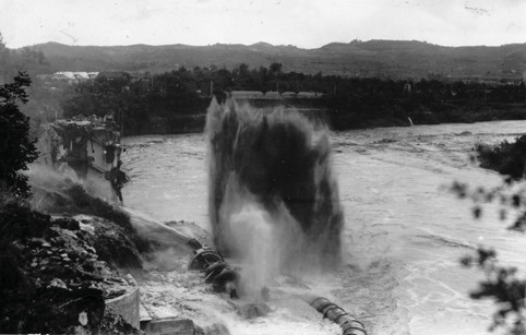
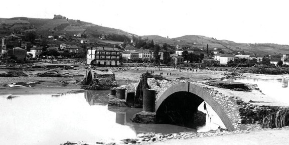
The flood wave destroyed the powerhouse, though its staff had fled just in time (Figure 19) (Bonaria and Tosatti 2013). According to the Carabinieri report, the flood left Sella Zerbino around 1:30 pm, reached Molare and the Ghiaia district of Ovada around 1:55 pm, and reached the Borgo district of Ovada around 2:05 pm (Il Piccolo 2021). The official number of fatalities was 111, though it may have been as high as 115, with most of the victims in the Borgo, on low ground beside the river, where about 60 to 65 died (Figure 20) (Bonaria and Tosatti 2011, 2013; Bonaria 2013; Bonaria, molare.net). However, Petaccia and Natale (2020) put the number of deaths in the most damaged area of Ovada at 73, and the number of victims between Molare and Ovada at 97. About 90 houses and four bridges were destroyed, and damage was estimated at more than 45 million lire, equivalent to about $3.7 million in 1935 U.S. dollars, or about $91 million in 2026 U.S. dollars (Bonaria and Tosatti 2013; Luino et al. 2014).

There was no formal warning system or emergency plan. Warnings depended on ad hoc telephone calls among the dam, the powerhouse, and a small power station in Ovada, and finally on a worker sent on foot, but the authorities were not effectively alerted, and two plant technicians were later charged with failing to give timely warning (Bonaria, molare.net; Il Piccolo 2021). Many residents, accustomed to floods of the Orba, stayed home or climbed onto their roofs (Petaccia and Natale 2020), and eyewitnesses watching from the opposite bank recalled that “the houses opened like books” (Bonaria 2013). Using an empirical loss-of-life model, Petaccia and Natale (2020) estimated that a warning 15 minutes before arrival of the flood wave would have roughly halved the fatalities in Molare and Ovada.
Aftermath and Lessons (Not) Learned
Twelve people were prosecuted: ten designers and managers of OEG and the two technicians (Bonaria and Tosatti 2011). The defense case, prepared by experts including hydraulics professor Giulio De Marchi, rested on hydraulics (Bonaria, molare.net). Geologic reports were prepared after the failure, including one attached to an expert report submitted to the court, which found that the secondary dam was founded on poor rock (Petaccia and Natale 2013), and many experts concluded that the rock was unsuitable (Luino et al. 2014), but the geologic evidence was not given decisive weight in the verdict. Ironically, the engineer who coordinated the defense reports, Luigi Mangiagalli, had assured after the Gleno failure that “dams can be built and managed nowadays with a mathematical level of safety” (Bonaria and Tosatti 2013). In 1938, all defendants were acquitted, with the court attributing the disaster to “exceptional and unforeseeable rainfall” (Luino et al. 2014). The text of the judgment was reportedly lost in a 1994 flood at the State Archive in Alessandria (Bonaria and Tosatti 2011).
The reservoir was never restored, and a small weir built in 1940 about 1,500 feet (450 m) upstream of the saddle now feeds the surviving tunnel (Abbate and Frigerio 2025; Bonaria, molare.net). A 1980 restoration study, which recommended a design discharge of 106,000 cfs (3,000 m³/s), about 3.5 times the original capacity, and a rockfill secondary dam about 180 feet (55 m) high, stalled because of its cost (Bonaria and Tosatti 2011). The main dam was removed from the register of dams in 2005 and has since passed to state ownership, and it now stands as a monument to the disaster (Bonaria and Tosatti 2013; Bonaria 2013). Molare is regarded, along with Gleno, Vaiont, and Stava, as one of the disasters which shaped Italian dam safety legislation (Turconi et al. 2025).
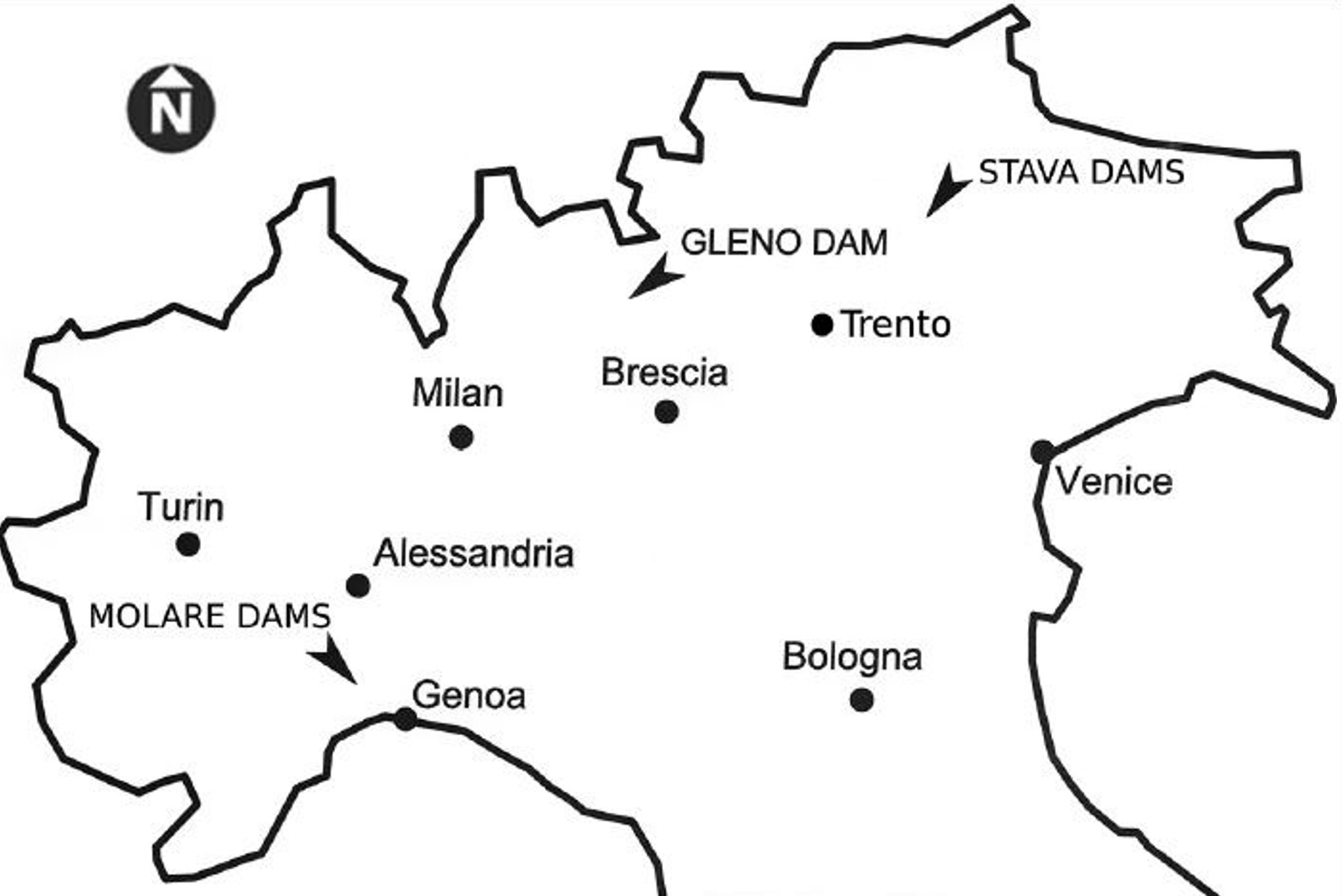
Sella Zerbino shares contributing factors with the earlier Gleno failure (Italy, 1923) and with the later failures at Malpasset (France, 1959), Vaiont (Italy, 1963), and Stava (Italy, 1985), including limited investigation of site geology, design changes made for economic reasons, repeated enlargement of projects (as at Vaiont), and standards and oversight weaker than those of today (Bonaria and Tosatti 2013; Luino et al. 2014). However, the primary causes differ. Gleno was a structural failure, Malpasset a foundation failure without overtopping, Vaiont a reservoir landslide, and Stava a geotechnical failure of tailings dams, whereas Sella Zerbino was triggered hydrologically, through inadequate discharge capacity.
Summary of Physical Factors
- The key physical factors that contributed to the failure can be summarized as follows:
Inadequate discharge capacity: about 30,000 cfs (850 to 865 m³/s), with the 1935 peak inflow roughly three to four times as large. - Reduced outlet performance (the clogged bell valve, the unused bottom outlet, and possibly slow-priming siphons), though with all outlets working, overtopping would have been delayed only about 20 minutes (Petaccia and Natale 2020).
- A secondary dam not designed for overtopping: no toe protection, a steep downstream face, and a crest level with the main dam.
- A foundation in a fault zone: fractured, permeable, erodible rock with weak, soapy mylonite bands, which allowed high uplift beneath the dam and erosion at its toe, and which was rapidly removed once the breach formed.
- Uplift not accounted for in design (Petaccia et al. 2016).
- High consequence potential: about 6,500 acre-feet (8 million m³), nearly half the normal storage, lay above the saddle, and its failure released most of the reservoir (Jansen 1983).
Summary of Human Factors
Applying the human factors framework of Alvi (DamFailures.org), pressure from non-safety goals, combined with human fallibility and the complexity of the project, led to inadequate risk management. Some of the human factors were specific to this project, while others reflect the state of practice and oversight at the time.
Project-specific factors:
- Pressure from non-safety goals: the main dam was raised to increase hydroelectric output, creating the need for the secondary dam, without a matching increase in discharge capacity, and the secondary dam was then designed and built hastily.
- Lack of customization to the site: the originally planned saddle spillway was replaced with a non-overflow gravity dam rather than redesigning the discharge system as a whole, and that dam was founded on rock judged too erodible to be a spillway.
- No detailed site investigation in three decades of planning, although borings were recommended practice at the time (Scimemi 1928, quoted in Bonaria and Tosatti 2013).
- Noncompliance with regulations related to uplift, geologic investigation, and design submittal.
- Missed or dismissed warning signs, unreliable outlets, no rain gauge or flood operations procedures, and no emergency warning system.
State of practice and oversight factors:
- Hydrologic data and design-flood methods were limited (Petaccia and Natale 2020), and regional spillway capacities were generally far below what the 1935 flood demanded (Petaccia and Natale 2013), with design standards based on very rare floods coming later. Even so, the outlets were small compared with at least one contemporary dam, and an early flood had shown them to be marginal (Petaccia and Natale 2013, 2020).
- Rock mechanics was in its infancy (Bonaria and Tosatti 2013), but uplift had been recognized as a significant load on gravity dams since the late 1800s (Léger 2023) and was required by Italian regulations from 1921 (Petaccia et al. 2016).
- Oversight was weak: the Gleno Commission approved filling and called for grouting of the leaks, but no geologic study was required, and the acceptance inspection was not performed at the maximum reservoir level (Bonaria and Tosatti 2011, 2013; Bonaria 2013).
- Geologic expertise was lacking in design, and geologic evidence was not given decisive weight at the trial. Overconfidence was evident, with Zunini promising “absolute safety” in 1899 (Bonaria, molare.net), and Mangiagalli “mathematical” safety in 1923 (Bonaria and Tosatti 2013).
Collectively, these factors reflect ignorance of the actual hydrologic and geologic conditions at the site, complacency in the face of warning signs, and overconfidence, compounded by pressure to increase hydroelectric output and limit cost and schedule. The failure was not the result of an unforeseeable natural event.
Note on Sources
Hydraulic and hydrologic studies (Petaccia and Natale 2013, 2020; Abbate and Frigerio 2025) emphasize inadequate discharge capacity, though Petaccia and Natale (2020) also cite uplift on the fault, while geologic studies (Bonaria and Tosatti 2011, 2013; Luino et al. 2014) emphasize the foundation. Where sources conflict, ranges are given. Jansen (1983) gives smaller heights (main dam 138 feet (42 m) and secondary dam 39 feet (12 m)), but the later, archive-based values are used here. Bonaria (2013) is the most complete account of the archival records. This case study summary supersedes the earlier paper by Alvi (2015).
Other Notes
Units: U.S. customary units are given first, with metric units (as reported in the Italian sources) in parentheses.
Names: the dam is also referred to in the literature as the Molare dam, the Ortiglieto dam, or (in Jansen 1983) “Alla Sella Zerbino.” The surviving main dam is known locally as the “Diga di Molare.” Sources: the sources disagree on several dimensions, times, and quantities, and on the failure mechanism; ranges and competing interpretations are presented in the Description and Background.
References:
(2) Alvi, I. (2015). Failure of Sella Zerbino Secondary Dam in Molare, Italy [Conference Presentation]. 2015 Association of State Dam Safety Officials Annual Conference.
(3) Alvi, I. (2019). Dam Incidents and Failures Can Fundamentally Be Attributed to Human Factors. Association of State Dam Safety Officials. [Cited in the text as “Alvi, DamFailures.org.”]
(4) Annandale, G. W. (2006). Scour Technology: Mechanics and Engineering Practice. McGraw-Hill.
(5) Bonaria, V. (2013). Storia della Diga di Molare: Il Vajont Dimenticato. Erga Edizioni.
(6) Bonaria, V. (n.d.). 13 Agosto 1935: Il Disastro di Molare. [Cited in the text as “Bonaria, molare.net"]
(12) Jansen, R.B. (1983). Dams and Public Safety. U.S. Bureau of Reclamation. 117-119.
(13) Léger, P. (2023). Structural Behaviour, Safety and Rehabilitation of Concrete Dams (course compendium), Polytechnique Montréal.
(14) Luino, F., Tosatti, G., & Bonaria, V. (2014). Dam Failures in the 20th Century: Nearly 1,000 Avoidable Victims in Italy Alone. Journal of Environmental Science and Engineering A, 3(1), 19–31.
This case study summary was peer-reviewed by Lee Wooten, P.E. (GEI Consultants).



Lessons Learned
Concrete gravity dams should be evaluated to accommodate full uplift.
Learn more
Dam failure sites offer an important opportunity for education and memorialization.
Learn more
Dam incidents and failures can fundamentally be attributed to human factors.
Learn more
Forensic investigations are needed for major dam failures and incidents in order to determine the history of the contributing physical and human factors, and the culminating physical failure modes and mechanisms.
Learn more
Gates and other mechanical systems at dams need to be inspected and maintained.
Learn more
High and significant hazard dams should be designed to pass an appropriate design flood. Dams constructed prior to the availability of extreme rainfall data should be assessed to make sure they have adequate spillway capacity.
Learn more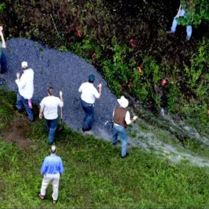
Intervention can stop or minimize consequences of a dam failure. Warning signs should not be ignored.
Learn more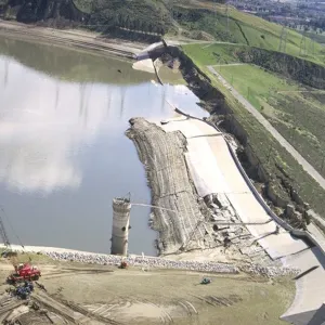
Stability of the dam foundation and other geologic features must be considered during dam design.
Learn more
Timely warning and rapid public response are critical to saving lives during a dam emergency.
Learn moreAdditional Lessons Learned (Not Yet Developed):
- Where a reservoir is retained by more than one structure, the structures should be designed and evaluated as a system: Freeboard should be arranged so that the most overtopping-tolerant structure, or a designated auxiliary spillway or fuse plug on erosion-resistant ground, overtops first, and the erodibility of the foundation and downstream ground of every structure which could be overtopped should be assessed. Here, two concrete gravity dams overtopped by about the same depth behaved completely differently.
The Collapse of the Sella Zerbino Gravity Dam
1935 Sella Zerbino Dam-Break Case Revisited
13th August 1935: A Catastrophic Dam Failure in the Orba Valley (Piedmont, Italy)
Design Flood Estimation
Molare Tragedy
Il Disastro di Molare del 1935 in Valle Orba (AL)
13 Agosto 1935: Il Disastro di Molare

Dams and Public Safety

Failure of Sella Zerbino Secondary Dam in Molare, Italy

Human Factors in Dam Failures



A Guide to Public Alerts and Warnings for Dam and Levee Emergencies

Engineering Guidelines for the Evaluation of Hydropower Projects Chapter 3: Gravity Dams
Gravity Dam Design, EM 1110-2-2200