Mud Pond Dam
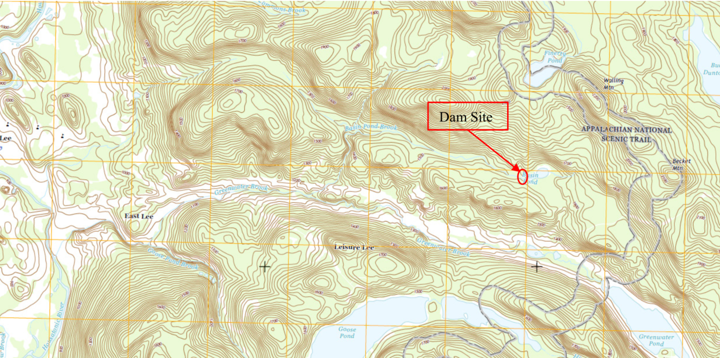
Industry in East Lee in the 1880s depended upon upstream water to power their machinery. Nathan Gibbs, Harrison Garfield, John Dowd, and other mill owners in Lee consolidated their funds and constructed a 10- to 15-foot-high dam in East Lee at Mud Pond (Basin Pond) in about 1883.
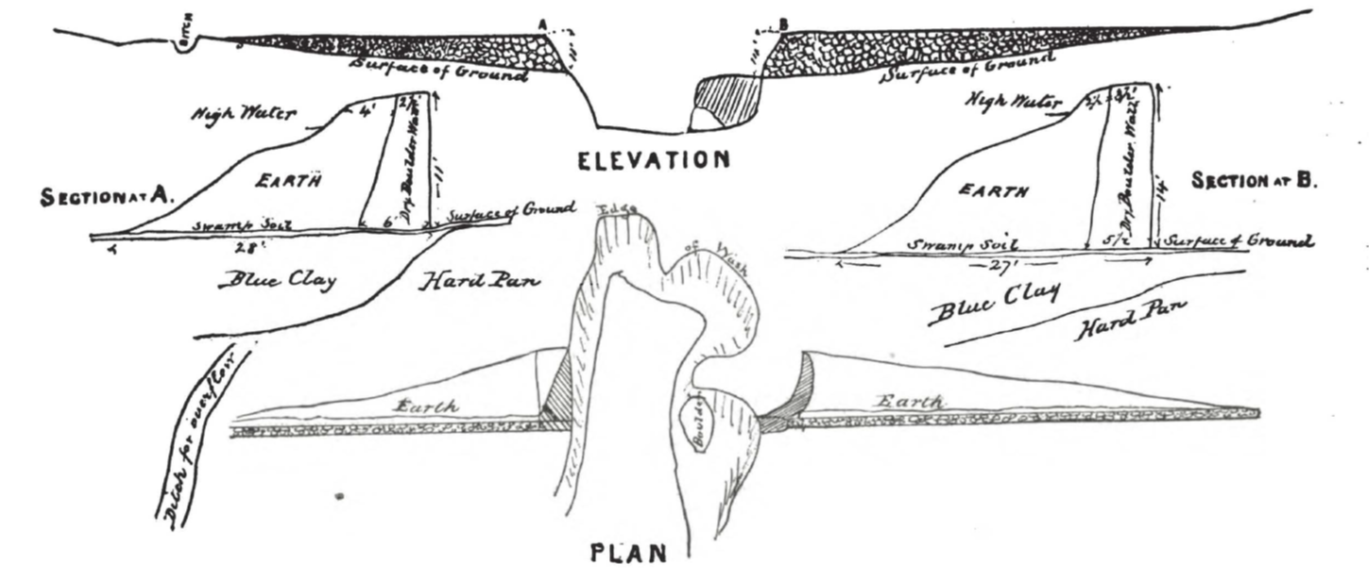
- An embankment constructed with a downstream “dry wall of rough boulders laid together without much care about 6 feet thick at the bottom, and 3 feet at the top” and an upstream zone of earthfill ranging in width from 3 feet at the top to 13 feet at the base, which was on natural ground. Reports on the height of the embankment ranged from 10 feet to 15 feet and the length of the dam was reported as 365 feet.
- An outlet “ditch about 7 feet wide and 3 feet deep … scraped in the soil of the hillside near the northerly end of the dam.”
- A low-level “iron cylinder” outlet pipe with an upstream “fitted gate.”
- Foundation soils described as “a layer of swamp soil a foot or more thick underlayed by a blue clay with a slight admixture of sand (which would have made a good puddle if so used) and this latter underlaid by hard pan with a few boulders.”
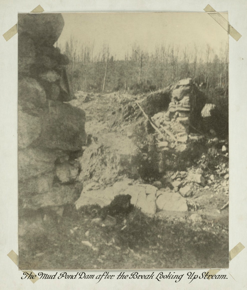
At 5:30 a.m. on Monday, April 20, 1886, Mr. Gonsett, a resident along the upstream part of Greenwater Brook in East Lee, heard and saw an approaching flood, described as a 10-foot-high wall of water, which seemed to gain velocity with its progress, carrying logs, trees, stones, and debris. He quickly warned his neighbors, the Bakers, who escaped and in turn warned other downstream residents (Swept Away by a Flood, 1886).
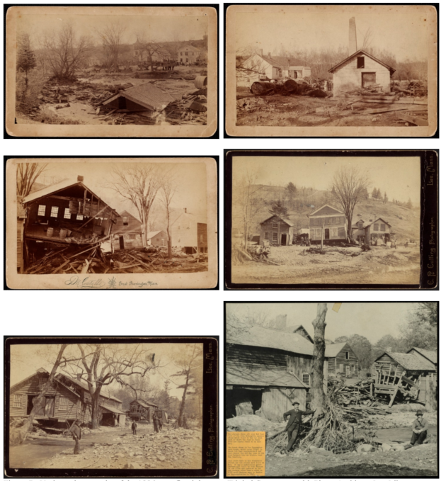
The flood progressively displaced or severely damaged the marble shop of Edwin Sturges, the grinding shop of John Dowd, the Fletcher and Gardner houses, the paper machinery factory of John Dowd, the A.N. White carriage shop, Simeon Dowd’s house, Mrs. James White’s house, the P. Morin store, which served as the local post office, the Couch and Oakley millwright buildings, Freeland Oakley’s barn, the Strickland Hotel, Theron Foote’s grist mill and dam, four tenement houses belonging to the E.& S. May paper mill including the King family residence, the saw-mill and machine shop of John McLauglin, the Harrison Garfield Forrest Mill machine shop and dam, a store, a barn, the Veran fine paper mill, the Decker and Sabin mill and dam, Bottomley’s mill, and E.P. Turner’s machine shop before reaching the Housatonic flood plain where the flood energy dissipated and the severity of damage was less (Swept Away by a Flood, 1886).
The New York Times reported the following causation hypothesis:
The theory of the disaster is that the ground was so thoroughly soaked with water that probably a small stream found its way through the bottom, and, no one visiting the place, this was unnoticed until Gonsett was alarmed by the roar of the water. (Swept Away by a Flood, 1886).
This theory of a seepage induced failure would have relevance again in the 20th century.
The flood killed seven East Lee residents. The A.N. White carriage shop, which also served as the White family home, was destroyed, killing the White parents and their daughters Alice Irene and Ida May, ages 9 and 11. Their son, a 15-year-old, was swept into a tree and recounted that the family had just arisen when they saw the flood approach, having the appearance of an advancing flock of sheep. The family huddled together in their third-floor residence but were carried away when the house pulled apart. Simeon Dowd, their neighbor, died when he left his house to let loose his hens. Mr. and Mrs. Theodore King, their son and daughter-in-law, Mr. and Mrs. Charles King, and their two-year-old child tried to escape their tenement house only to be caught in the flood waters. Both women perished after they were separated from other family members. Charles, his son Theodore, and the two-year old survived (Swept Away by a Flood, 1886).
Property damage included the homes, mills, dams, shops, and other structures mentioned previously and totaled in value $100,000 to $300,000. Liability for the damage became a moot point because the mill owners responsible for the dam were ruined by the flood ([News Report], 1886). The New York Times described the aftermath scene thusly:
In the track of this devastating flood from where it began in Cape-street, through East Lee proper, then to Water-street, where Goose Pond brook intersects, there is hardly a house but is injured more or less, and in the upper part of Cape-street the destruction is more severe. Houses everywhere have from one to six feet of mud on the floors; fences are gone, lawns spoiled, furniture wrecked. and everywhere the work is shown of this unexpected destructive force. On the streams six bridges are carried away, the highways are gullied and in some places are washed away to the depth or several feet. (Swept Away by a Flood, 1886).
The Times also noted that over 5,000 people visited the scene on the following afternoon, “driving in from miles around. All the trains were packed” (Swept Away by a Flood, 1886).

Lake Lee Dam
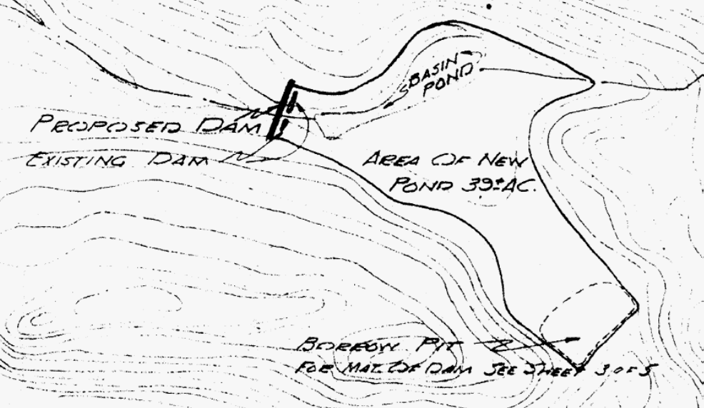
The Berkshires have long been a major vacation attraction and, for many, a vacation home location. In 1965, two Connecticut developers, Hamilton Wright and Walter Cromwell, owners of the Cromwell-Wright Corp., hoped to entice vacation home buyers to East Lee by enlarging Mud Pond with a dam to create Lake Lee with a normal pool volume of about 405 acre-feet. The dam would be at the same location as the previous Mud Pond Dam.
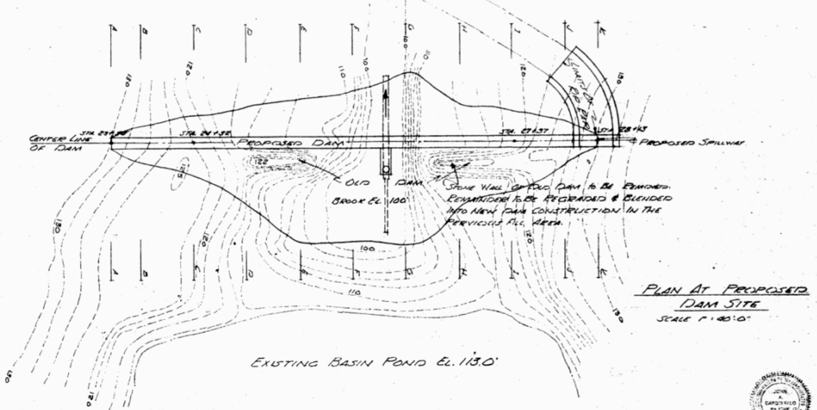
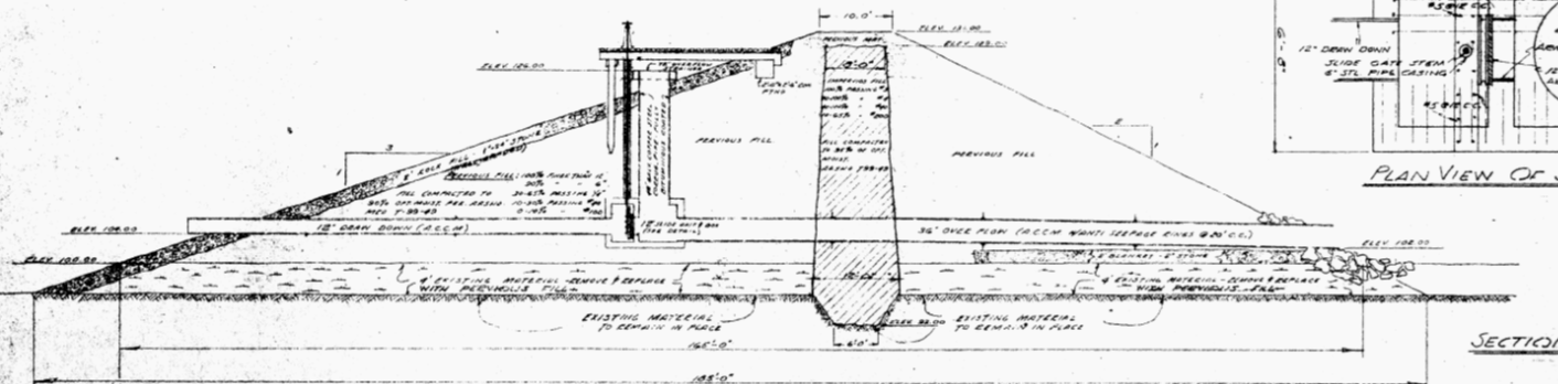
Wright and Cromwell engaged a Connecticut-based engineer, Clarence Welti, to design their dam on the site of the previous Mud Pond dam. That design called for an earth embankment dam, about 475 feet long, with the features described below. These descriptions rely upon the 1968 failure investigation report and attachments prepared by Tighe & Bond, (Tighe & Bond, 1968).
- An embankment with a 10-foot-wide crest at El. 131. El. 100 was the site datum, which roughly corresponded with the natural ground level at the base of the dam. The design called for the following embankment material zones:
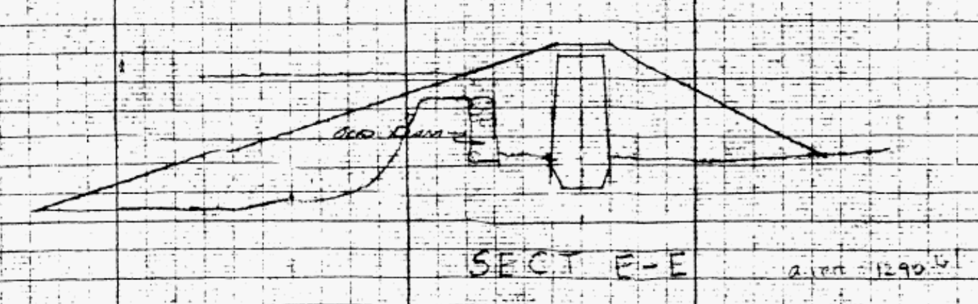
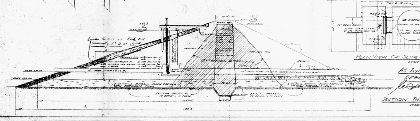
- A central core, keyed about 8 feet below the existing ground surface, to El. 92. The central core design called for “Impervious Fill” with 40% to 65% fines (passing the #200 sieve). The core design varied in width from 8 feet at the top to 12 feet at a depth of 4 feet to a base width of 6 feet at a depth of 8 feet. Beyond requiring a depth of 8 feet, the design did not call for the core to extend to any specific formation for seepage cutoff. The upstream edge of the core would be located about 10 feet downstream of the previous Mud Pond Dam.
- Pervious fill upstream and downstream shells with slopes of 3H:1V and 2H:1V respectively. The pervious fill specs call for gravelly sand to sandy gravel. The top 4 feet of existing soil were to be removed under the pervious shell footprints.
- A 2-foot-thick drainage blanket set within the downstream pervious fill at El. 100. The drainage blanket material is described as 2-inch stone. The blanket extended from the downstream toe to about 10 feet from the core, but the lateral extent of the blanket was not well defined in the drawings. The center section also showed the downstream end of the blanket exiting through a zone that was graphically shown as riprap.
- A 2-foot-thick upstream slope protection blanket of 1-inch to 24-inch stone.
- An outlet consisting of (1) an overflow drop intake at El. 126 at the top of (2) a vertical 48-inch-diameter steel pipe that connected to (3) a concrete gate/junction structure with a base at about El. 102 connected to both (4) a 12-inch diameter, low-level / draw-down intake pipe, which extended to the upstream toe of the embankment, with a gate at the junction structure, and (5) a 36-inch-diameter outlet pipe that extended to the downstream toe of the embankment with three anti-seep collars at 20-foot intervals. All pipes are labelled “A.C.C.M.P.,” which we believe to be asphalt-coated corrugated-metal pipe.
- A riprap-lined overflow spillway at the right end of the dam with a crest at El. 127.
Three preconstruction boring logs are shown on the plans with locations along the dam crest centerline and provided descriptions of peaty silt and gravel, sands and gravel of varying gradations. Refusal was shown on one log at 7.5 feet, and the other two logs stopped at 4 and 5 feet with no note of refusal.
The Berkshire County Commissioners, the entity charged with managing dam safety, approved the dam plans on January 26, 1965.
Whipple Brothers Inc. of Norwalk, Connecticut, constructed the dam starting in the spring of 1965, and engineer’s inspections were reported on seven dates up to a final inspection on September 9, 1965. Inspections noted problems with the dewatering, excavation of a foundation pervious layers, and core placement. Concrete may have been used for lower parts of the core because of these problems, and it was noted that the core base was widened to 60 feet.
The Berkshire County Commissioners continued to perform their dam safety obligations and had the dam inspected on April 26, 1967, an inspection that gave the dam a passing grade (Volpe Views Lee Wreckage, 1968).
In the early afternoon of March 24, 1968, the residents of East Lee were engaged in normal activities for a Sunday – finishing dinner, washing up, tending chores, or pursuing hobbies or games. They had experienced freezing weather over the previous week, which was common for March in the Berkshires, and Friday had brought over one inch of rain to the area.
At about 1:26 p.m., Emily Welch, after getting out of the bath, heard the sound of rushing water, which she initially attributed to a running bath faucet. She soon learned otherwise when she “saw a great black mass of water rushing down the street.” She quickly dressed and, after realizing that she was trapped by flood waters, called the police, who were able to rescue her. Her house, which had survived three previous floods, was washed away (Corea, 1968).
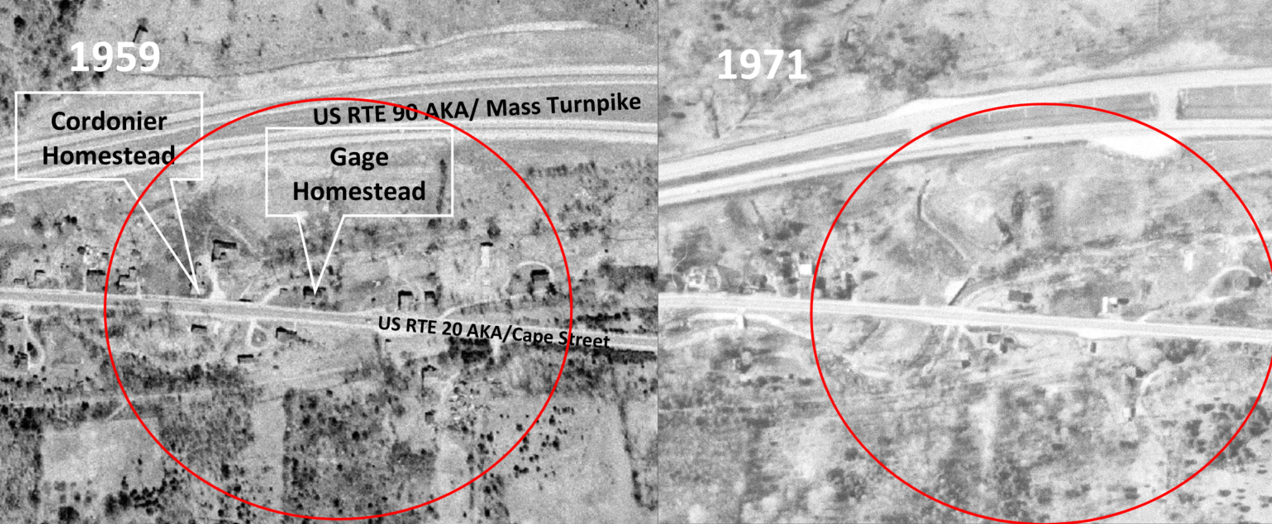
Tom Garrity, a neighbor across the street, saw the flood waters carry a flipped car about 15 feet above a nearby bridge. He told the Berkshire Eagle that the car “was flipping like a peanut.” That car came to rest 300 feet below the bridge. The flood waters trapped Mr. and Mrs. Julius Naventi in their house, which, luckily, withstand the flood forces. Their cars and garage, however, were swept away. George Allen heard the flood and jumped into his truck to warn the residents of his trailer court, which was east on Route 20. The flood caught George’s truck before he could get to the trailer court and carried it across the highway. George survived, as did the trailer court, which was above the flood level. Many of the residents along the flood path had some slight warning and the good sense to flee up the hills behind their houses (Corea, 1968). Shirley Gage was driving home, east on Route 20, when the flood picked up her car and pushed it back down the highway to the west. She survived without injury (Hulick, 1968).
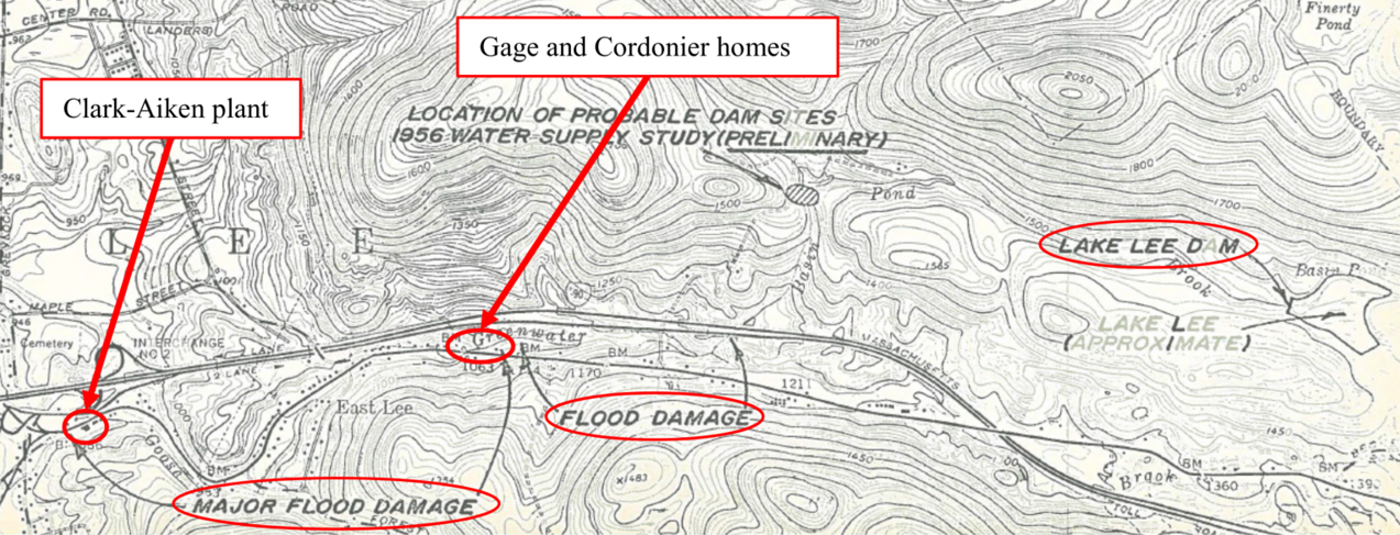
Not everyone was lucky enough to have suffered only property damage. The flood swept the house of Shirley’s father, Edward Gage, completely off its foundation, carrying the intact second floor and attic into the Route 20 bridge. Stephen Gage, Shirley’s twin brother, was awakened by his father as the house started to move. Stephen jumped from the first-floor porch into the flood, was carried downstream, and survived. Edward also attempted to swim from the house, but with fatal consequences. His body was deposited downstream, near the upper part of his house (Marchaud and McLean, 1968). The flood also sliced off one side of the house of Olive Cordonier. Unfortunately, Olive, who had attended church earlier that day, was in the wrong part of the house. Her body was found about 200 yards downstream of the house foundation (Hulick, 1968).
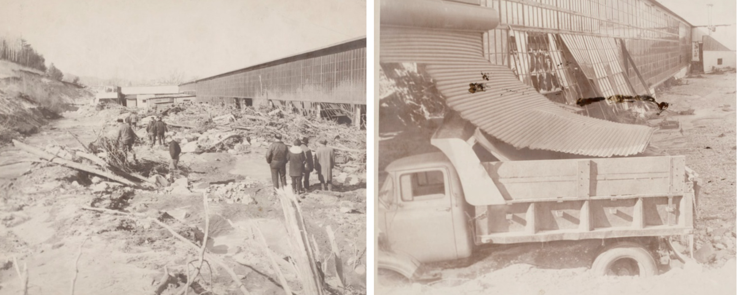
The flood progressed downstream and inundated the Clark-Aiken industrial plant, causing several millions of dollars in damages. The only occupants in the plant, Donald Holcomb and his two sons, ran up to the second floor and survived. The flood forced their car and other debris, including a 16-ton dump truck through the walls of the plant. Residents speculated that the flood would likely have killed many of the 250-person plant workforce if it had occurred on a weekday (Berkshire Eagle, 1968).
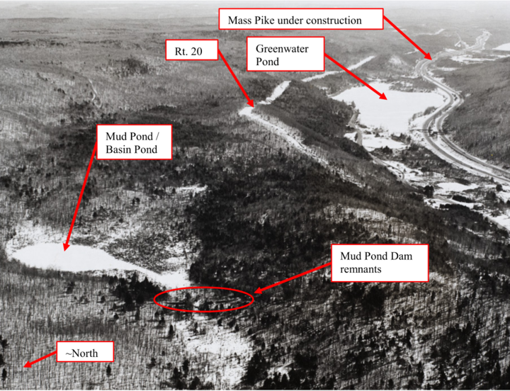
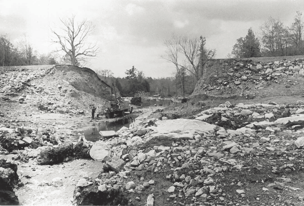
The immediate reconnaissance of the flood led to its obvious source. A breach in the center of Lake Lee Dam had released the lake impoundment on the downstream community. The narrow, steep-sided valleys had conveyed the flood progressively down Basin Brook, under the Mass Turnpike, into Greenwater Brook, under Route 20, under the Tyringham Road bridge, and eventually into the Housatonic River. The major areas of damage were along the Greenwater Pond Brook valley, with much of the damage from the Mass Turnpike bridge to and along Goose Pond Brook (Tighe & Bond, 1968). The fatalities occurred in the neighborhood just upstream of the Route 20 bridge over Greenwater Brook. The flood also damaged the Town of Lee’s new sewage treatment plant on the east shore of the Housatonic River (Hulick, 1968).

The Berkshire County Commissioners engaged Tighe & Bond of Holyoke, Massachusetts to perform that investigation in May of 1968. The investigation findings reported by Tighe and Bond were as follows:
- The dam was not overtopped. Ice level remnants around the lake provided evidence that the Lake Lee level at the time of the breach was below the level of the outlet works intake (El. 126), at least 5 feet below the top of the dam.
- Seepage through the foundation sand and gravel was not cut off by the core construction. This seepage through the foundation soils and from the left abutment was the likely force that triggered the breach.
- The dam construction was “not in keeping with the highest degree of workmanship expected in constructing an earth embankment dam having a vertical shaft and conduit tube-type spillway” (Tighe & Bond, 1968). Tighe and Bond found the following construction deficiencies:
- The core “did not extend to bed rock or to a basic impervious material” even in the central section of the dam where an existing pervious sand layer was found in test pit investigations. A test pit showed that the core was placed on relatively pervious material at this location. The test pit itself did not reach bedrock or a relatively impervious zone but rather stopped on “big cobbles and boulders,” probably because of the “heavy groundwater inflow.”
- The core was not keyed into existing ground as required by the design drawings except in the central section of the embankment with the outlet structure that was washed out. Investigation test pits revealed an organic layer at the base of the embankment, including the core, on both sides of the central section of the dam.
- The embankment fill included sticks and logs and clusters of boulders.
- The concrete walls of the slide gate/junction structure were poorly consolidated below both the intake and outlet pipes, with “voids and rat holes,” which would have allowed seepage from within the structure into the embankment below the outlet pipe.
- “Boulders” (possibly large gravel or cobbles) were observed in the bottom concrete slab of the slide gate/junction structure.
- A tear was observed in the washed-out downstream corrugated metal outlet pipe but was discounted as likely occurring due to the dam failure wash out.
- Even at the time of the investigation, with no upstream impoundment, the toe along the left side of the embankment was very wet from abutment seepage around and over a huge buried boulder.
- The most likely failure mechanism “was the seepage thru and under the dam embankment, coupled with the wet conditions that existed and still exist at the downstream toe of the dam on the west (left) side.” The seepage caused the “wet soils at the toe” to be “washed away.” Tighe & Bond also expected that the stone blanket drainage layer facilitated the seepage flow.
- Frozen ground in the toe area may have also confined and concentrated the seepage.
(Tighe & Bond, 1968).
The failure of Lake Lee Dam led to a major overhaul of the Massachusetts laws and regulations governing dam safety and to Massachusetts’s first state dam safety officials for overseeing the implementation of those laws and regulations.
References:
(2) Knowlton Brothers. (1874). Mill River Flood Stereographs (PH 019) [Photograph]. Special Collections and University Archives, University of Massachusetts Amherst Libraries.
(3) Taylor, J.E. (1874). The Massachusetts Flood, Scenes after the Disaster [Sketches]. Frank Leslie’s Illustrated Newspaper.
(4) U.S. Geological Survey. (2015). East Lee Quadrangle, Massachusetts-Berkshire Co [Video]. U.S. Department of the Interior.
(5) [News Report] (1886). Engineering News and American Contract Journal, Vol. XV, 264.
(7) Watson, W. (1884). Mud Pond Dam. Engineering News and American Contract Journal, Vol. XV, 295.
(8) Swept Away by a Flood. (1886). New York Times.
(9) Lee Library Historical Photograph Collection. (1886). Lee Library Association.
(10) Librizzi, R. J. (ca. 1958-1959). Aerial view of Mass. Turnpike [Photograph]. Berkshire Eagle. Lee Library Historical Photograph Collection.
(11) Tighe & Bond Consulting Engineers. (1968). Report to Commissioners of Berkshire County on Failure of Lake Lee Dam, Lee, Massachusetts on March 24, 1968.
(13) Volpe Views Lee Wreckage. (1968, March 26). Greenfield Recorder Gazette.
(14) Corea, G. (1968) East Lee Somber in Aftermath of Flood. Berkshire Eagle.
(15) Hulick, D. (1968). Second Life Taken by East Lee Flood. Berkshire Eagle.
(16) Marchaud, E. & McLean, J. (1968). Wall of Water Destroys Homes. Boston Herald-Traveler.
(17) Marchaud, E. & McLean, J. (1968). Flood Victim’s Son Swims to Safety. Boston Herald-Traveler.
(18) Marchaud, E. & McLean, J. (1968). Third Flood at Dam Site. Boston Herald-Traveler.
(19) Bielinski, R.J. (1968). Rescue Workers. Boston Herald Traveler.
(20) Clark-Aiken Plans to Rebuild in E. Lee. (1968). Berkshire Eagle.
(21) Lee Library Historical Photograph Collection. (1968). Lee Library Association.
(22) Sanders, V. (1975). Old English law throws new light on suits in E. Lee dam disaster. Berkshire Eagle.
(23) Berkshire Natural Resources Council. (2006). New Basin Pond Trail.
(24) Commonwealth of Massachusetts. (1854). Chap. 327. An Act relating to Mill and Reservoir Dams.
(25) Commonwealth of Massachusetts. (1875). Chap. 178. An Act to Provide for the Supervision of the Construction and Maintenance of Reservoirs and Dams.
(26) Uncertainty in Boston Clouds Study of Lee Flood. (1968). Berkshire Eagle.
This case study summary was peer-reviewed by Greg Richards, P.E., CFM (GFT).
Lessons Learned
Dam incidents and failures can fundamentally be attributed to human factors.
Learn moreAdditional Lessons Learned (Not Yet Developed)
- Poor design and poor construction of dams should never be allowed. The Massachusetts dam safety regulations prior to 1970 placed the responsibility for dam safety regulation on the County Commissioners, a group poorly equipped to understand dam engineering. The County Commissioners, in turn, relied on their County Engineer, again, an individual who typically lacked specialized dam safety engineering training, and on the owner’s engineer.
- Engineers charged with designing and monitoring dam construction must address all site difficulties and insist on construction that follows those designs using frequent and, when appropriate, continuous monitoring. The Lee Dam construction did not adhere to the design requirements despite periodic site visits by the owner’s engineer.
- Control of seepage to prevent internal erosion and to enhance stability is critical for dam safety. The post-failure investigation revealed highly pervious layers in the soils under Lake Lee Dam. These features allowed seepage conditions that appear to be the cause of the 1968 failure and, most likely, the 1886 failure. We don’t know if the seepage conditions induced internal erosion / piping loss of foundation or embankment soils or if seepage pressures destabilized the downstream embankment slope, two likely failure modes. Several elements of the design and construction of the Lake Lee dam failed to adequately address seepage.
- Distance from even a modest sized dam and reservoir will not provide significant mitigation of a flood wave if valleys are steep and narrow as was the case downstream of Mud Pond/Lake Lee.