Introduction
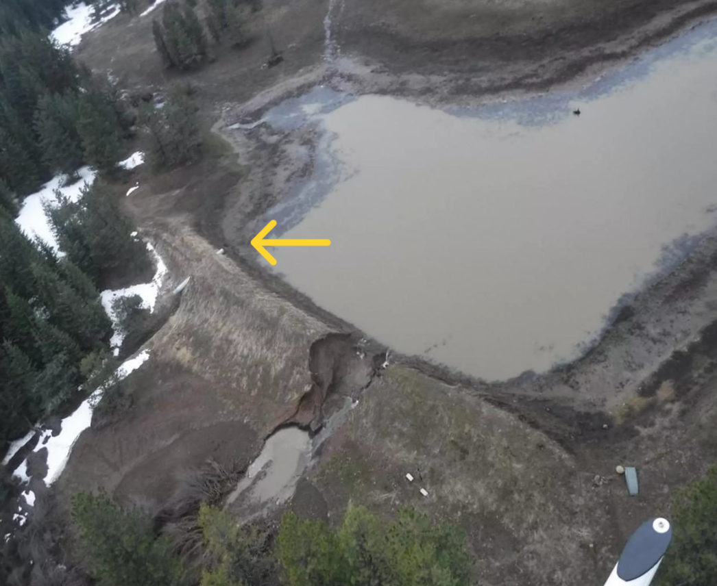
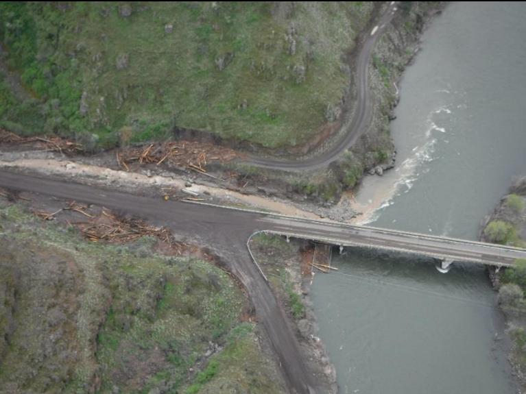
The dam at Bonasa Breaks Ranch, located in a remote section of Asotin County in southeastern Washington, breached on the early morning of Thursday, April 13, 2017. An ensuing flood wave traveled down the narrow Rattlesnake Creek Canyon along State Highway 129 and emptied into the Grande Ronde River. Timber debris and sediment was scattered throughout the area at the base of the canyon. The breach and path of destruction was captured on the same day in a video from a helicopter taken by the Asotin County Conservation District (ACCD). An interdisciplinary investigative team from the State of Washington Department of Ecology (DOE), Dam Safety Office (DSO) was dispatched to the site on May 3, 2017. DOE produced a report in August 2017 documenting the dam failure and summarizing their hydraulic and hydrologic analysis. Approximately four years later, Exponent, Inc. conducted a forensic evaluation of the cause and contributing factors as part of civil litigation, issuing a causation report in October 2021.
Background
The earthen dam, originally used to form a stock pond, existed as early as the 1960s. The dam is generally aligned in a NNE-SSW direction with the reservoir on the western side. Based on air photos, the original surface area of the reservoir was estimated to be approximately 1.2 acres. The height of the original dam was unknown but the reservoir volume was estimated to be 10 acre-feet or less. It was reported that an emergency overflow section was located in the right abutment.
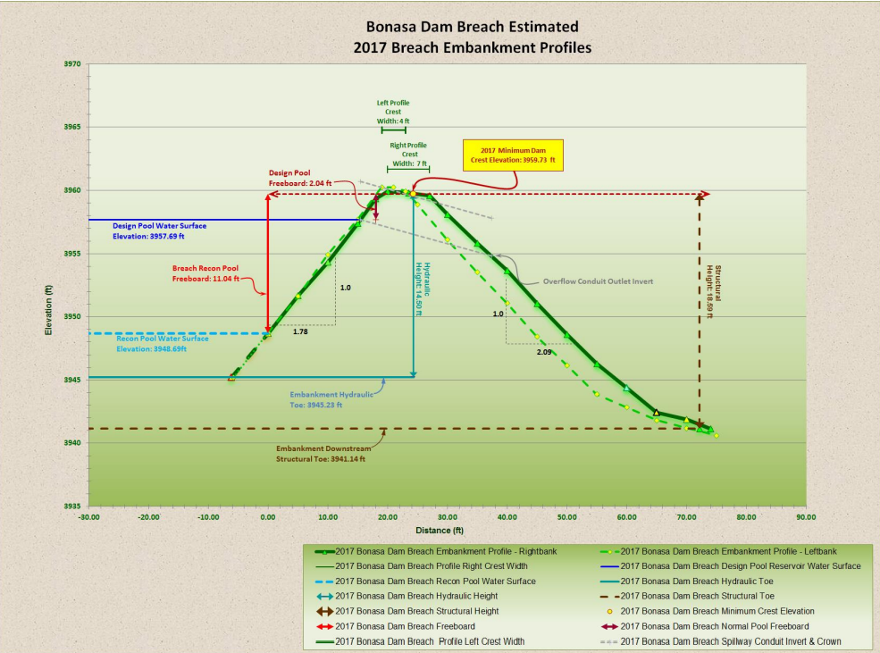
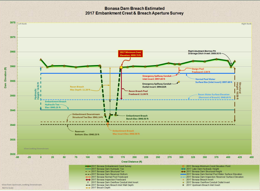
The embankment was raised to a structural height of 19 feet in 2006-2007 in two or three stages. The embankment raise consisted of a non-zoned section of homogeneous earthfill, composed primarily of silty sand and sandy silt. The crest length was 414 feet and the crest width ranged between 4 and 8 feet. The upstream and downstream faces had average slope ratios of approximately 1¾ H:1V and 2H:1V, respectively. There was no slope protection other than natural ground cover. Circa 2010, a depression of approximately 5 feet deep in the general area of the future breach was reported to have been re-graded and no signs of additional ground movement were reported prior to the breach.

A 3-foot-diameter corrugated metal pipe was installed within the raised section of the embankment to serve as an outflow conduit. The upper and lower ends of the conduit extended several feet beyond the embankment. The invert elevation of the conduit at the reservoir was 2 feet below the lowest crest elevation. There was no low-level outlet found.
The dam raise increased the reservoir surface area to 4.3 acres with a capacity of 18.3 acre-feet, exceeding the State’s DSO jurisdiction threshold of 10 acre-feet. However, the 2006-2007 dam raise was unknown to DSO and unpermitted. There is no documentation of engineering design or construction control having been performed.
Incident
The Owner of the dam testified that a day or two prior to the breach, water was flowing through the CMP outlet less than half-full. Since the dam raise, water was never observed to flow over the crest of the embankment.
No one observed the failure. The first report of a problem was flooding at State Highway 129 at the Grande Roche River at the state line with Oregon. Helicopter reconnaissance by ACCD discovered the dam failure.
Beyond the dam, damage to the canyon included timber felling, sedimentation, and loss of wildlife and wildlife habitat.

Observations, Measurements, and Calculations
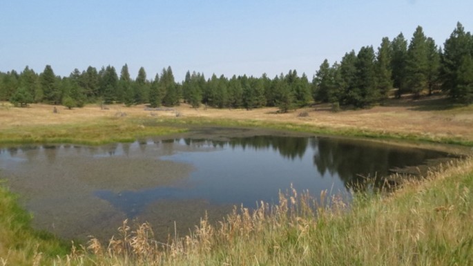
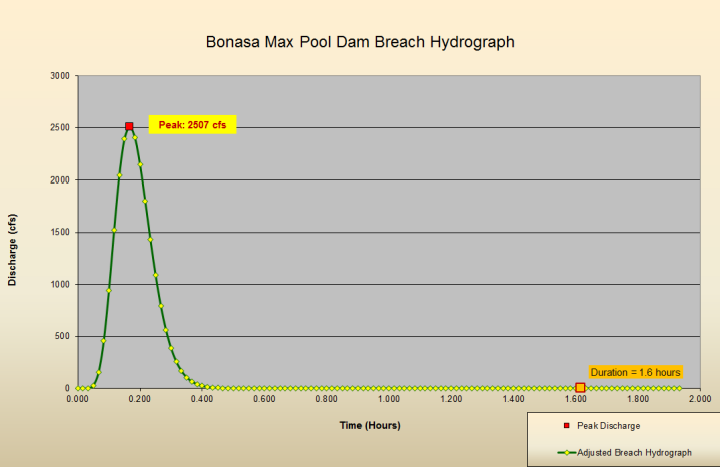
The breach was U-shaped and located approximately 125 feet from the north abutment. The breach in the embankment was 43 feet across at the crest and 23 feet across the bottom and had a maximum depth of 20 feet. The base of the breach exposed bedrock. DSO estimated the peak breach outflow to be approximately 2,500 cubic feet per second.
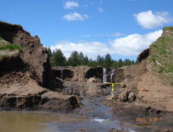
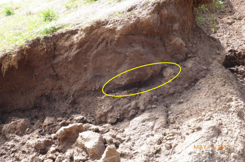
DSO observed buried organic material and sloping contacts between fill lifts, likely at the contact between the original dam and 2006-2007 dam raise, and “tube-like” features on the margins of the breach. There was no evidence of benching or filters. Although not noted by DSO, Exponent observed a considerable number of burrow holes on the upstream slope four years later. However, these bores existed below the normal pool elevation and were likely created after the breach.
A high water mark was surveyed by DSO at 0.72 feet below the lowest measured (remnant) crest elevation at the margin of the breach. Given the narrow width of the breach and height of the embankment, it is unlikely that the dam overtopped. DSO also observed matting of the vegetation on the downstream slope. However, the area had recently experienced rapid snowmelt which could have caused this feature. There were no signs of erosion rills or gullies in the embankment slope or groins. Furthermore, vegetation was matted (from snow) in other areas outside the influence of reservoir water.
The reported 2010 ground depression suggests a serious problem with the stability of the embankment. Based on historical precipitation records, the highwater level in the impoundment preceding the failure had also likely been reached on numerous occasions prior to the failure. However, there do not appear to be additional observations of instability over the intervening 7 years of operation.
DSO measured the drainage area to be 0.2236 square miles (143 acres) with a mean annual precipitation of 21 inches. A 2-year, 24 hour storm is 1.275 inches and a 2-year, 2-hour storm is 0.509 inches.
Maximum late-winter snowpack (April & May) is typically 3.9 inches deep with a 20 percent water content of 0.78 inches. A review of precipitation records indicated approximately 0.63 inches of precipitation fell during the 14 days prior to the breach with the most intense rainfall being approximately ¼ inch over a few hours on the day of the breach.
Findings and Conclusions
The breach appears to have formed by progressive backward erosion piping propagated during periods of high hydraulic head, including April 2017. This phenomenon likely occurred progressively over the 9 to 10 years that the dam was in service. More broadly, the breach was caused by a combination of (a) the absence of engineering design; (b) improper earthwork; and (c) the lack of engineering oversight, monitoring, and testing during construction.
References
(2) Exponent, Inc. (2021, October 11). 26(a)(2)(B) Expert Report, David W. Sykora, Ph.D., P.E., D.GE; Halsey, et al. v. Croskrey and the Bonasa Breaks Ranch, Asotin County, WA.
This case study summary was peer-reviewed by Irfan Alvi, P.E. (Alvi Associates).
Lessons Learned

Dam incidents and failures can fundamentally be attributed to human factors.
Learn more
Regular operation, maintenance, and inspection of dams is important to the early detection and prevention of dam failure.
Learn moreAdditional Lessons Learned (Not Yet Developed)
- Dams require proper design by qualified professionals.
- Dams must meet requirements established by the State DSO, including permitting.
Bonasa Breaks Ranch Dam: Dam Failure and Hydrologic Report