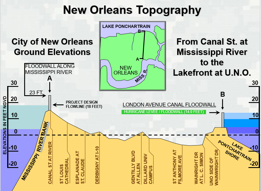
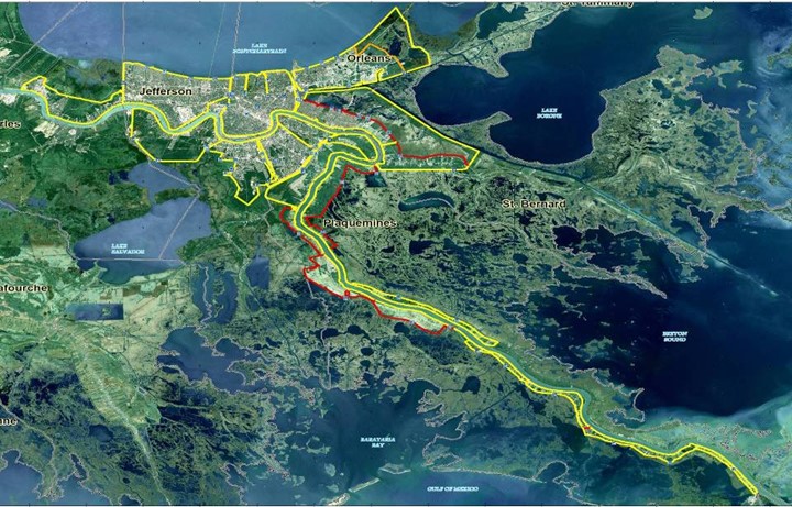
A sprawling collection of levees of varying size, construction, and ownership were constructed in the Mississippi delta near New Orleans over a period of over 200 years, mostly on low land reclaimed from the salt marshes and bayous, but some like the higher sandbar deposits in the “Crescent” where the downtown area was developed. The levees were “a system in name only”, as they were not planned, designed, or constructed to be operated or perform as integrated elements. The levees were connected in a collection of polders that were further subdivided by interior drainage canals with secondary lines of protection. Additionally, the east and west bank levee systems were not complete in 2005 – several gaps existed that would allow leveed areas to be inundated depending on the direction and intensity of a hurricane. Development intensified in the area due to the rapid growth of the fisheries, gas, port commerce, and tourism industries resulting in an urban population of almost 500,000 people by 2005.
The hazards of the area are multiple including:
- The combination of the soft, compressible organic soils and the intense development has resulted in more than half of the ground surface in the protected area behind the levees to be below sea level by as much as 10 to 12 feet in locations.
- The levee system is subject to both heavy riverine flooding from the Mississippi River and its tributaries as well as coastal flooding from surge and wave action from tropical events in the Gulf of Mexico.
- Since the area forms a bowl below sea level, all the rainwater (average exceeds 60 inches annually) and interior drainage must be pumped up and out of the protected development behind the levees.
- The complexity and uncertainty of the physical infrastructure in 2005 was significant given the presence of multiple governing authorities at the federal, state, and local levels; the enormous area and size of the levees; the presence of more than 200 closure structures in the line of defense; land development and real estate pressures; the age of the system; and the lack of a modern and uniform set of safety practices and standards nationwide.

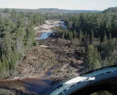
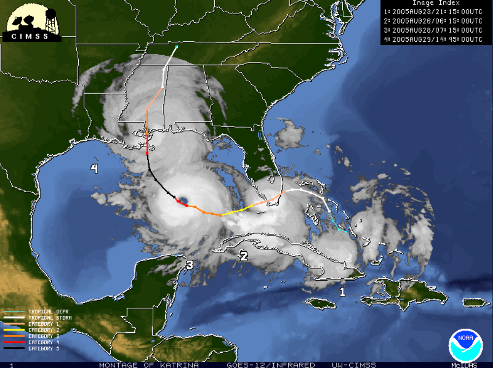
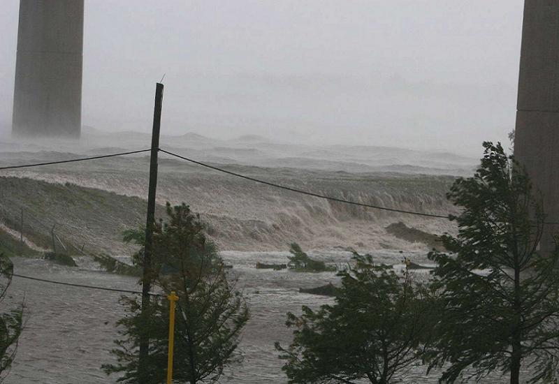
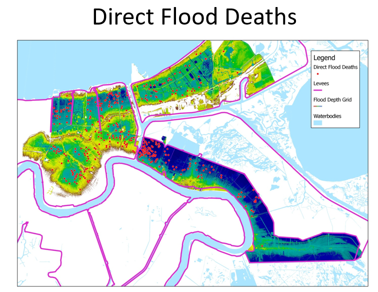
During August of 2005, Hurricane Katrina made landfall just south of New Orleans, Louisiana resulting in the largest release of energy ever recorded in North America. The CAT 5 hurricane caused storm surge and wave impacts of 15 to 28 feet across the Mississippi River delta region that was estimated to be between a 50-year and 500-year recurrence interval depending on the location within the region. The hurricane caused a reversal of flow (upstream) of the Mississippi River. Multiple locations within the levee system were breached during Hurricane Katrina resulting in over 1,800 lives lost, billions in economic damage, and a long-term redistribution of over half the city’s population. Downstream of the city of New Orleans and closer to the storm surge, Plaquemines Parish levee system was overtopped by the reversal of flow in the Mississippi River.
Failure Modes
Multiple high-level assessments have been done on the performance of the levee system and the causes of failure. The following is a summary of the consensus causes for the failures and some of the safety lessons and advancements related to these failure modes.

Failure Modes Related to Overtopping:
Over 50 breaches in the levee system were documented, with 46 of them due to overtopping and overwash by the heavy coastal storm surge and wave attack. Overtopping and breach was attributed to settlement and subsidence issues in the crest of the levees, erodible levee materials in the surface of the levees, gaps in the line of defense, lack of a full understanding of hydraulic conditions including surge behavior and the effect of long period waves, flow concentrations at transition points between differing levee sections, the lack of armoring behind floodwalls, and loss of the land and vegetation around the perimeter of the system that offered a natural buffer to coastal surge and waves.
Failure Modes Related to Performance Prior to Overtopping
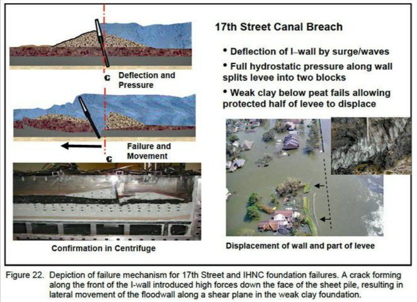
Four of the 50 breaches occurred prior to overtopping in areas along the interior drainage canals where I-walls had been constructed on top of earthen levees, and these four locations accounted for approximately 75% of the fatalities. These “prior to overtopping” failure modes were identified as follows:
- Three failure modes occurred due to an unaccounted-for exploitation of the soil structure interface of the I-wall and earthen levee. Under flood load, the formation of a gap at the face of the buried I-wall permitted hydrostatic forces to penetrate down into the levee embankment section and foundation, increase driving forces, essentially splitting the section, and resulting in a rapid sliding failure of levee. The formation of the gap was observed during the E-99 full scale load tests of the I-walls during design but was not understood as a soil-structure interface concern that could cause failure of the levee, nor was it addressed in standards at the time. Today, the integration of design considerations and disciplines offered by modern risk informed practice and standards would likely illuminate and resolve this failure mode.
- One of the failures prior to overtopping was attributed to internal erosion (backward erosion and piping) and uplift caused by the presence of continuous, highly permeable zones in the alluvial foundation soils.

Other Factors Contributing to Risk Posed by the System:
Several global factors were identified as contributors to the overall risk and uncertainty in the levee system and the communities in the New Orleans area, including:
- Incremental funding of the levee construction over a span of decades created a system “in name only” with some of the planned system incomplete.
- Plan formulation practice and environmental considerations which didn’t adequately consider life safety concerns in the alternative selection process.
- A National Flood Insurance Program which unintentionally supported a false assurance of safety.
- Fractured governance systems within the local, state, and federal authorities which led to uncoordinated responses, miscommunications, and a variety of standards.
- Local affordability which impacted operation and maintenance effectiveness.
- Reduced public awareness and communication of flood hazards in a community that has high flood risks.
- A system designed with standards of the day that didn’t include an understanding of failure modes and risk analysis.
- Management of navigation interests within canals and waterways which didn’t account for adjacent levees.
- Land development practices which privatized real estate gains for developing in high-risk areas while socializing flood losses. This included constraints on real estate needed for levee construction and the encroachment of invasive development (swimming pools, etc.) in the levee template.
- Inadequate evacuation effectiveness because of low public awareness, ineffective and untested plans, and uncoordinated evacuation procedures, particularly for the elderly, poor, and under-served people in the community.
- Inadequate emergency preparedness in the form of communication of flood extents and depths, egress routes, shelter in place options, rescue operations, and recovery facilities.
Lessons and Advancements as a Result of the Levee Failures
- New analytical techniques have been developed which can evaluate a suite of synthetic and observed storms in a probabilistic framework including their impact on surge and wave effects, permitting system wide evaluations of complex projects.
- It can be more effective to address large coastal storms beyond the perimeter of developed areas rather than at the limits of development. Other important hydraulic considerations include physical interaction of system elements, human factors in operating closure structures, the effect of deep, broad floodplains, transition points in the line of defense, coincidence of riverine and coastal flooding events, and long period waves.
- It is critical to understand soil-structure interactions, particularly related to potential failure modes in systems with I-walls embedded in earthen levees.
- Improved risk analysis techniques and tools for levees that more fully integrate probabilistic hydrologic loading, system performance, and consequences can provide a clear identification of system vulnerabilities.
- It is important to understand the significance of social science factors in assessing risks behind levees, including emergency messaging, building public awareness of risks, emergency response and rescue, sheltering in place challenges in deep floodplains, and the impact of human behavior on evacuation effectiveness.
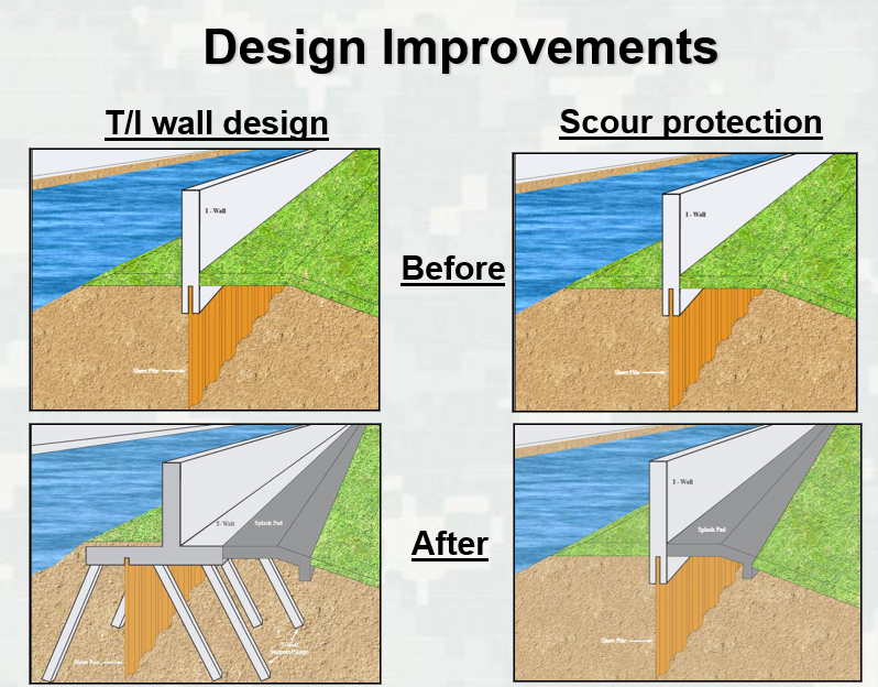
- Improved guidance, policy, and practice has been developed for evaluating and designing risk reduction measures that are more resilient to overtopping and overwash effects including surface armoring, armoring of transition points, armoring behind floodwalls, and design of intentional overtopping locations.
- Improvements in governance include consolidation of levee boards, increased coordination and communication, improved stakeholder engagement, and better understanding of roles and responsibilities among all levels of government.
- A better understanding of the importance and role of natural systems of vegetation and land accretion on the coastal side of levee systems in reducing flooding effects. This had led to improved nature-based solutions.
- Since 2005, over $15 billion of federal funds have been invested in rebuilding and upgrading the flood defense system of New Orleans that have addressed all the identified failure modes and most of the risks (overtopping risks have been substantially reduced through superiority, improvements in transitions, and erosion resistance). The focus of reconstruction was to address the failure modes, design with a focus on system performance, provide additional resilience, robustness, and redundancies in the system, ensure that the system had a consistent level of flood risk reduction with consideration for long term settlement, subsidence, and sea-level rise, and increase the reliability of the interior drainage systems.
- Additionally, the event spurred a report to Congress on Recommendations for a National Levee Safety Program (NLSP) and a new law entitled the Levee Safety Act. In turn, the federal government has begun implementation of a National Levee Safety Program which includes a state-of-the-art National Levee Database, new risk informed guidelines on levee safety programs including governance, assessment, management, and communication of risks (specifically Risk Informed Design ECB 2019-15 and Levee Safety EC 1165-2-218), improvements to the National Flood Insurance Program, and increased funding for levee inspections, assessments, and repair. The NLSP remains a work in progress.
References:
This case study summary was peer-reviewed by Rich J. Varuso, P.E., U.S. Army Corps of Engineers.
Lessons Learned

Dam incidents and failures can fundamentally be attributed to human factors.
Learn more
Dams should be thoroughly assessed for risk using a periodic risk review process including a site inspection, review of original design/construction/performance, and analysis of potential failure modes and consequences of failure.
Learn more
Earth and rockfill embankment dams must be stable under the full range of anticipated loading conditions.
Learn more
Emergency Action Plans can save lives and must be updated, understood, and practiced regularly to be effective.
Learn more
The hazard classification of a dam can change over time (hazard creep).
Learn more
Timely warning and rapid public response are critical to saving lives during a dam emergency.
Learn more

A Guide to Public Alerts and Warnings for Dam and Levee Emergencies