Background
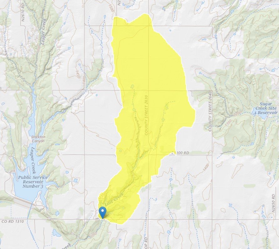
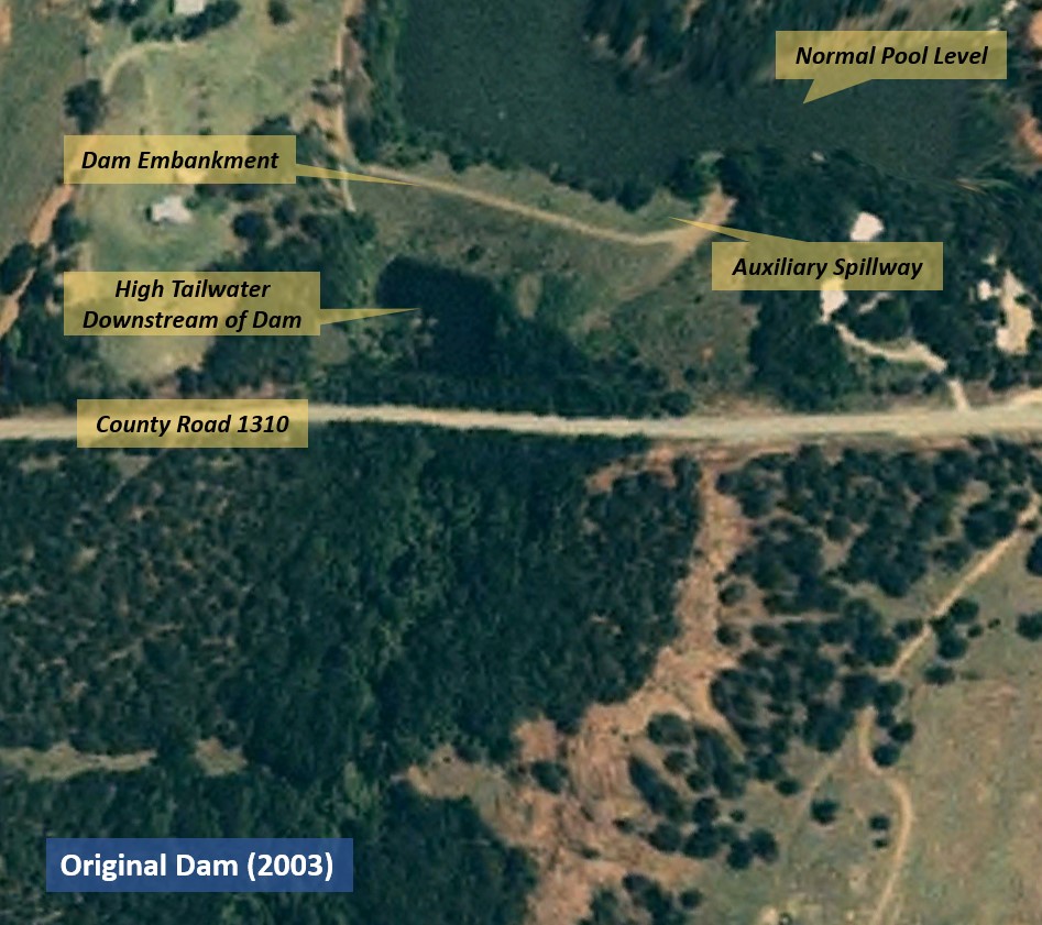
Sugar Creek Watershed Dam No. L-44 (Sugar Creek Dam) is located approximately four miles northwest of Anadarko in Caddo County, Oklahoma. It is one of 51 flood control dams in the Sugar Creek watershed. The dam was first constructed in 1971 by the local conservation district with assistance from the Natural Resources Conservation Service (NRCS). The dam embankment was constructed of sand or silty sand with a silty clay core. The 40-foot-wide, earth-cut auxiliary spillway was excavated into the silty sand overburden of the left abutment. It was initially classified as having low hazard potential but was subsequently reclassified in 2005 as having high hazard potential after a few homes were constructed in the downstream inundation area. The dam was not rehabilitated or modified to meet high hazard design criteria at the time of reclassification.
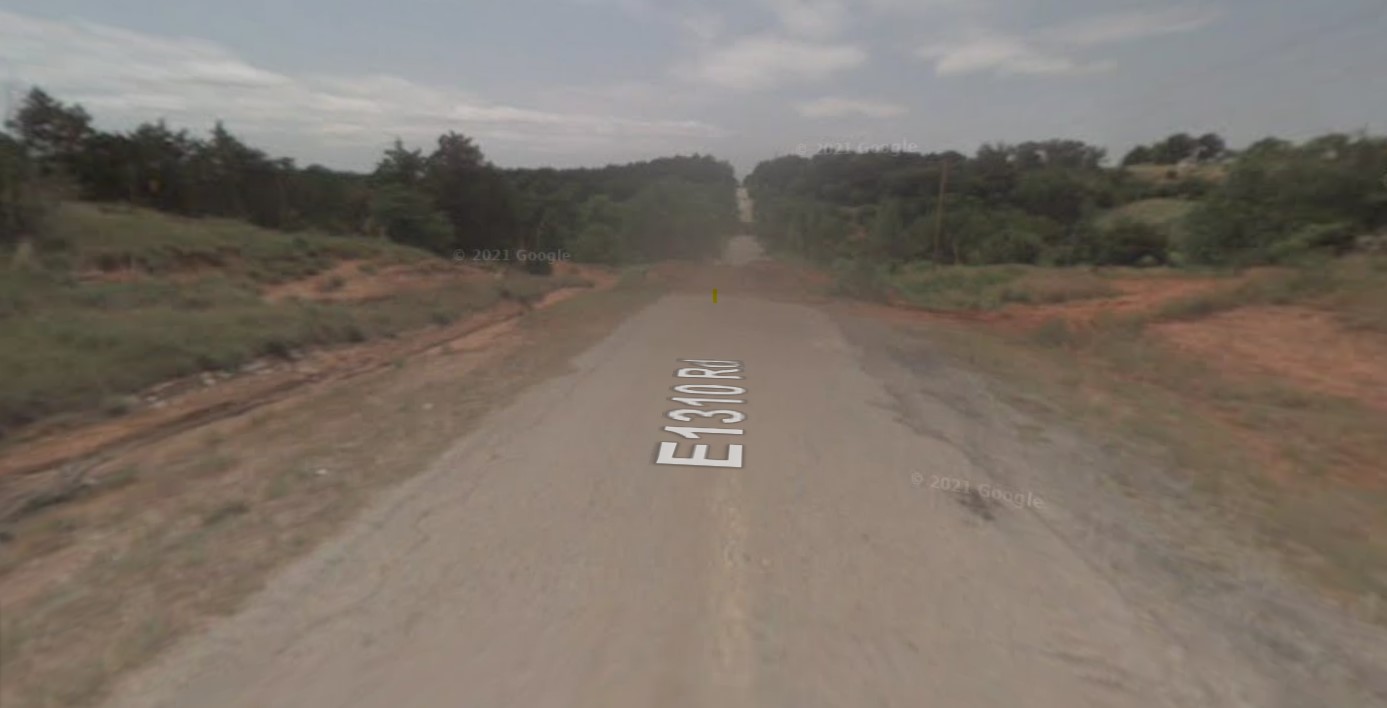
Prior to construction of the dam, a 78-inch culvert carried water under the road embankment of County Road 1310. As early as 1972, however, problems began occurring due to sedimentation and backwater created by the County Road submerging the principal spillway outlet of the dam. Later in the 1970s, the County installed a supplemental 24-inch culvert through the road embankment; however, its invert was reportedly 15 feet above that of the principal spillway outlet which did not alleviate the submergence. In 1987, the downstream road was completely washed out during a flood, though no damage to the dam or spillway were reported. The County repaired the road in 1988 and replaced the 24-inch culvert with an even smaller 18-inch culvert. Backwater conditions at the toe of the dam and principal spillway outlet persisted until the 2007 incident. The original 78-inch culvert was never found after the 1987 event.
Incident
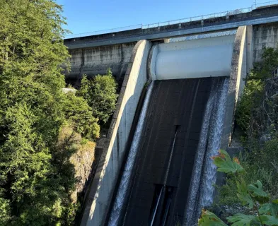
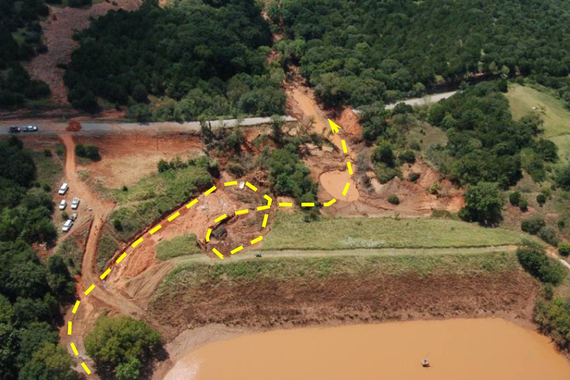
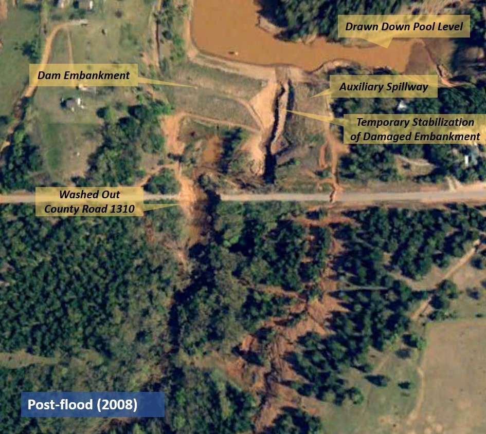
On Saturday, August 18, 2007, tropical depression Erin swept across Oklahoma. Many parts of central Oklahoma received record precipitation with totals from the storm exceeding 13 inches in some areas. In the drainage area above Sugar Creek Dam, it is estimated that 8.3 inches of rain fell in about six hours (corresponding to a storm less frequent than the 10-2 annual exceedance probability storm or a flood that is larger magnitude than a 100-year return period event). This caused activation of the auxiliary spillway with a maximum flow depth estimated between 2.6 and 3.6 feet. Debris plugging the culvert under County Road 1310 resulted in even higher tailwater than usual. Consequently, the auxiliary spillway outlet and downstream slope of the dam embankment were saturated, thereby decreasing the stability and erosion resistance of these soils. When the road overtopped and washed out at approximately 8:15 AM on Sunday, August 19, tailwater levels receded rapidly exposing the saturated soils of the spillway and embankment toe to increased velocities from the spillway outflows.

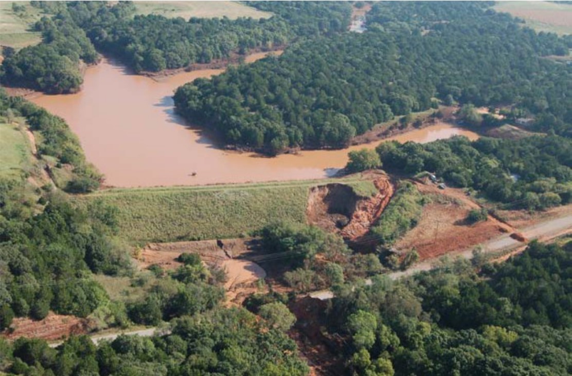
Flows from the auxiliary spillway were discharged beyond the toe of the earth embankment but were redirected towards the dam after encountering the remaining embankment of County Road 1310. While the exact progression of the incident is unknown, flows eventually caused erosion and headcutting of the majority of the spillway exit channel as well as failure of the right spillway dike which protected the dam embankment from spillway flows. The silty sands that the auxiliary spillway had been excavated into eroded easily to the underlying sandstone bedrock, concentrating flows in the right or inside edge of the spillway. This bedrock was erosion resistant, but also sloped steeply towards the dam embankment which further accelerated erosion of the dam.
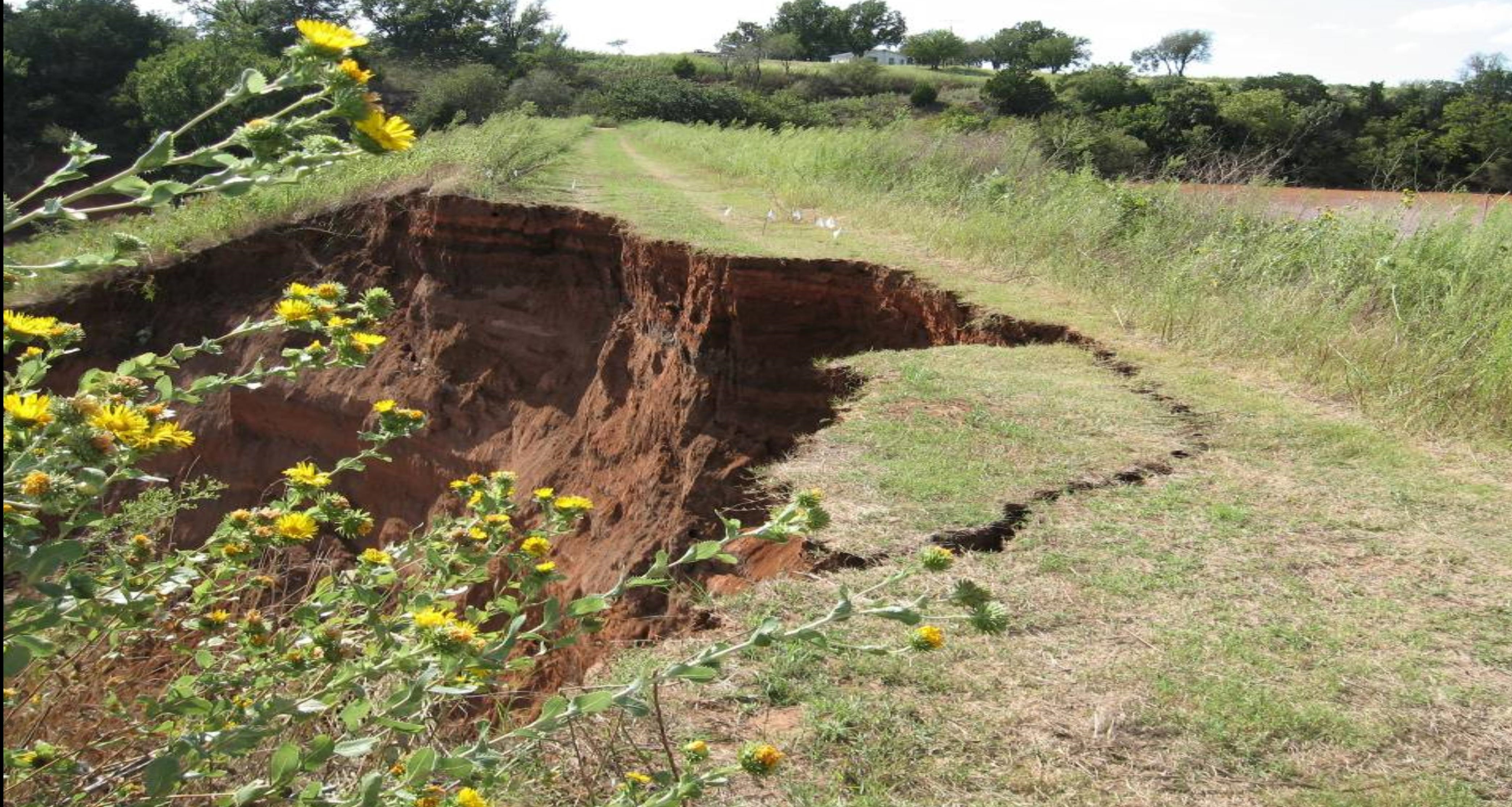
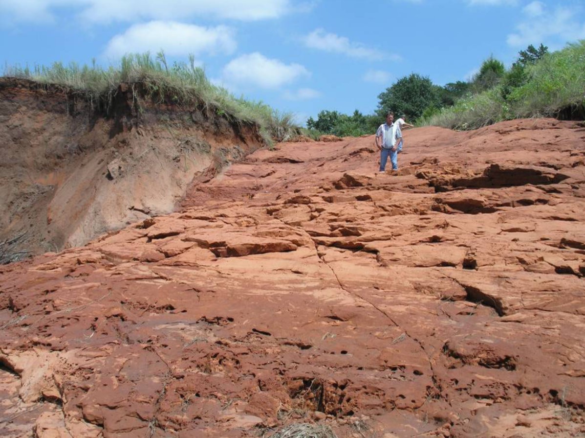
Spillway outflows eroded the downstream slope of the dam and nearly breached the dam. Ultimately, the erosion advanced through more than half of the width of the dam embankment crest within four feet of the dam crest's upstream edge. By 8:00 AM on the morning of Monday, August 20, flood flows had receded, and discharge was no longer occurring within the auxiliary spillway. Had spillway flows continued much longer, the dam would have failed due to erosion and instability of the remaining embankment material. As shown in the accompanying photographs, the eroded portion of the embankment was nearly vertical and highly unstable. It was certainly fortunate that the dam did not fail given the extent of erosion and level of the flood pool.
It should be noted that the original contract drawings for Sugar Creek Dam included a critical revision in the auxiliary spillway location and layout. The following modifications to the initial design were made during construction:
- the spillway was shifted 95 feet towards the embankment along the centerline of the dam,
- the spillway outlet channel was rotated approximately 10 degrees towards the dam embankment, and
- the exit channel slope was increased from 7.5 degrees to 9.75 degrees.

All these changes were probably made to facilitate construction of the spillway but are also likely contributors to the problems at the dam during the 2007 flood. In fact, the 95-foot shift in spillway location resulted in the placement of the right training dike almost directly over “a near vertical outcrop of the sandstone” which, when exposed, directed high velocity flows at the dam embankment (Anderson & Bass, 2008). If constructed as initially designed, it is likely that the spillway would have been at least partially excavated into the underlying sandstone foundation, which would have provided much greater protection against erosion. This type of modification to save cost or improve constructability during either design or construction of an auxiliary spillway was relatively common in the early days of flood control dam design. Generally speaking, it reflects the lack of understanding that early designers of these types of spillways had regarding the potential for scour and erosion during flood events. This also emphasizes that modifications to design during construction should be assessed and understood to ensure they will not unintentionally hinder safe operation and performance of a dam and its appurtenances.
Emergency Response
The Emergency Action Plan for Sugar Creek Dam was activated as a result of the incident, and the residents from a few downstream homes were evacuated in case of a breach. Emergency response efforts were complicated and delayed due to the fact that the entire region had experienced significant rainfall, and County and NRCS staff were busy identifying and addressing flood damage in other areas in addition to Sugar Creek Dam. By mid-afternoon on Monday, August 20, engineers had identified the situation at the dam as critical. At that point, however, the extent of erosion was too great and the embankment too unstable to dump rock in the void as a stabilizing measure. If intervention had been initiated earlier, the use of rock or some other stabilizing means could have arrested erosion of the embankment and successfully mitigated the emergency.

Since the auxiliary spillway was no longer flowing on August 20, the primary objective of onsite engineers was to lower the reservoir level behind the dangerously unstable embankment as quickly as possible. The uncontrolled principal spillway was gradually lowering the pool, but at a much slower rate than desired. Onsite engineers quickly devised means to draw down the reservoir using a trench on the outside edge of the auxiliary spillway. This trench was constructed by 6:00 PM that evening and was able to lower the pool by approximately three feet. Cracking and sloughing of the embankment core material continued through that evening. On the morning of Tuesday, August 21, the trench through the auxiliary spillway was lowered by an additional 2 feet. The embankment slough appeared to stabilize throughout the day. However, on the morning of Wednesday, August 22, a large longitudinal crack was observed along the top of the dam about 4 feet from the upstream edge of the crest. This crack broke off at 10:00 AM leaving a 35-foot-high vertical face within the embankment core material. Over the coming days and weeks, continuous efforts were made to monitor the situation, lower the reservoir, and stabilize the embankment. These efforts included:
- Bringing in two 3,000 gallon per minute pumps to accelerate lowering of the pool;
- Preparing for a “controlled emergency breach” on the right abutment of the dam (this was not ultimately constructed);
- Installing jersey barriers as a flood protection measure around downstream homes in the event of an uncontrolled breach;
- Removing the restrictor plate from the principal spillway riser orifice once it was accessible; and
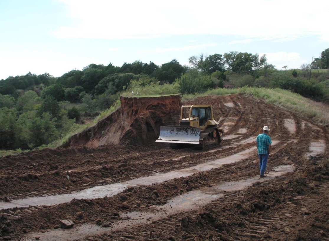
- Excavating a “notch” through the embankment as the reservoir level decreased to reduce storage and reduce downstream consequences in the event of a flood or uncontrolled dam breach.
The reservoir flood pool had completely receded by the end of August. During that time, the embankment was excavated down to a point slightly above the principal spillway crest elevation. The principal spillway riser was also modified to increase its capacity. These modifications were intended to reduce the risk of the impoundment storing a large amount of water while also still providing flood control for a relatively frequent 5-year flood event. The dam was kept in this interim state until permanent rehabilitation could take place.
Rehabilitation
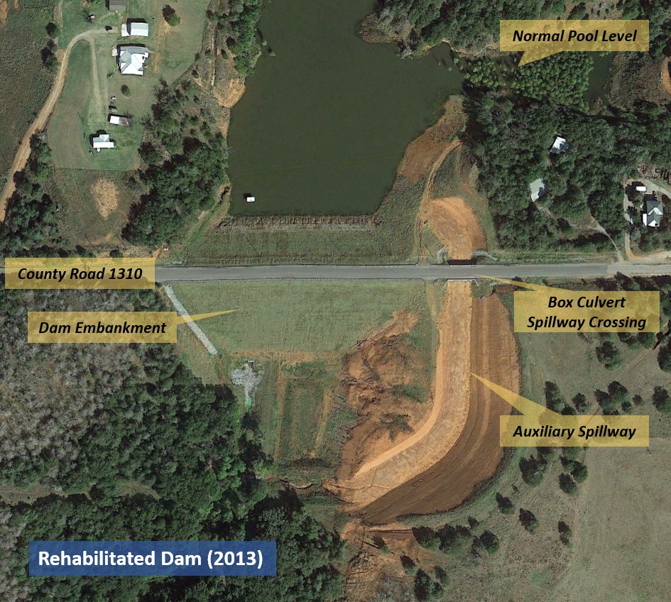
Beginning in 2011, the dam underwent a major rehabilitation which consisted of relocating the dam embankment downstream from its previous location, rerouting County Road 1310 over the top of the dam and constructing a new principal spillway. The project also included construction of a new auxiliary spillway on a modified alignment at the left abutment. The auxiliary spillway crest elevation was raised by 3.8 feet and a box culvert was incorporated into the design to allow County Road 1310 to traverse the spillway channel. Rehabilitation of the dam is estimated to provide $13 million in flood-reduction benefits over an anticipated 100-year life of the structure (NRCS, 2009).
For more information on the potential negative impacts of spillway outflows and other case studies similar to Sugar Creek Dam, check out this lesson learned.
References
This case study was peer-reviewed by Wade Anderson, P.E., U.S. Army Corps of Engineers.


Lessons Learned

All dams need an operable means of drawing down the reservoir.
Learn more
Dams should be thoroughly assessed for risk using a periodic risk review process including a site inspection, review of original design/construction/performance, and analysis of potential failure modes and consequences of failure.
Learn more
Downstream of constructed spillway exit channels, spillway outflows can erode and even breach dam embankments and can adversely impact the operation of outlet works.
Learn more
Dozens of dams can fail or be in danger of failing during a single event (i.e. swarming failures). Dam owners and regulators need to prepare for these types of events.
Learn more
Intervention can stop or minimize consequences of a dam failure. Warning signs should not be ignored.
Learn more
Many earth-cut spillways have been constructed in erodible material that can result in unsatisfactory performance and breaching of the spillway
Learn moreAdditional Lessons Learned (Not Yet Developed)
- Modifications to design during construction need to be assessed and understood. Changes to reduce cost or facilitate construction may unintentionally hinder safe operation and performance of a dam and its appurtenances.
- Changes downstream of a dam (e.g., culvert replacements, channel modifications, etc.) can impact tailwater conditions, impair spillway performance, and even contribute to failure. Downstream areas should be monitored for change, and if observed, the effect of changes on safe dam performance should be evaluated. Consideration should also be given to obtaining easements for downstream features that could impact dam performance.

A Dam Incident at Sugar Creek L44

A Successful Failure – Not Apollo 13, A Dam Incident at Sugar Creek Site L-44

Earthen/Vegetated Auxiliary Spillway Erosion Prediction for Dams

What Happens Downstream Stays Downstream, or Does It? Potential Failure Modes from Spillway Exit Flows