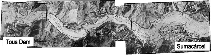
Tous Dam is located in the Province of Valencia in the southeast corner of Spain, near the Mediterranean Coast. The dam is the last flood control structure on the Júcar River Basin, an 8,340-square-mile drainage. The Júcar River Basin ranges dramatically between sea level and over 6,000 feet of elevation. The coastal influence combined with the rapid elevation rise creates a highly variable climate, with average annual precipitation ranging between 12 inches in the south to roughly 30 inches in the north. The climate in the Júcar River delta region is characterized as arid/semi-arid with dramatic precipitation fluctuations between prolonged droughts and torrential downpours. Extreme precipitation and flooding conditions are well documented dating back to the 16th century.
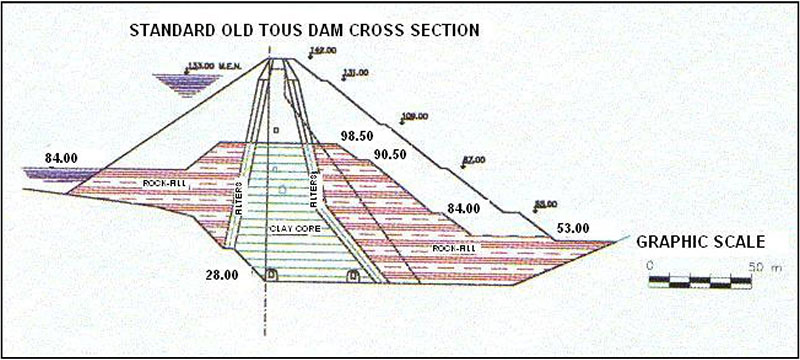
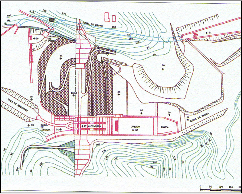
Construction of the original Tous Dam was first started in 1958 and was ultimately envisioned as a 465-foot-tall concrete dam. However, the discovery of two faults along the river bed forced engineers to stop the first phase of construction in 1964 and re-evaluate the design. The concrete abutments that had been constructed prior to termination of the original dam project were left in place and incorporated into the final design of the dam.Construction was resumed after a 10 year hiatus with a revised configuration consisting of a 230-foot-tall zoned embankment with a clay core and rockfill shells (D50 between 8 and 12 inches), sandwiched between the previously constructed concrete abutments. The peak spillway design capacity of 250,000 cfs roughly corresponded to a 500-year flood event when all three 50-foot-wide by 35-foot-tall radial gates were open. Construction of the first phase was completed in 1978. The second phase, envisioning a 235-foot raise of the existing dam, was never constructed.

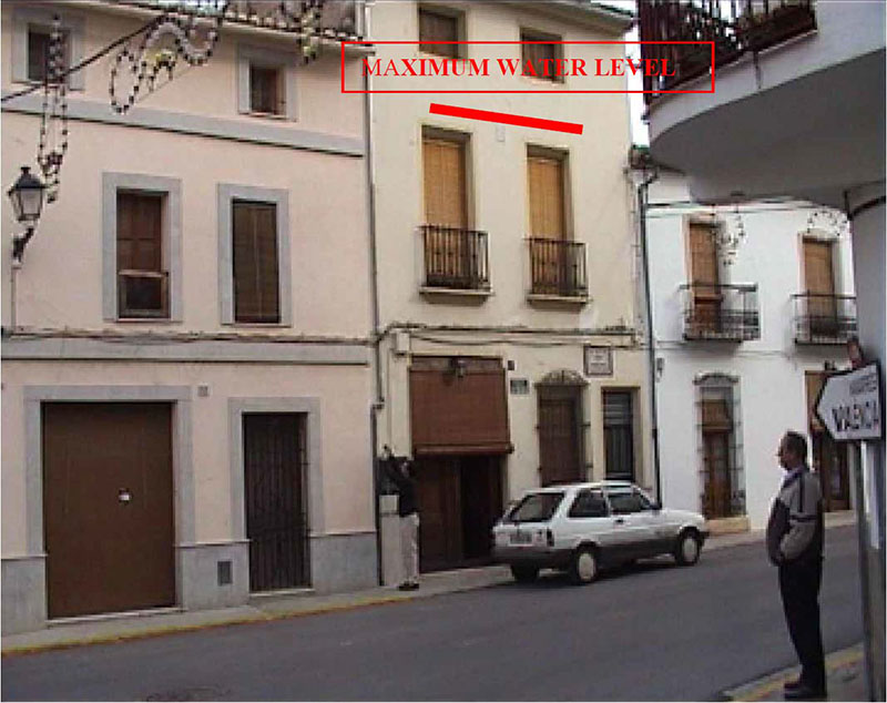
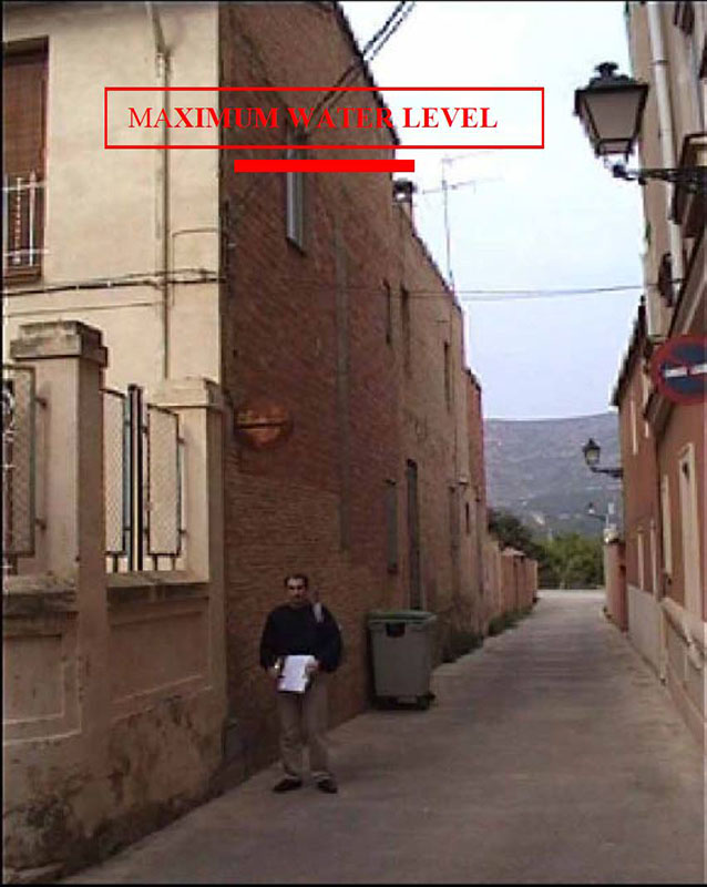
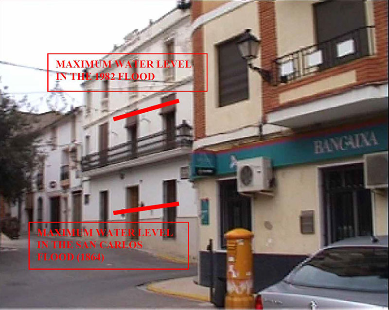
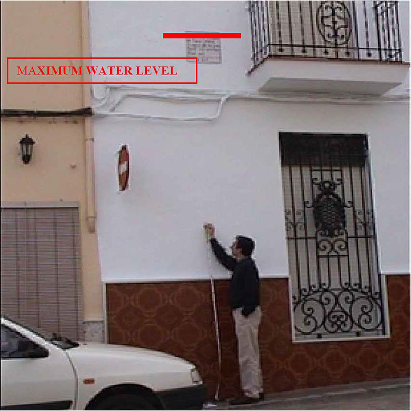
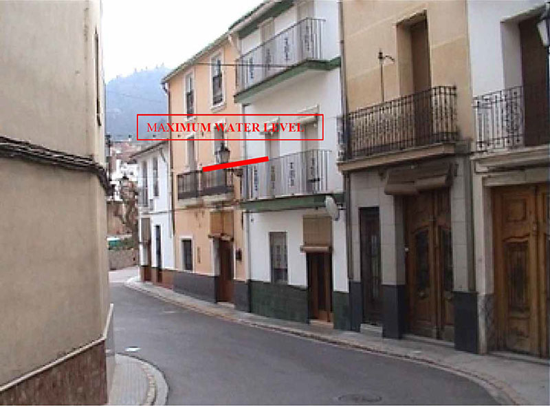
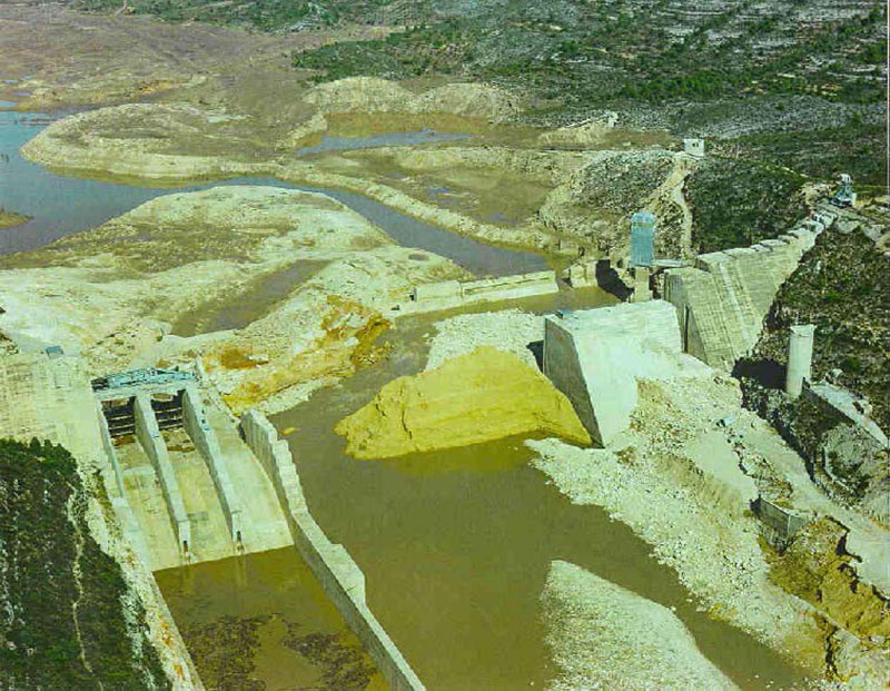
Tous Dam failed only 4 years after completion of the original construction in 1982, when an intense storm cell during a heavy rain event delivered 22 inches of precipitation, or about the equivalent of the average total annual rainfall, within a 24-hour period. Inflows to Tous Reservoir at the peak of the storm were estimated up to 350,000 cfs and caused the reservoir level to rise approximately 3 feet over the dam crest. While the overtopping and failure of the dam could largely be attributed to the inadequate spillway design capacity, additional adverse factors contributed to this overtopping failure. Power to the electrical grid was lost in the early stages of the storm, thereby rendering the spillway gates inoperable. According to reports and interviews conducted after the event, the only operable power generator available at the site was underwater before the engineer arrived at 9:00 am that morning. By that time, water was already pouring over the spillway gates and continuing to rise, though the reservoir level was still about 35 feet below the dam crest. The engineer alerted the authorities of the concerning situation and requested a replacement generator in order to operate the spillway gates, but the authorities did not heed the engineer’s warning to evacuate. Further complicating matters, access to the site for the emergency generator delivery vehicle was blocked by the flooding. Subsequent reports indicate that a backup generator didn’t arrive onsite until around 2:00 pm (4.5 hours after initially requested) and that it was too late by that time. The reservoir level rose to about 3 feet below the dam crest by 4:30 pm. Out of frustration with the inadequate response by the local government, the site engineer falsely reported that the dam had failed at 6:00 pm, which forced authorities to order an evacuation of the nearby community of Sumacárcel. The dam failure reportedly occurred shortly after 7:00 pm, when the reservoir overtopped the dam crest by approximately 3 feet and eroded the central embankment section of the dam. The reservoir level dropped about 60 feet by 11:30 pm that evening.
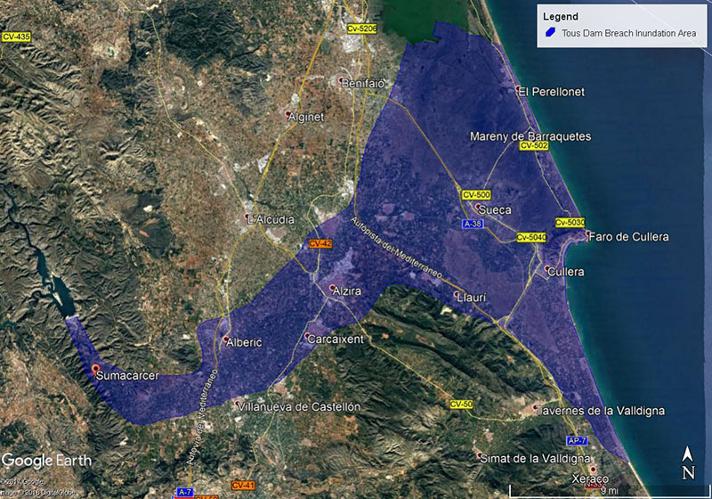
The overtopping dam failure led to a peak breach flow of 550,000 cfs; over 150 percent greater than the flood inflows and over 200 percent larger than the peak spillway design capacity. The dam failure led to devastating flooding, economic and environmental damage, evacuation of roughly 100,000 people, indirect consequential impacts to roughly 300,000 people, and 8 lost lives directly attributed to the dam failure.
Though the dam failure was an undeniably regrettable event, significant changes in dam safety standards, emergency communications and risk management were borne out of the experience that have and will continue to shape flood management policy and strategies in Spain and throughout the European Union. The Tous Dam failure was a catalyst in the development and adoption of the early stages of risk-based dam design, flood management policies, the development of systems to improve understanding of flood risks, the development of emergency action plans, and redundant/reliable communications systems for both flood and all-hazards emergency situations. In many ways, the Tous Dam failure had similar impacts on the Spanish and European emergency management community as the Teton Dam failure had on dam safety policy in the United States. In the second international Dam World Conference, Castillo-Rodriguez et. al. (2015) highlighted the Tous Dam Failure as a driving force behind policy changes in the Spanish dam safety community:
“The history of dam safety regulation in Spain has been influenced by two dam failure events: the failure of Ribadelago dam (Zamora, Spain) in 1959 and the failure of Tous dam (Valencia, Spain) in 1982. Both failures were landmark events in the national dam safety regulation framework.” - A. Serra-Llobet, J. Tabara, & D. Sauri, 2013
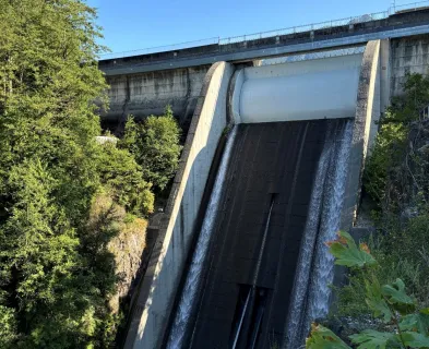
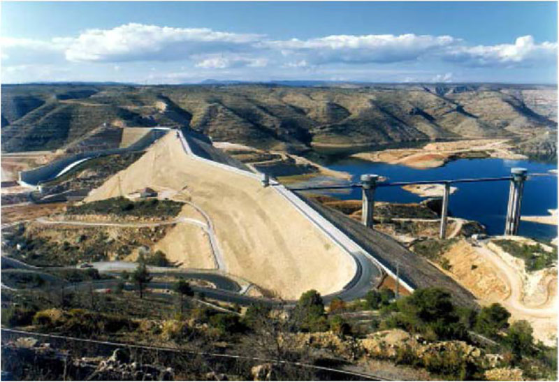
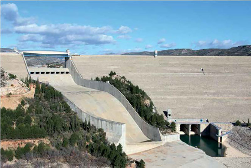
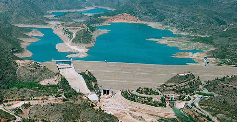
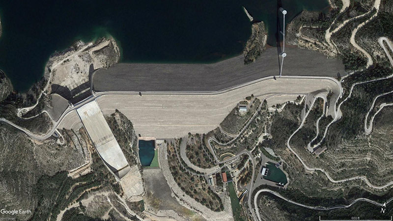
The dam was rebuilt in 1996 in the same location, but with significant modifications to address previous deficiencies. Some of these modifications include a uniform zoned earthfill embankment cross section across the entire dam length with no abrupt material changes, an increase in dam height to 360-feet providing a reservoir capacity increase of 4.7 times for additional flood capacity, and an ungated open channel spillway designed to safely route the full Probable Maximum Flood.
References:
(1) Alcrudo, A., & Mulet, J. (2007). Tous Dam is the last flood control structure of the Júcar River. Journal of Hydraulic Research, 45-57.
(2) Alcrudo, F. (2003). The Search for a Test Case. IMPACT Project. Louvain-La-Neuve, Belgium.
(3) Castillo-Rodriguez, J. T., Morales-Torres, A., & Escuder-Bueno, I. (2015). A Risk-Informed Journey Towards Improved Dam Safety Governance in Spain. Second International Dam World Conference. Lisbon, Portugal: National Laboratory of Civil Engineering (LNEC).
(4) Dragados. (2015, February 27). The Case of Tous Dam (Valencia, Spain). Rain Project.
(5) Iberia Nature. (2017, April 3). Retrieved from Mountains in Spain
(7) Marco, J. B. (1995). Hydrometeorological and Hydraulic Factors and Problmes Related to Floods in Arid Regions of Spain. US - Italy Research Workshop on the Hydrometeorolgy, Impacts and Management of Extreme Floods. Perugia, Italy.
(8) Serra-Llobet, A., Tabara, J., & Sauri, D. (2013). The Tous dam disaster of 1982 and the origins of integrated flood risk management in Spain. Natural Hazards, 1981-1998.
(9) Sharma, R., & Kumar, A. (2013). Case Histories of Earthen Dam Failures. International Conference on Case Histories in Geotechnical Engineering. Chicago.
This case study summary was peer-reviewed by Mark Baker, P.E., DamCrest Consulting.


Lessons Learned

All dams need an operable means of drawing down the reservoir.
Learn more
Emergency Action Plans can save lives and must be updated, understood, and practiced regularly to be effective.
Learn more
Extreme floods do occur.
Learn more
High and significant hazard dams should be designed to pass an appropriate design flood. Dams constructed prior to the availability of extreme rainfall data should be assessed to make sure they have adequate spillway capacity.
Learn more
Intervention can stop or minimize consequences of a dam failure. Warning signs should not be ignored.
Learn more
Regular operation, maintenance, and inspection of dams is important to the early detection and prevention of dam failure.
Learn more
Timely warning and rapid public response are critical to saving lives during a dam emergency.
Learn moreAdditional Lessons Learned (Not Yet Developed)
- Dams should be accessible at all times (especially during floods).
- Redundancy of power availability for mechanical equipment is of utmost importance.
- Dam owners and the dam engineering industry must develop strong working relationships with the emergency management community in advance of dam safety emergencies.