Contributor

Contributed By: Lee Mauney, P.E., CFM
Title: Dam Levee & Civil Works Project Manager
Organization: HDR
Email: [email protected]
Description & Background
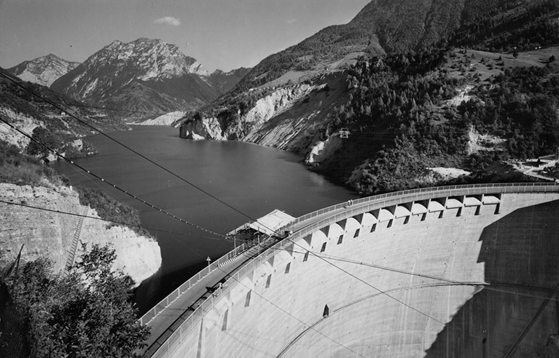
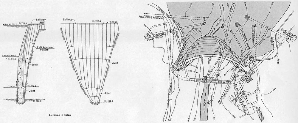
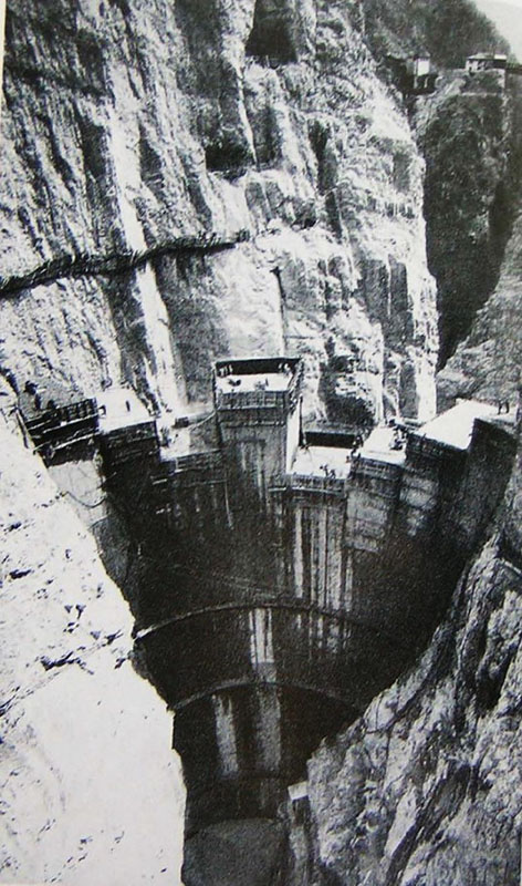
Vajont Dam is a double-curved, thin-arch dam, and at 860 feet high, it remains one of the tallest dams in the world. The dam is 11 feet wide at the crest, 73 feet wide at the base, with a crest length of 623 feet. There are 16 gates on the crest with an underground powerhouse and three outlets in the abutment. The reservoir capacity was designed for 138,000 acre-feet. Vajont was part of an extensive network of dams, powerhouses and tunnels constructed for hydro-electric power generation by the Società Adriatica di Elettricità (SADE). At the time of the incident, ownership had been transferred to ENEL, the national agency of electricity.
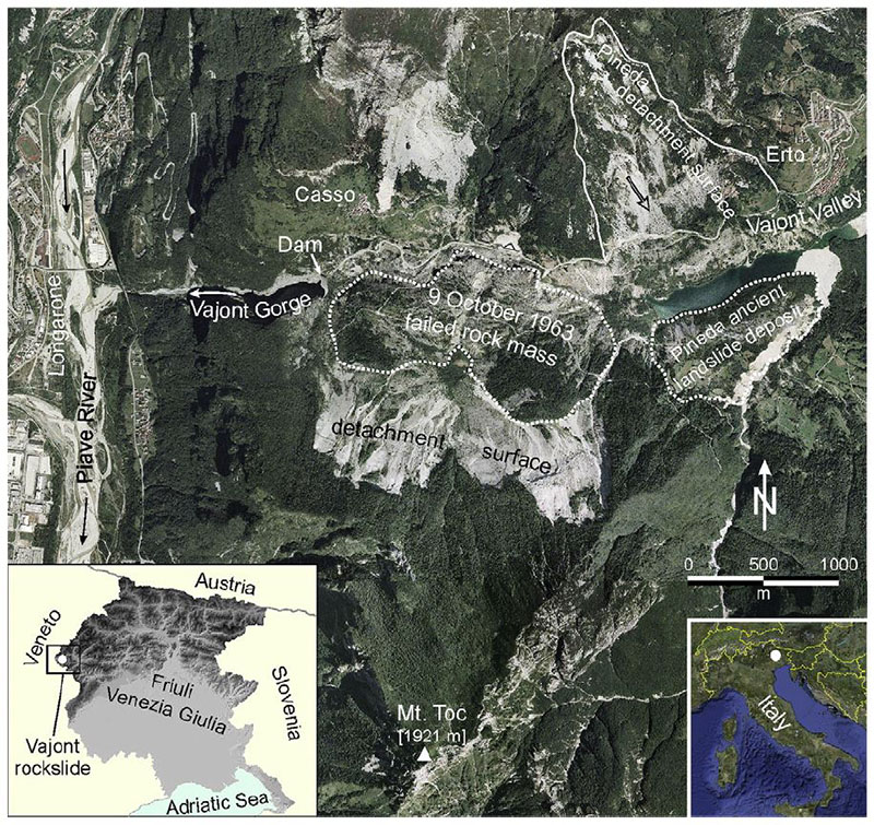
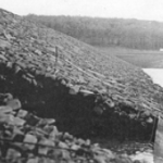
Imagery of Vajont Rockslide. (Photo Source: Paronuzzi and Bolla, 2012); Google Earth View: http://ow.ly/Uyxp30nzTss
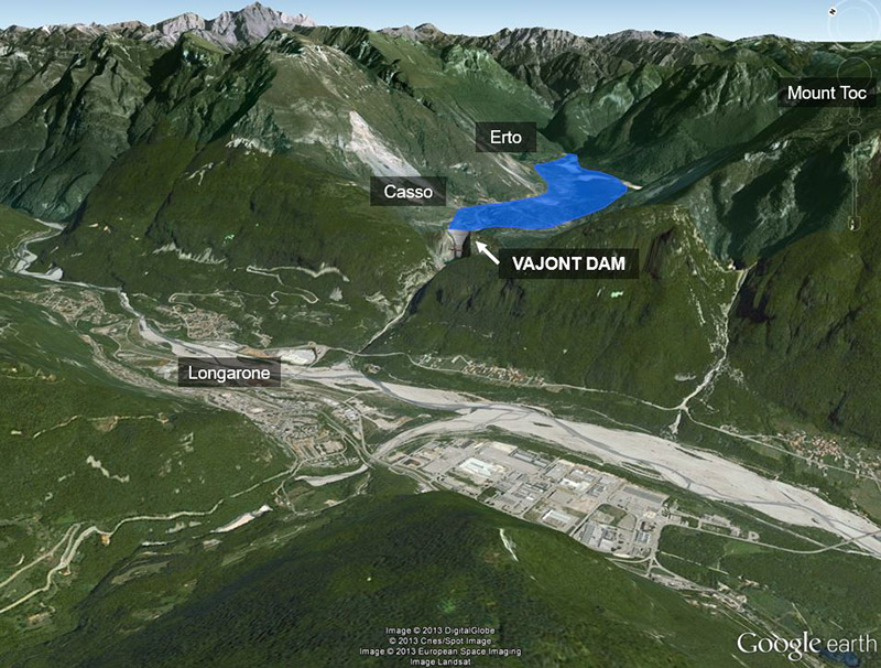
Vajont Dam is located on the Vajont River, a tributary of the Piave River, just upstream of Longarone in northeast Italy. Longarone is approximately 60 miles north of Venice, Italy. The dam was built in a steep and narrow limestone canyon, high in the Dolomite region of the Italian Alps, sculpted by downcutting and erosion of the river. Mountains in this area are characterized by nearly vertical cliffs. Mount Toc, located within the Vajont basin, towers 4,800 feet above the valley floor.
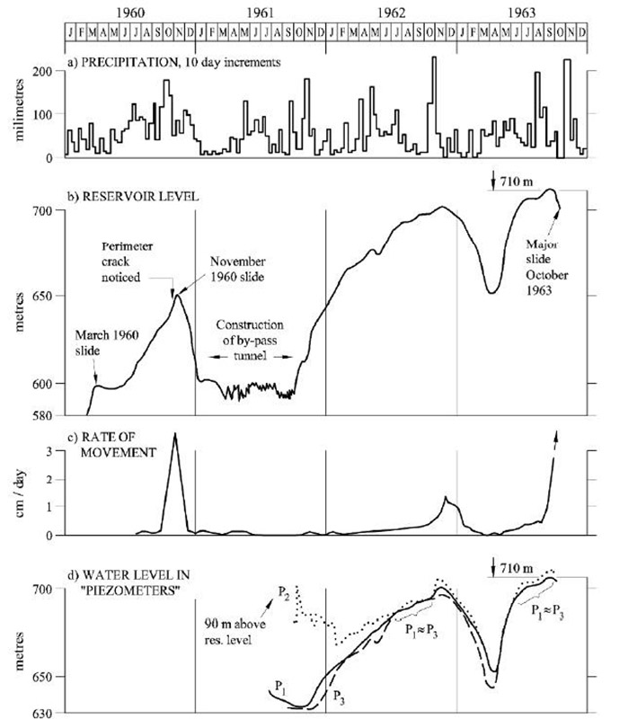
Construction began in July 1957, and the Vajont reservoir began filling in February 1960. During first filling there were differing opinions on whether the reservoir bank along Mount Toc was the site of an ancient rockslide. A local newspaper published an article suggesting that landslides were recurrent near the dam site and increased the likelihood of a disaster. This created a reaction with the public and shortly after, legal action was taken against the newspaper for spreading false news and disturbing the peace. Residents were assured of safety, but they continued to distrust the stability of Mount Toc, nicknaming it “the mountain that walks”. Dam construction was completed in September 1960.
The reservoir continued filling until November 4, 1960 when, with the reservoir water level at a depth 600 feet (elev. 645 meters), a rockslide of almost one million cubic yards entered the reservoir. A seven foot wave propagated across the reservoir as a result of the landslide, but there were no injuries. From November to December 1960, the reservoir was lowered to a depth of about 450 feet (elev. 600 meters). Following the slide, hydraulic models were performed, and exploration wells and piezometers were installed to monitor conditions. In October 1961, construction of a bypass tunnel was completed to connect the upper and lower reaches of the reservoir in case they were separated by another slide.
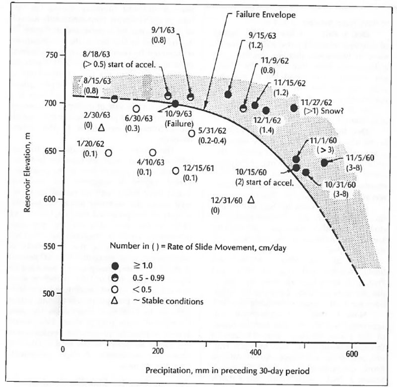
The reservoir was allowed to rise over the next year, until in November 1962, when a large precipitation event caused the lake level to reach a depth of 780 feet (elev. 700 meters). During this event, measured earth movements (creep) increased to 0.5 inches per day within the basin. The reservoir was again lowered from December 1962 to March 1963, causing the movements to cease. From April to July 1963 the reservoir was raised 16 feet (to elev. 705 meters), again causing movements to return to 0.2 inches per day. A pattern had emerged by this point – as the reservoir level increased, so did the measured creep.
During the summer of 1963, another precipitation event similar to the one experienced the previous year caused the water surface elevation of the reservoir to increase to the highest recorded level, 814 feet deep, 50 feet from the dam crest elevation (elev. 710 meters). Movements at this time were measured at over 1.2 inches per day, thus another reservoir drawdown was commenced. By October 4, total movement reached almost 8 inches per day.
Several days before the disaster, the mayor of Erto issued a manifesto urging villagers to evacuate. A few homes were evacuated, but there was little concern. The mayor of Casso ordered people to evacuate slopes and posted notice of an expected wave from an anticipated landslide. An hour and a half before the disaster, traffic was restrained on roads below the dam, while telephone messages said “maybe a little water over the dam tonight, (but).. nothing to be alarmed about.” The electric company was said to have told an engineer to “stay calm and sleep with his eyes open”.
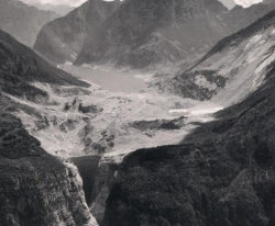
On the night of October 9, 1963, a massive rockslide occurred with the reservoir 782 feet deep (elev. 700.4 meters). At the time of slide, the reservoir level was 82 feet below the dam crest elevation and the reservoir volume was around 109,000 acre-feet. At approximately 1.2 miles wide by 1.0 mile deep, the enormous mass was estimated at 350 million cubic yards of earth and debris. The volume of the slide was about twice the volume of water impounded behind Vajont Dam and slid into the reservoir in less than 45 seconds.
Vajont is considered the most disastrous rockslide ever to occur in Europe. The event created strong earth tremors, recorded as far away as Vienna and Brussels. The rockslide displaced the Vajont reservoir, causing wind and water to travel in all directions. An updraft of air, rocks, and water climbed the canyon walls to around 850 feet above the reservoir. Waves of water reached greater than 330 feet above the dam crest. Approximately 20,000 acre-feet of water went over the dam, creating a flood depth at the mouth of Vajont River of about 230 feet, one mile downstream.
Warnings issued prior to the Vajont rockslide were largely ineffective. Officials thought the reservoir was drawn down enough to not cause harm, but they grossly underestimated the resultant size of the rockslide. Warnings were not issued in sufficient time for downstream residents to evacuate, and if they were, very few people heeded the warnings. The flood occurred at night when many downstream residents were in bed. Typically, dam failure events that occur at night are more fatal than events that happen during the day.
The consequences of this event are unique in scale, with extremely high fatality rates caused by very deep and fast-moving flood waters. Total fatalities were estimated at upwards of 2,056 and many more were injured. Residents who were able to evacuate escaped on foot, instinctively running uphill after hearing loud sounds. The wind created by the rapid displacement of air caused destruction before the water arrived. The full extent of damage was not obvious until early the next morning. There was very little chance of people being rescued. Most structures were either completely destroyed or buried.
There was extensive onsite monitoring at the dam when the rockslide occurred, with 20 technical personnel in the control center on the left abutment, all of whom perished. Forty people were killed in an office and hotel buildings near the right abutment, 300 feet above the reservoir level. A wave of water washed above the lake to Casso and Erto, communities above the reservoir, where the air blast and water destroyed buildings and caused at least 158 fatalities.
Five downstream towns were destroyed including Longarone, Pirago, Rivalta, Villanova, and Fae. The water first arrived in Longarone at 10:43 pm, around 4 minutes after the rockslide. The town was completely leveled due to the depth and speed of the flood wave (high severity flooding). Of an estimated 1,328 people in Longarone who were at risk at the time of the floodwave, 1,269 fatalities occurred, resulting in a fatality rate of 94 percent. Longarone was a tourist destination, a mountain village made up of mostly residential and commercial structures. The flood wave completely destroyed the town, resulting in one of the highest known fatality rates ever recorded due to flooding from a dam failure or incident.
Surprisingly, the Vajont Dam structure sustained little damage, even though subjected to a force from the combined slide and overtopping wave far in excess of design pressures. The dam remains in place today, albeit with no water behind it. Though the dam structure appears to have been well designed (only the top several feet of the dam suffered damage), designers didn’t understand the geology in the valley basin.
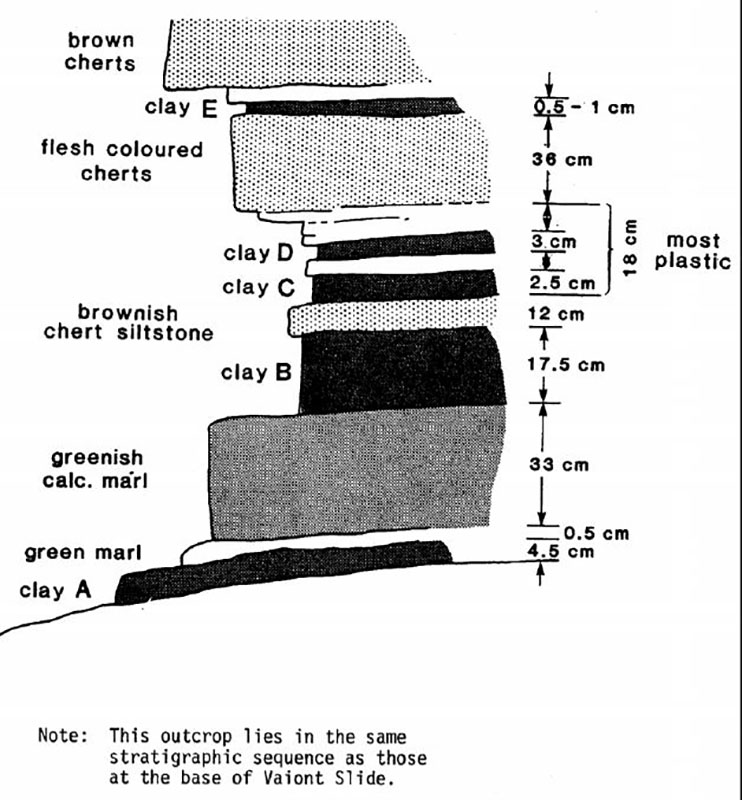
A slope stability failure occurs when the weight of a soil and rock mass overcomes the soil’s shear resistance along a failure plane. The Vajont slide occurred because of combined effects of a rising reservoir and heavy rainfall – water within the soil reducing shear strength – reactivating a historic failure surface. The slide mass moved as a block, slipping on one or more saturated clay layers, continuous throughout large areas in the basin. This fat clay layer acted as both a lubricant, reducing friction along the failure plane, and as a membrane to hold back water. Stability analyses were not conducted during dam construction or first filling, even after the appearance of the large slope instability in early November 1960. Vajont highlights the need for thorough geotechnical investigations during dam design, specifically reservoir slope stability analyses for dams in mountainous areas.
“Any damsite investigation should include a detailed study of the proposed reservoir slopes. If old slides or areas susceptible to sliding are identified, a detailed evaluation of their relative stability under reservoir conditions should be required. The lesson afforded by (Vajont) need not be relearned by another generation.” – Hendron and Patton, 1986
Officials did not recognize the magnitude of the danger or the scale of a possible rockslide at Vajont. Even those most familiar with the facility, including engineers who worked at the dam site did not seem to understand the risks. The October rockslide was over 400 times larger than the slide three years prior. It is common for people to revert to recent, observed history to try and predict the future, while normalizing observations. There can also be hesitation to warn and evacuate people before an outcome is certain. Even if officials and engineers understood the risk associated with a rockslide, there were few ways to remediate the situation after construction, outside of removing the Dam completely or evacuating and relocating towns downstream of Vajont.
This case study can remind us of the hazards that exist at dams, even if a structure is considered safe and does not fail. In the years before the incident, the risk of a major rockslide and its consequences were normalized and as the event was proceeding, a clear, concise warning message was never issued. Vajont highlights the need for thorough geotechnical investigations during dam design, specifically reservoir slope stability analyses. Vajont Dam remains in place today and provides a unique and important educational opportunity for visitors.
References:
(4) Hoek, E. (2007). Rock Engineering, The Development of Rock Engineering, Chapter 2.
(6) Muller, L. (1964). The rock slide in the Vajont Valley, Rock Mechanics and Engineering Geology, International Society for Rock Mechanics, Volume 2, p 148-212.
(7) Paolini & Vacis. (2000). The Story of Vajont. Translated from Italian, Bordighera Press.
(9) Paronuzzi, Rigo & Bolla. (2013). Influence of filling-drawdown cycles of the Vajont reservoir on Mt. Toc slope stability. Geomorphology Journal.
(10) Quarantelli, E.L. (1979). The Vaiont Dam Overflow: A Case Study of Extra-Community Responses in Massive Disasters, Disasters, Volume 3, No. 2, p 199-212, University of Delaware, Disaster Research Center.
(11) Semenza, E. (1966). Sintesi Degli Studi Geologici Sulla Frana Del Vajont, Meseo Tridentino Di Scienze Naturali, Trento.
This case study summary was peer-reviewed by Giorgia DeWolfe, Bureau of Reclamation.
Summary
Photos
-

- Vajont Dam, September 1963 (Reservoir elevation 710 meters, month prior to incident) (Photo Source: Wikimedia – VENET01 – CC BY_SA 4.0, Creative Commons License)
-

- Relationship between precipitation, reservoir elevation, maximum velocity of horizontal surface displacements, and water level in piezometers (Photo Source: Hendron and Patton, 1985)
-

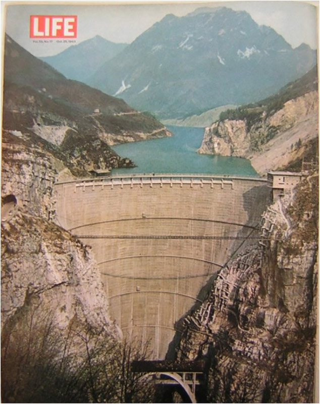
- Vajont Dam, Magazine Cover. (Photo Source: Life Magazine, 1963)
-
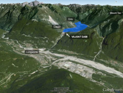
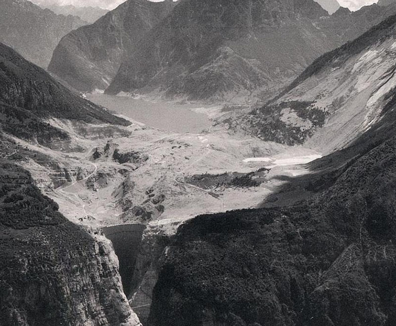
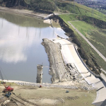
- Google Earth view of Vajont Dam (2013 imaging, reservoir drawn in and locations added) (Google Earth, Mauney, 2013)
-
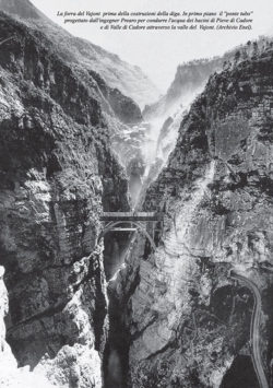
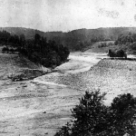
- Vajont gorge prior to dam construction with a bridge in the foreground. (Photo Source: ENEL Archive)

-

- Vajont Dam design drawings. (Photo Source: Dams of the World, Portland Cement Association)
-
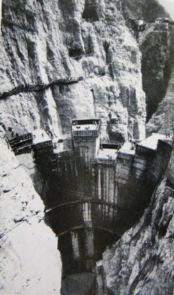
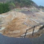
- Construction of Vajont Dam. (Photo Source: Dams of the World, Portland Cement Association)
-

- Sketch of outcrop that lies is same stratigraphic sequence as those at the base of the Vajont slide. (Photo Source: Genevois and Ghirotti, 2005, improved from Hendron and Patton, 1985)
-
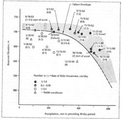
- The stability of the (Vajont) slide for reservoir elevation vs. 30-day precipitation (Photo Source: Hendron and Patton, 1985)
-

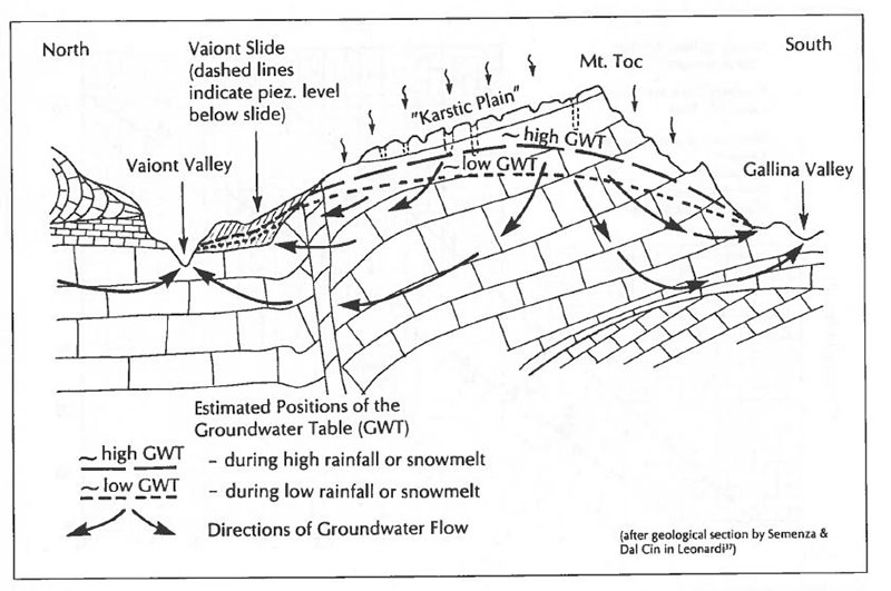
- A schematic section through the (Vajont) Slide showing the estimated regional groundwater flow system (Photo Source: Hendron and Patton, 1985)
-
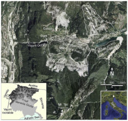
- Imagery of Vajont Rockslide. (Photo Source: Paronuzzi and Bolla, 2012)
-
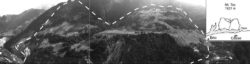
- The northern slope of Mount Toc seen from Casso (dashed line shows landslide mass area). (Genevois and Ghirotti, 2005)

-
- Vajont reservoir shortly after rockslide on October 9, 1963. (Photo Source: Semenza, 1966)
-

- After the deluge (Longarone, Italy). (Photo Source: Life Magazine, 1963)

Videos
-
- One of the Worst Man-Made Disasters in History – Smithsonian
-
- Vajont Dam – Disasters of the Century
-

- Towns Wiped Out in Night of Horror (News Reel, 1963)
-

- Strength Selection for Static Slope Stability Analysis – ASDSO Webinar
Lessons Learned

Dam failure sites offer an important opportunity for education and memorialization.
Dam incidents and failures can fundamentally be attributed to human factors.
Dams located in seismic areas should be evaluated for liquefaction, cracking, potential fault offsets, deformations, and settlement due to seismic loading.

Early Warning Systems can provide real-time information on the health of a dam, conditions during incidents, and advanced warning to evacuate ahead of dam failure flooding.

Emergency Action Plans can save lives and must be updated, understood, and practiced regularly to be effective.
Intervention can stop or minimize consequences of a dam failure. Warning signs should not be ignored.
Stability of the dam foundation and other geologic features must be considered during dam design.
The first filling of a reservoir should be planned, controlled, and monitored.

Timely warning and rapid public response are critical to saving lives during a dam emergency.
Additional Lessons Learned (Not Yet Developed)
- External independent peer review of designs and decisions is an effective means of providing quality assurance with design oversights and deficiencies.
- Geo-hazards can exist at dams, even if a structure is considered safe and does not fail.
- Thorough geotechnical investigations are needed during dam design, specifically reservoir slope stability analyses for dams in mountainous areas.
- A clear, concise warning message with specific details are more likely to be heeded during an emergency situation.
Other Resources

A Guide to Public Alerts and Warnings for Dam and Levee Emergencies
Author: D.S. Mileti & J.H. Sorensen
Prepared for the U.S. Army Corps of Engineers risk management center

Tragedy in the Italian Alps, 50th Anniversary, Vajont Dam
Author: L. Mauney & W. Graham
ASDSO Decade Dam Failure Series Presentation

Presentation: Landslides
Author: U.S. Army Corps of Engineer, U.S. Bureau of Reclamation, U.S. Department of Energy & Tennessee Valley Authority
Best Practices in Dam and Levee Safety Risk Analysis

Embankment Slope Instability
Author: U.S. Bureau of Reclamation & U.S. Army Corps of Engineers
Best Practices and Risk Methodology, Chapter IV-3

Landslide Risks
Author: U.S. Bureau of Reclamation & U.S. Army Corps of Engineers
Best Practices and Risk Methodology, Chapter VIII-2