Contributor

Contributed By: Lee Mauney, P.E., CFM
Title: Project Manager
Organization: HDR, Inc.
Email: [email protected]
Description & Background
What is an Early Warning System?
Most large dams or dams with high- or significant-hazard potential have at least some instrumentation to monitor dam performance and changes in behavior. Traditionally, dam instrumentation has required a person on-site to make readings and acquire data. Advances in technology and affordability now allow more efficient and effective fully automated collection and dissemination of monitoring data for dams of any size [1].
An Early Warning System (EWS) is an Automated Data-Acquisition System equipped to transmit and process data to include early warning notification features, and programmed to operate without the need of human intervention. An EWS may include various types of sensors, including reservoir/tailwater level monitoring, stream gauges, and weather measurements, however a successful EWS program encompasses much more than just instrumentation and offers numerous potential benefits for a dam/levee safety program.
Benefits of Early Warning
Emergency warning information is the single most important factor in getting people to take the best protective action in an emergency [2]. Remarkable gains in the prediction of pending natural disasters such as hurricanes, tsunamis, and tornados allow for advanced warning that undoubtedly saves lives across the world each year [3]. Weather prediction models continue to improve over time, providing better data and more accurate forecasts for decision makers and first responders. As it relates to dam and levee safety emergencies, timely warning and rapid public response have proven to be critical to reducing life loss. EWS allow owners and emergency response teams to provide advanced warning prior to flooding or to identify incidents that are developing at dams and levees. In addition, an EWS enables proactive steps to be taken during the development stage of a potential failure which may provide additional time to take action to reduce the probability of imminent failure.
Analyses and simulations of historic dam failures show that advanced warning time and prior evacuation before failure can have a fundamental influence on decreasing fatality rates for population at risk (PAR) located within inundation zones [4, 5, 6]. Examples of cases with limited, ineffective or no warning (Austin Dam, Canyon Lake, Malpasset Dam, South Fork Dam, Vajont Dam) can be compared with cases that demonstrate more adequate warning (Baldwin Hills, Castlewood Canyon, Teton Dam, Edenville Dam) to highlight the importance of warning times and rapid community response during dam failures.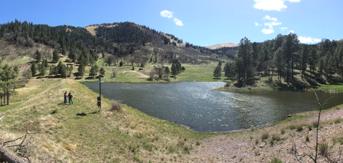
The detection of abnormal, hazardous and/or threatening conditions is the first step in issuing a more timely and effective warning. Early detection and evaluation of the conditions that initiate or require emergency response actions are crucial. Procedures for early notification are required to allow all entities involved with the Emergency Action Plan (EAP) implementation to respond appropriately. The key to reducing warning delay time is to quickly observe conditions, whether seismic, meteorological, structural, or other issues that signify a possible incident in progress. For a facility not continuously attended, an EWS can be installed to monitor conditions and promptly notify emergency management authorities of developing conditions [7, 8], and this incident-specific information can be critical to convincing the public that an incident is occurring and evacuation or response is necessary.
Reasons to Install an EWS at a Dam
Early warning of abnormal conditions or a potential dam safety incident is only one of many reasons to include an EWS at a dam. Other reasons include:
- A near real-time and continuous data record (replacing single point manual readings);
- More frequent and event-driven collection of data, capturing performance under varying loading conditions;
- Ability to analyze data remotely through web-based applications;
- Rapid processing and plotting of data, allowing easier and timelier evaluation and analysis;
- Ability to automatically initiate alarms to notify the appropriate staff when critical thresholds are exceeded;
- Better informed resource allocation of labor during regional, large-scale incidents that may impact multiple dams, and to support critical decision making;
- Rapidly changing phenomena can be measured;
- Continuous data even when the dam is inaccessible or limited by weather conditions (flooding, snow, storms, etc.); and
- Increased accuracy, reliability, and consistency through remote diagnostics and reduced human error from manual data inputs.
Risk Reduction and Cost Savings
An EWS can serve as a risk-reduction measure and provide cost savings to dam owners. Dams and levees are part of aging infrastructure that requires maintenance, and over time, rehabilitation and modifications are necessary [9]. Rehabilitation is often an expensive and lengthy process. Design and construction activities can be prioritized by risk analysis, with the most critical public and dam safety rehabilitation aspects addressed first. However, often budget constraints do not allow for the immediate remediation of all intolerable risk at or above guidelines. EWS installations can function as a non-structural risk mitigation measure until the structure can be improved to current standards [10].
Emergency management programs that effectively provide advanced warning of a change in dam behavior or conditions and evacuate the PAR prior to dam failure can lower risk in at least two key ways – by increasing the likelihood of successful intervention given initiation of a failure mode, and often most substantially, by lowering the fatality rates by increasing evacuation time. In certain cases, dam safety regulators may allow for consideration of an EWS during the inflow design flood selection process, thereby reducing spillway design capacity and construction requirements, providing substantial cost savings to dam owners [11]. EWS installations have become much more affordable and reliable during recent years, especially when considering long-term value and reduced labor costs. Maintenance and testing is still required to keep a system up and running effectively, yet cost is likely far less than continuing to have an operator conduct frequent manual readings.
Relationship to Visual Monitoring
An EWS can supplement routine visual inspections, but never replace them. Visual surveillance is one of the most important components of a dam safety program. Thorough visual 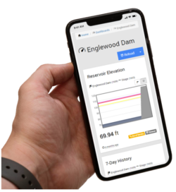 inspection by staff who are knowledgeable about a dam’s vulnerabilities and potential failure modes can provide insight and warning of unexpected performance that may not be captured from with instrumentation readings. The EWS instrumentation often collects data from point measurements so cannot provide a complete picture of a dam’s behavior. For example, an EWS may not necessarily identify the occurrence of seepage at a new location along a section of embankment that is not instrumented. When designing, reviewing, or auditing an EWS, there should be a clear understanding of what potential failure mode components that instrumentation is monitoring for, as well as the components not being monitored through instrumentation. Visual monitoring is the complimentary approach to address this missing monitoring component (as well as an essential practice for general project health). Normally EAP responses should not be initiated prior to visual confirmation.
Instruments often supply measurements that may evade visual surveillance such as pressures and flow. By providing data that supplements visual surveillance, a clearer understanding of dam performance is possible. An EWS produces this data and a long-term, quantitative record, which may provide insight into time-or load-depended trends in a dam’s performance. The ability to detect a change over time is important because these changes may be indicative of a developing potential failure mode [1].
When can an EWS be useful?
An EWS can be useful for a variety of monitoring needs during the life of a dam, including:
- During construction;
- First reservoir filling;
- Normal operations;
- During times of high releases;
- Abnormal loadings or incident/failure scenarios; and
- Support of legal and research needs [12].
An EWS can be beneficial on both dams and levee systems. The consequences of levee failures can be just as catastrophic as dam failures, so although monitoring levees present additional challenges largely related to their areal extent and intermittent loadings, they can often be monitored effectively [13].
EWS are especially valuable in situations when visual surveillance is not possible, for remote locations with access challenges, or during times when visual inspections are irregular (e.g. nights, weekends, harsh winters, and during storm events when visibility is low). An EWS can be programmed to capture and transmit data more frequently during flood events, as well as record data at regular intervals during normal conditions. Generally, automated instrumentation should receive consideration during new dam construction, major rehabilitations, or structural modifications [14].
The Future of EWS
Improved dam safety programs have helped reduce the number and impact of major dam failures, but work remains. From 2005 to 2019, state dam safety programs reported 296 dam failures. Future dam safety improvements will include non-structural measures, including continued deployment of Early Warning Systems [15]. Aging of existing dams is a universal issue that will become more challenging with time. With society’s growing concern about the safety of structures and increasing populations at risk in inundation zones, it is logical to expect that regulatory agencies will require more automatic monitoring of dams in the future [16].
Additional Best Practices
Top Ten Best Practices for EWS Design and Implementation
- Remember that an effective EWS is not simply a collection of instruments.
- Decide what needs to be measured.
- Keep it as simple as possible, but not simpler.
- Hire a professional.
- Design with telemetry and power supply in mind.
- Design with maintenance, safety, and accessibility in mind.
- Design for robustness and redundancy to make the system highly reliable.
- Make the data useful and intuitive.
- Ensure proper notifications and alarms.
- Take advantage of the latest technology.
References:
(1) Rubertis, K. (2018). Monitoring Dam Performance: Instrumentation and Measurements, American Society of Civil Engineers (ASCE), Manuals and Reports on Engineering Practice No. 135. Task Committee to Revise Guidelines for Dam Instrumentation.
(3) Silver, N. (2012). The Signal and the Noise: Why So Many Predictions Fail-but Some Don't. Penguin Press.
(5) Graham, W.J. (1999). A Procedure for Estimating Loss of Life Caused by Dam Failure (DSO-99-06). United States Department of the Interior, Bureau of Reclamation, Dam Safety Office.
(6) USACE. (2020). HEC-LifeSim Life Loss Estimation. US Army Corps of Engineers, Hydrologic Engineering Center.
(9) ASCE (2017). America’s Infrastructure Report Card. American Society of Civil Engineers. (Updated for 2021)
(11) Colorado Dam Safety Branch. (2020). Guidelines for Hydrologic Hazard Analysis. State of Colorado, Division of Water Resources, Department of Natural Resources, Dam Safety Branch. Section 2.11.
(15) ICOLD. (2020). Challenges and Needs for the Dams in the 21st Century, Bulletin 185. International Commission on Large Dams, Preprint Edition.
(16) ICOLD. (2000). Automated Dam Monitoring Systems: Guidelines and case histories, Bulletin 118. International Commission on Large Dams.
(17) Dunnicliff, J. (1988). Geotechnical Instrumentation for Monitoring Field Performance, John Wiley & Sons, Inc., New York.
(18) ICOLD. (2018). Dam Surveillance Guide, Bulletin 158. International Commission on Large Dams.
(20) Reclamation. (2001). Reclamation’s Design Process of Early Warning Systems for Dam Safety. Bureau of Reclamation, Water Operation and Maintenance Bulletin, p.19-23. David B. Fisher.
(21) BIA. (2014). Safety of Dams Program Handbook. Dam Safety, Security, and Emergency Management, 55 IAM-H. U.S. Department of the Interior, Bureau of Indian Affairs.
This lesson learned summary was peer-reviewed by Bill Johnstone, Spatial Vision Group; Jackie Blumberg, Korey Kadrmas, and Bill McCormick, Colorado DWR; Dan Klein, FERC; Dusty Myers, Eagle Creek Renewable Energy; Alon Dominitz, NY Dam Safety; and Mike Hand, WYOH2OPE.
Summary
Photos
-
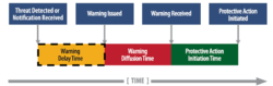
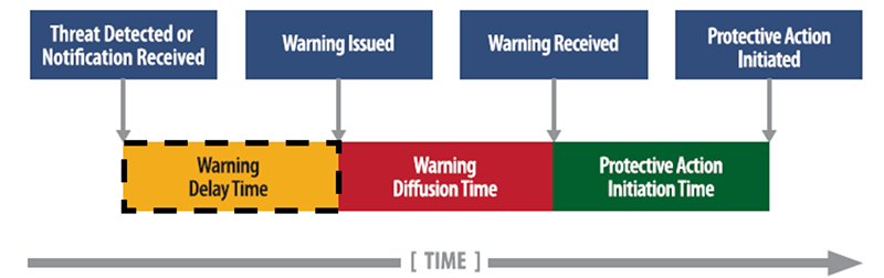
- Warning and Protective Action Initiation Timeline (modified from USACE [2]). ‘Warning delay time’ is the period between when a threat is first detected and when the first alert or warning is issued. An EWS can help to reduce the warning delay time.
-
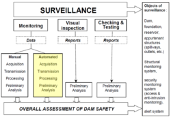
- Highlighted portion shows how automated monitoring fits within the overall dam surveillance framework (modified from ICOLD [16]).

-
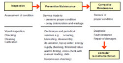
- Maintenance cycle of dam monitoring devices [18].
-
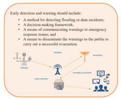
- Early detection and warning are key components of an emergency management program (modified from Reclamation [20]).

-

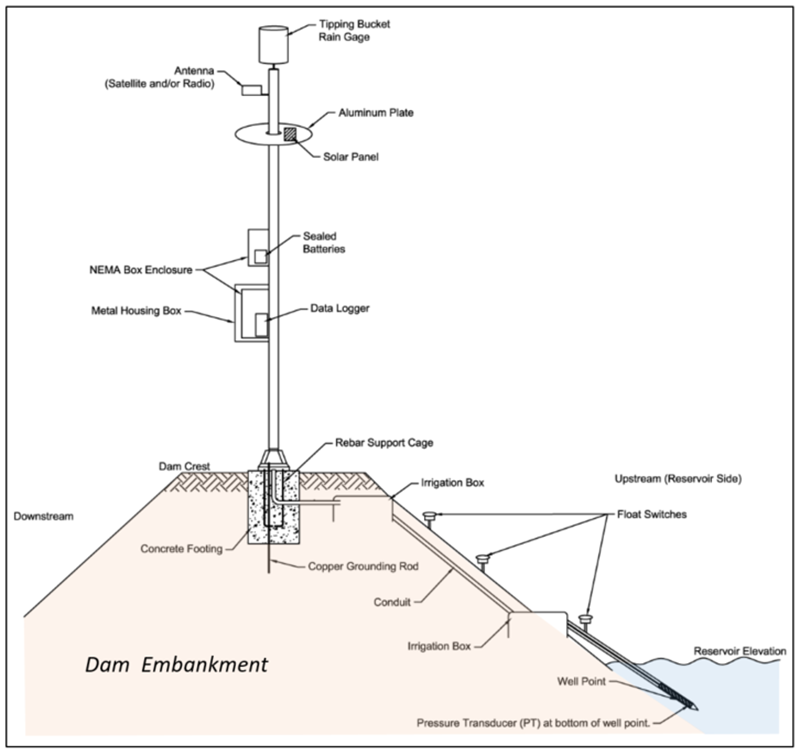
- Example schematic of a typical EWS installation on an embankment dam (modified from BIA [21]).
-

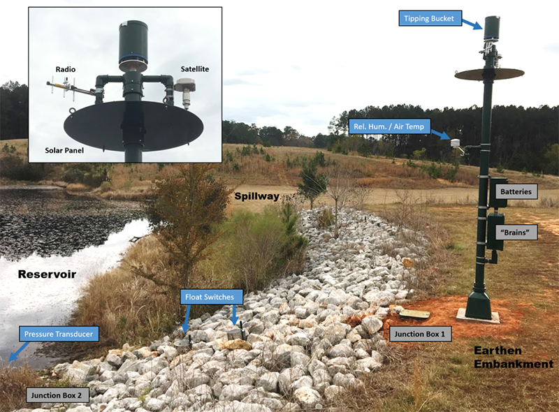
- Example of an EWS installation on an earthen embankment (Photo Credit: Mauney).
-

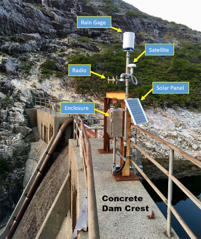
- Example of an EWS installation on a concrete dam (Mauney).
-
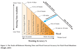
- The Trade-off between warning time and flood forecast accuracy (Photo Credit: Wright, 2001).

-

- False Alarm Myth [2]

-

- One Magic Technology Myth [2]

Videos
-

- PrepTalks, Modernizing Public Warning Messaging (Mileti, 2018)
-

- How to Make Your Emergency Action Plan More Effective – ASDSO Webinar
-
- Using Instrumentation for Dam Safety Monitoring – ASDSO Webinar
Case Studies
Austin (Bayless) Dam (Pennsylvania, 1911)
Austin Dam (also known as Bayless Dam) was constructed between May and November of 1909 just outside Austin, Pennsylvania, a town of approximately 2,500 people in Potter County.
Baldwin Hills Dam (California, 1963)
The Baldwin Hills Reservoir was constructed in 1951 to provide water to the south and southwest portions of the city of Los Angeles, California. Sitting atop one of the tallest hills in the region, the reservoir was confined on three sides by compacted earth dikes...

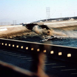
Canyon Lake Dam (South Dakota, 1972)
The Friday afternoon of June 9, 1972 was the beginning of a tragedy for Rapid City, South Dakota along the eastern slopes of the Black Hills mountain range. Scattered showers from the previous days had left the ground saturated while a low-level air mass...

Castlewood Canyon Dam (Colorado, 1933)
Castlewood Canyon Dam was constructed in 1890 across Cherry Creek, 40 miles southeast of Denver, Colorado. The masonry and rock-fill structure, built from local materials, was around 600 feet long with a height of 70 feet measured...
Malpasset Dam (France, 1959)
Malpasset Dam was a concrete arch dam located on the Riveria in the Cannes District near Fréjus, in Southern France. Exhibiting curvature in both the plan and section directions, the double-curvature arch structure spanned the Reyran River. At the time of completion in 1954, it was reported...

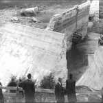
South Fork Dam (Pennsylvania, 1889)
South Fork Dam was an earth- and rock-fill dam located about 8 miles east of Johnstown, PA. Originally constructed in 1852, the dam’s primary purpose was to provide a source of water for a division of the Pennsylvania Canal. The dam was approximately 72 feet high...

Swift and Two Medicine Dams (Montana, 1964)
The second week of June 1964 brought one of the worst natural disasters in Montana’s recorded history. In all, the flooding caused 30 deaths, upwards of $60M in damages...
Teton Dam (Idaho, 1976)
Teton Dam was located in southeastern Idaho about 15 miles from Rexburg in the valley of the Teton River. The dam and its reservoir were the principal elements of the Teton Basin Project designed by the Bureau of Reclamation to control flooding as well as provide a source of...

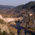
Vajont Dam (Italy, 1963)
Vajont Dam is a double-curved, thin-arch dam, and at 860 feet high, it remains one of the tallest dams in the world. The dam is 11 feet wide at the crest, 73 feet wide at the base, with a crest length of 623 feet. There are 16 gates on the crest with an underground powerhouse...

Williamsburg Reservoir Dam (Massachusetts, 1874)
The Mill River in western Massachusetts typified the New England hydrologic resources used by 19th century industry, and the valley development was like that along hundreds of other rivers around New England. The river is a tributary of New England’s largest river, the Connecticut...
Best Practices

Federal Guidelines for Dam Safety: Emergency Action Planning for Dams
Author: Federal Emergency Management Agency
Date Published: 2013

A Guide to Public Alerts and Warnings for Dam and Levee Emergencies
Author: USACE Risk Management Center
Date Published: 2015
Other Resources

EWS State Survey
Author: ASDSO

BIA Newsletter - Issue 02
Author: BIA Safety of Dams

BIA Newsletter - Issue 03
Author: BIA Safety of Dams


MHDF (Colorado) – Flood Warning Program Website
Author: Mile High Flood District
Alert System real-time data pages
NWS River Forecast Centers
Author: National Weather Service
Advanced Hydrological Prediction Service

U.S. Tsunami Warning System
Author: NOAA / National Weather Service

Flood Warning Systems Manual
Author: NOAA’s National Weather Service

Pacific Northwest Seismic Network
Author: Pacific Northwest Seismic Network
Earthquake Monitoring Network

Sacramento County Alert System (California)
Author: Sacramento Co.
Sacramento County Rainfall and Stream Level Information System

Arizona Flood Warning System (AFWS)
Author: Statewide collaboration between local, state and federal entities

USGS WaterWatch
Author: United States Geological Survey