Contributor

Contributed By: Everett W. Taylor, P.E.
Title: Dam Safety Engineer
Organization: Utah Dam Safety
Email: [email protected]
Description & Background
Flooding can trigger significant events for dam owners and operators. The events may range from needing to pass large flows to overtopping and possible failure of the dam. Consequently, dam owners are tasked with monitoring weather patterns and runoff to effectively operate their facilities during hydrologic events. Unusual or changing conditions in the watershed, however, may result in larger than expected runoff events that can surprise owners and operators. These conditions may include rain on snow events, frozen or saturated ground, burned watersheds, and more. While this summary primarily addresses naturally-occurring conditions that could impact the severity and magnitude of flooding, human activity within a watershed (e.g. development, deforestation) can have a similar effect. In addition to tracking weather and runoff predictions, dam owners and operators should be aware of the conditions in their contributing watersheds and consider the effects those conditions may have on runoff to their dams and reservoirs.
Rain-on-Snow
Rainfall and snowmelt contribute to runoff simultaneously during a rain-on-snow event and distinguishing the two can be difficult. It is estimated that the contribution from snowmelt during this type of event can range from 4 to 75 percent.
One example of this occurred on February 5, 1996 when rain began to fall on the Willamette River Basin, a drainage area of approximately 11,600 square miles. Continuous precipitation and below freezing temperatures during the month of January had left the surrounding mountains with snow packs approaching 173 percent of normal. On February 3rd and 4th, an ice storm left ice on an already saturated valley floor. Then on February 5th, temperatures warmed to nearly 60°F (15.5°C) accompanied by rainfall with daily precipitation totals ranging from 1 to 8 inches (25 to 200mm) over the next four days. The resultant rain-on-snow event triggered flooding along the Willamette River and in the Portland Harbor. Flood stage at the Portland Harbor is 18 feet (5.5m). The peak stage at the Portland Harbor during the event was 28.6 feet (8.7m) with an estimated peak flow of 1,000,000 cubic feet per second (28,300m3/s). By the end of the flood, snow at mid-level elevations in the Willamette Valley had melted off completely and significant melting had occurred at higher elevations. Federal, state, and private agencies coordinated operation of their respective dams and the community took other emergency actions to limit the damage from the flooding. It’s estimated that the coordinated effort prevented flood damages of $1.1 billion in Portland, Oregon.
Frozen or Saturated Ground
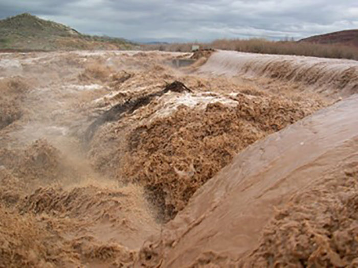
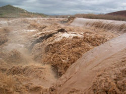
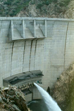
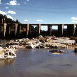
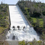
Water flowing over the Washington Diversion Dam, January 10, 2005.
Frozen ground may also increase runoff from rainfall events by preventing water infiltration into basin soils. Results of a study by the USGS at Sleepers River, Vermont indicate that rainfall events on frozen soils have a larger and somewhat quicker response compared to a no-frost condition. This is more prevalent when rain falls on bare frozen ground rather than forested areas. Additionally, saturated soils minimize infiltration during rainfall events and lead to increased runoff.
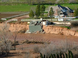
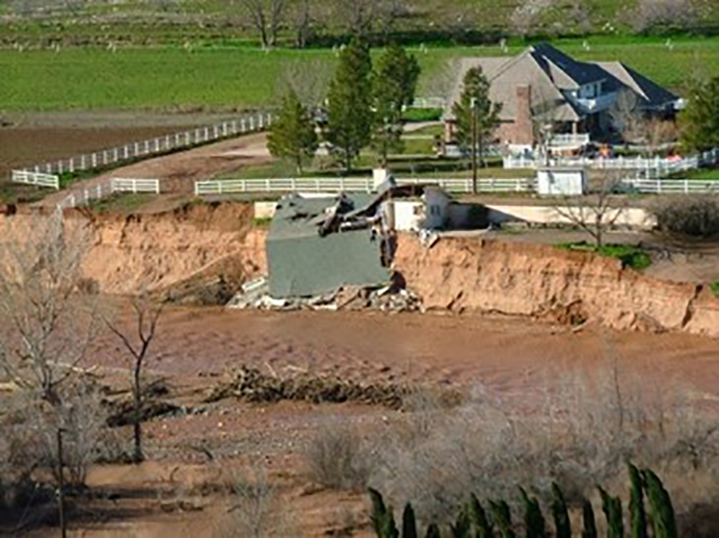
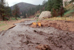
The above conditions were observed as multiple large storms moved through southwestern Utah in late 2004 and early 2005. In October 2004, soil moisture in southwestern Utah was estimated at 30 percent saturation. In mid-October a storm system from the Pacific Ocean moved into the area delivering 1.5 to 9.4 inches (38 to 240mm) of rainfall to the Virgin River basin above the confluence of the Santa Clara River. The total volume of water delivered by the storm system was estimated at 493,000 acre-feet (608 million cubic meters). The resultant peak discharge on the Virgin River was approximated at 11,000 cubic feet per second (310m3/s), corresponding to a 5- to 10-year recurrence interval.
In January 2005, another large storm system from the Pacific moved into the area. Soil moisture at this time was estimated at 70 percent saturation, an increase due largely to the storm in mid-October. Between January 8 and 12, 0.7 to 7.7 inches (18 to 200mm) of rain fell. The volume of this storm was estimated at 264,000 acre-feet (326 million cubic meters), a little more than half of what fell in the earlier October storm. However, due to the saturated and possibly frozen ground, the peak flow on the Virgin River was 19,000 cubic feet per second (540m3/s), a 73 percent increase over the peak flow caused by the October storm event. While only minor damage was reported after the October event, the January storm and resultant flood destroyed 28 homes and caused an estimated $85 million in property damage. Another $140 million was reported in damage to local infrastructure. During this event, several reservoirs reached capacity and began discharging through spillways. In one instance a masonry dam was overtopped when outflows exceeded spillway capacity. Fortunately, the dam did not fail during the overtopping event.
Wildland Fires
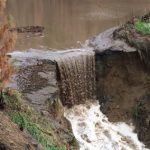
In addition to rain-on-snow events and frozen or saturated ground, watersheds that have been burned by wildland fires also produce increased runoff. Fire can destroy all or portions of the organic surface cover of a watershed and alter the infiltration capacity of the underlying soil. In some cases, soils that have been subject to fire can become almost water repellant. These changes affect the hydrologic soil conditions of the watershed, and lead to increased runoff potential. There is an increased susceptibility to flash floods on burned watersheds, with higher peak flows and shortened times to peak. This increased runoff can create substantial floods in channels downstream from burned watersheds.

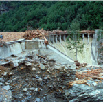
Water being released from Strontia Springs Dam after Buffalo Creek wildfire-related flooding. (Photo Source: John A. Moody, USGS)
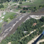
Buffalo Creek, Colorado is a small town located in the mountains southwest of Denver, adjacent to Buffalo Creek. In May 1996, an unattended campfire near Wellington Lake started what came to be known as the Buffalo Creek Fire. The fire led to the evacuations of two towns, Buffalo Creek and nearby Spring Creek. The fire burned an area two miles wide and 11 miles long (3.2km wide by 17.7km long). Because it had burned so hot, even ponderosa pines which can often survive low burning ground fires were killed by the fire. It was estimated that 63 percent of the burn area had experienced a high intensity, stand-replacing fire. Then, on July 12th of the same year, an intense thunderstorm dropped an estimated 2.5 inches (64mm) of rain in two hours. With approximately 25 percent of the Buffalo Creek and 75 percent of the Spring Creek watersheds burned, there was little left to protect the mountain slopes. Flood waters, laden with sediment and debris, rushed down Buffalo Creek and Spring Creek until they reached the South Platte River. It is reported that the river level experienced a rise of 10 feet (3m) from the flood. The town of Buffalo Creek suffered extensive damage and two residents were killed during the flooding. The flood deposited sediment and debris into Strontia Springs Reservoir reducing its storage capacity and created water quality and supply issues in other downstream reservoirs that provide municipal water to the Denver area. An estimated $35 million in damages were caused by the fire and subsequent flood.
Conclusion
Flooding events can cause serious concern and issues for dam owners and operators. To minimize their concern, many owners and operators monitor weather and runoff predictions. Unusual or changing circumstances in the watershed such as rain-on-snow events, frozen or saturated soils, or burn areas caused by wildland fires can exacerbate runoff and flooding potential. Consequently, dam owners should not only consider weather and runoff forecasts but should be aware of special or unusual conditions that exist in their watersheds and the possible effects that those conditions may have on runoff to their downstream dams and reservoirs.
References:
(1) Willingham, W.F. (2021) Willamette River Flood of 1996. Oregon Encyclopedia. 1/8/2021.
(2) Henriksen, C.A. (1997). 1996 Willamette and Columbia River Flood. Twenty years later – What we have learned since the Big Thompson Flood: Proceedings of a meeting held in Fort Collins, Colorado, July 13-15, 1996. Fort Collins, Colorado: Natural Hazard Center Collection.
(3) McCabe, G.J.; Clark, M.P. and Hay, L.E. (2007). Rain-on-snow Events in the Western United States.
(4) Li et al. (2019). The Role of Rain-On-Snow in Flooding Over the Conterminous United States.
(5) Wilkowske, C.D.; Kenney, T.A. and McKinney, T.S.. (2006). Flooding and Streamflow in Utah During Water Year 2005. United States Geological Survey.
(6) Shanley, J.B. and Chalmers, A. (1999). The Effect of Frozen Soil on Snowmelt Runoff at Sleepers River, Vermont. United States Geological Survey.
(7) Niu, G.Y. and Yang, Z.L. (2006). Effects of Frozen Soil on Snowmelt Runoff and Soil Water Storage at a Continental Scale.
(8) Gould et al. (2016). The Effects of Climate Change and Extreme Wildfire Events on Runoff Erosion over a Mountain Watershed.
(9) Neary, D.G.; Gottfried, G.J. and Ffolliott, P.F. (2003). Post-Wildfire Watershed Flood Responses.
(10) Robichaud, P.R.; Beyers, J.L. and Neary, D.G. (2000). Evaluating the Effectiveness of Postfire Rehabilitation Treatments.
(11) Moody, J.A. and Ebel, B.A. (2013). Infiltration and Runoff Generation Processes in Fire-Affected Soils.
(13) Dodd, B. (2013). Double Disaster at Buffalo Creek: The 1996 Fire and Flood.
This lesson learned was peer-reviewed by Gregory Richards, P.E., Gannett Fleming, Inc.
Summary
Photos
-
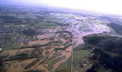
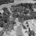
- An aerial view of the Willamette River’s flood. (Photo Source: Wikiwand – Willamette Valley flood of 1996)

-
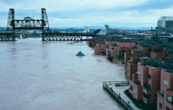
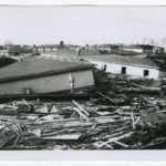
- Flooding just north of downtown Portland in February 1996, viewed looking southeast towards the Steel Bridge. (Photo Source: Wikiwand – Willamette Valley flood of 1996)

-
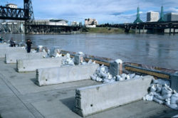
- Temporary barriers and sandbags holding plywood panels in place at the seawall in downtown Portland. (Photo Source: Wikiwand – Willamette Valley flood of 1996)

-
-
Water flowing over the Washington Diversion Dam, January 10, 2005.
(Photo Source: Karl Rasmussen, utahweather.org)

-
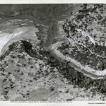
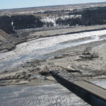
- Flooding along the Santa Clara River in southwestern Utah, January 12, 2005. (Photo Source: Russell D. Bangerter, utahweather.org)
-
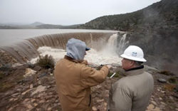
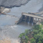
- Engineers discuss the overtopping of Lower Enterprise dam in December 2010. Improvements to the dam were made after the January 2005 overtopping event caused by regional flooding. (Photo Source: Jud Burkett, The Spectrum)

-
- Water being released from Strontia Springs Dam after Buffalo Creek wildfire-related flooding. (Photo Source: John A. Moody, USGS)
-
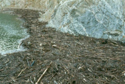
- Organic debris and sediment were deposited in Strontia Springs Reservoir, which supplies drinking water to the cities of Denver and Aurora. This debris came from two watersheds (Buffalo Creek and Spring Creek) burned by the 1996 Buffalo Creek Fire. Associated with this debris was an increase in manganese, which increased the chlorine demand of water treated for municipal usage. (Photo Source: John A. Moody, USGS)

-
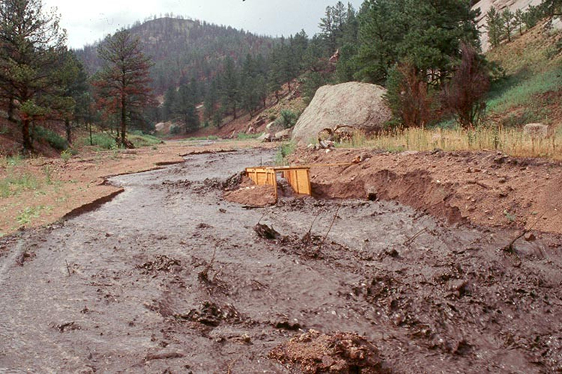
- A consequence of wildfire is the increased probability of flash floods. This flash flood occurred in Spring Creek on July 29, 1997, within the area burned by the Buffalo Creek Fire. The view is upstream and the discharge is about 5.0 cubic meters per second from a maximum 30-minute rainfall intensity of about 19 millimeters per hour. Rainfall-runoff relations suggest a rainfall threshold at about 10 millimeters per hour above which much larger flash floods occur. (Photo Source: John A. Moody, USGS)
Videos
-

- Willamette Valley Flood of 1996: 20 Years Later
-

- Sunrise Rewind: The flood of 1996
-

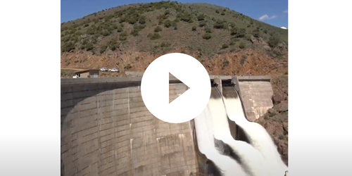
- Storm Series: Utah’s Flooding Nightmare. The 2005 St. George Flood
-
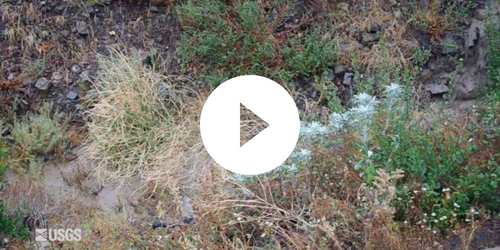
- Post-Fire Flooding and Debris Flow
-
- How Wildfires Impact Denver Water
Case Studies
Canyon Lake Dam (South Dakota, 1972)
The Friday afternoon of June 9, 1972 was the beginning of a tragedy for Rapid City, South Dakota along the eastern slopes of the Black Hills mountain range. Scattered showers from the previous days had left the ground saturated while a low-level air mass...
Castlewood Canyon Dam (Colorado, 1933)
Castlewood Canyon Dam was constructed in 1890 across Cherry Creek, 40 miles southeast of Denver, Colorado. The masonry and rock-fill structure, built from local materials, was around 600 feet long with a height of 70 feet measured...
Columbia River Levees at Vanport (Oregon, 1948)
On May 30, 1948, rising floodwaters of the Columbia River breached a railroad fill acting as a levee and flooded the city of Vanport, Oregon. At the time, Vanport was Oregon’s second largest city and World War II’s largest federal housing project.
Front Range Flood (Colorado, 2013)
The September 2013 rainfall that occurred on the Front Range of Colorado was the result of an unusual, late season storm event where warm moisture and upslope winds allowed this regional storm to dump up to 17 inches of rain over a seven day period.
Hawkins Dam (Washington, 2014)
Hawkins Dam impounded the most downstream reservoir in the Wenner Lakes chain of manmade lakes located 6 miles Southeast of Twisp WA in Okanogan County. Hawkins Dam Impounded Wenner Lake No. 1. Hawkins Dam is a 35-foot high earthfill dam with a crest length of 350 feet and impounds a 4-acre reservoir with a volume of 22 acre-feet...
Hebgen Dam (Montana, 1959)
Just before midnight on August 17th 1959 in southwest Montana, in the vicinity of Yellowstone National Park, a Mw 7.3 earthquake caused an estimated 36 to 43 million cubic yard rockslide to rapidly cross the Madison River and continue up the opposite canyon...
Lake Delhi Dam (Iowa, 2010)
Lake Delhi Dam was originally constructed by the Interstate Power Company between 1922 and 1929 for hydroelectric power generation. The dam is located in Iowa approximately 1.4 miles south of Delhi on the Maquoketa River and impounds the nine-mile-long Lake Delhi. Reaching a maximum height...
Oroville Dam (California, 2017)
With a height of 770 feet, Oroville Dam is the tallest dam in the United States. Completed in 1968 and located north of Sacramento in the foothills of the Sierra Nevada mountains, this large earthfill embankment dam is owned by the California Department of Water Resources (DWR) and is one of the key features...
Palagnedra Dam (Switzerland, 1978)
Palagnedra Dam was constructed between 1950 and 1952 on the Melezza River located in the country of Switzerland. Palagnedra Dam is a 72-meter tall, 120-meter long, concrete gravity arch dam, primarily constructed for hydropower.
Spencer Dam (Nebraska, 2019)
Spencer Dam was a dam constructed for hydropower in 1927 on the Niobrara River in northern Nebraska. The dam consisted of a 3,200-foot-long embankment section and a 500-foot-long powerhouse/spillway section. The dam’s maximum height was 26 feet.
Additional Case Studies (Not Yet Developed)
- Willamette Valley Flood (Oregon, 1996)
Best Practices
Emergency Action Planning for State Regulated High-Hazard Potential Dams: Findings, Recommendations, and Strategies
Author: Federal Emergency Management Agency
Date Published: 2007

Federal Guidelines for Dam Safety: Emergency Action Planning for Dams
Author: Federal Emergency Management Agency
Date Published: 2013

Federal Guidelines for Inundation Mapping of Flood Risks Associated with Dam Incidents and Failures
Author: Federal Emergency Management Agency
Date Published: 2013

Technical Manual: Overtopping Protection for Dams
Author: Federal Emergency Management Agency
Date Published: 2014

Selecting and Accommodating Inflow Design Floods for Dams
Author: Federal Emergency Management Agency
Date Published: 2013
Summary of Existing Guidelines for Hydrologic Safety of Dams
Author: Federal Emergency Management Agency
Date Published: 2012
Other Resources
Hydrologic and Erosion Responses of Burned Watersheds
Author: United States Geological Survey
USGS Webpage